Very warm, humid conditions stay as thunderstorms exit
Mother Nature over-delivered on rainfall in portions of Minnesota and western Wisconsin overnight. Widely scattered thunderstorms blossomed into a rather large cluster of showers and thunderstorms.
This enhanced infrared satellite image depicts the colder cloud tops of storms (blue/green) at 5:30 a.m.

The screen capture of the Duluth National Weather Service radar at 6:35 a.m. showed the thunderstorms tracking through the Arrowhead region and northern Wisconsin.

Showers and thunderstorms are expected to slowly shift east through Wisconsin this morning.
Create a More Connected Minnesota
MPR News is your trusted resource for the news you need. With your support, MPR News brings accessible, courageous journalism and authentic conversation to everyone - free of paywalls and barriers. Your gift makes a difference.
The storm total precipitation estimated from the Twin Cities National Weather Service radar identified where the heaviest precipitation occurred last night. This screen capture image is from 6:35 a.m. Note the rain had not yet reached Rochester.
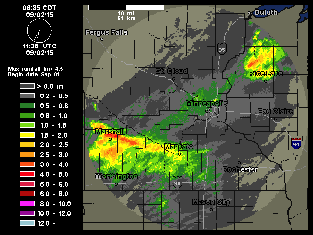
The rain gauge at Mankato, Minn., collected 1.39 inches. Marshall, Minn., tallied more than 1 inch. In the Twin Cities metro area, Crystal Airport recorded 0.49 inch of rain.
As skies clear, we will be draped in sunshine and sultry air. Where the clouds linger, temperatures will be held down a tad. And the cooler waters of Lake Superior will hold the temperatures in the 70s along the shoreline.

The mercury has a good shot of topping out around 90 along the border of the Dakotas and Minnesota.

Dew points that reached into the lower 70s in southern Minnesota on Tuesday are expected to hoover around 70 this afternoon. Dew points in the 50s in northern Minnesota Tuesday afternoon should climb into the 60s as we move through the afternoon.
The warm and humid air mass is expected to hang around through the weekend, an extension of summer leading up to Labor Day. Here are your projected high temperatures for Saturday.
