Spongy again today, another sunny weekend
The sky is crying
Look at the tears roll down the streets -- Elmore James
Elmore James nailed it. One look outside today and we know what it must be like to live in a sponge. Our slow moving soggy low pressure system spins itself out today across the Upper Midwest.
[image]
Create a More Connected Minnesota
MPR News is your trusted resource for the news you need. With your support, MPR News brings accessible, courageous journalism and authentic conversation to everyone - free of paywalls and barriers. Your gift makes a difference.
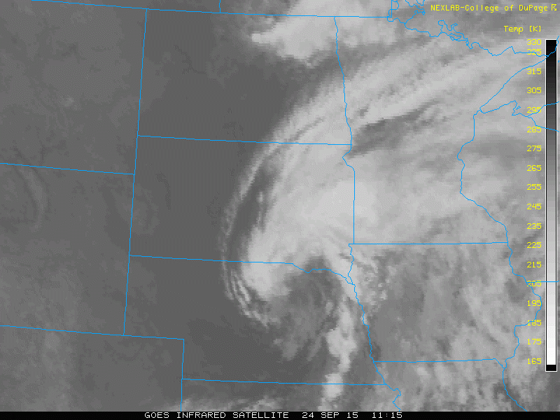
You can clearly see the stalled center of circulation spinning southwest of Sioux Falls, S.D., on the National Oceanic and Atmospheric Administration's GOES 2 km resolution infrared satellite loop.
cyclolysis Any weakening of cyclonic circulation in the atmosphere; the opposite of cyclogenesis. -- Glossary of the American Meteorological Society
That's what happens when low pressure systems get cut off from the main jet stream. Our slow moving low fills in and fades away gradually over the next 24 hours across Minnesota. Behind it, southerly winds deliver another unseasonably mild air mass for late September. Another northbound warm front in late September.
Some of the heavier rainfall totals have come in from Pine County through the North Shore and northwest Wisconsin.
Proctor [St. Louis Co, MN] TRAINED SPOTTER reports HEAVY RAIN of 1.52 INCH at 23 Sep, 10:58 PM CDT --
5 NW TWO Harbors [Lake Co, MN] TRAINED SPOTTER reports HEAVY RAIN of 2.05 INCH at 23 Sep, 8:30 PM CDT -- STORM TOTAL PRECIPITATION. SINCE 143 PM AN ADDITIONAL 0.89 INCHES OF RAIN FELL.
2 SW Hinckley [Pine Co, MN] TRAINED SPOTTER reports HEAVY RAIN of 2.30 INCH at 23 Sep, 9:52 PM CDT --
3 SE Hermantown [St. Louis Co, MN] NWS EMPLOYEE reports HEAVY RAIN of 1.76 INCH at 23 Sep, 5:51 PM CDT -- STORM TOTAL RAINFALL. RECEIVED AN ADDITIONAL 0.12 INCHES OF RAIN SINCE 127 PM.
4 E Cornucopia [Bayfield Co, WI] TRAINED SPOTTER reports HEAVY RAIN of 3.25 INCH at 23 Sep, 6:00 PM CDT --
8 ENE Boulder Lake [St. Louis Co, MN] TRAINED SPOTTER reports HEAVY RAIN of 2.73 INCH at 5:22 AM CDT -- STILL RAINING.
[image]
Forecast: Brighter weekend ahead
I don't know who we paid off to get all awesome weekend this September, but I'm okay with that. We do it again this weekend. Bright sunshine and temperatures 10 to 15 degrees warmer than average? Somebody pinch me.

Longer range outlook: Mild overall with a chance of frost?
The weather crystal ball gets a little murkier as we gaze into October. Signs of a cooler air mass nudge south by the middle of next week. Overall the pattern still seems to favor warmer than average conditions into the first week or so of October. NOAA's Climate Prediction Center bathes the entire lower 48 states in red.

I'm still keeping an eye out for possible frost late next week up north, and possibly closer to the metro by the end of the first week of October.
Stay tuned.