Sunny Friday, typical mixed June weekend
There are the days we are reminded as meteorologists how far forecast models have evolved, and how far they still have to go.
Southern Minnesota dodged the proverbial weather bullet as our latest rain system vastly unperformed model expectations. Flash flood watches were dropped early.
A good soaking rain? Yes. Multi-inch flash flooding torrents? Not so much.
We enjoy a return to sunshine Friday across Minnesota as high pressure brings drier skies. The weekend looks like June so far, a mix of some sunshine and scattered showers.
Create a More Connected Minnesota
MPR News is your trusted resource for the news you need. With your support, MPR News brings accessible, courageous journalism and authentic conversation to everyone - free of paywalls and barriers. Your gift makes a difference.

Parade of lows
We expect this in June in Minnesota. As the jet stream struggles to lift north into the favored summertime position in Canada, the atmospheric river of air high overhead drags another soggy low pressure system over Minnesota every two to three days.

We dry out for about 48 hours, before the next chance of showers nudges in Saturday night into Sunday. Squeeze those baseball games and bike rides in Friday and early Saturday if you can.

Drought done
The good news about our spring in Minnesota? Most locations have picked up 7 inches-plus rainfall totals since April 1. That pretty much wiped out drought across the state.

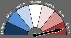
El Niño in full bloom
The National Oceanic and Atmospheric Administration's latest monthly El Niño southern oscillation update confirms what we've been watching for weeks. El Niño is in full bloom and is expected to peak with a very strong event this fall into winter.
Here's more detail from NOAA's latest ENSO Diagnostics Discussion.
ENSO Alert System Status: El Niño Advisory
Synopsis: There is a greater than 90% chance that El Niño will continue through Northern Hemisphere fall 2015, and around an 85% chance it will last through the 2015-16 winter.
Nearly all models predict El Niño to continue throughout 2015, with many predicting SST anomalies to increase into the late fall 2015 (Fig. 6). For the fall and early winter, the consensus of forecasters slightly favors a strong event (3-month values of the Niño-3.4 index +1.5°C or greater), relative to a weaker event.
However, this prediction may vary in the months ahead as strength forecasts are the most challenging aspect of ENSO prediction. A moderate, weak, or even no El Niño remains possible, though at increasingly lesser odds. There is a greater than 90% chance that El Niño will continue through Northern Hemisphere fall 2015, and around an 85% chance it will last through the 2015- 16 winter (click CPC/IRI consensus forecast for the chance of each outcome for each 3-month period).
Across the contiguous United States, temperature and precipitation impacts associated with El Niño are expected to remain minimal during the Northern Hemisphere summer and increase into the late fall and winter (the 3-month seasonal outlook will be updated on Thursday June 18th).
El Niño will likely be a contributor to a below normal Atlantic hurricane season, and above-normal hurricane seasons in both the central and eastern Pacific hurricane basins.
