Warmest day of 2014 so far Sunday, wet Monday, milder again late next week?

It's baby steps into spring this year in Minnesota.
This weekend may restore your faith that the season formerly known as spring will actually arrive this year.
I know many of us are fragile after the coldest Minnesota winter in 35 years, but I keep trying to remind people that March is usually more winter than spring in Minnesota. Maybe we got spoiled by the tropical March of 2012, then crushed by one of the coldest springs last year.
It may not be all unicorns and rainbows on the weather maps the next two weeks, but I continue to see a steady trend (with a speed bump or two) towards a milder pattern in the next 2 weeks.
Create a More Connected Minnesota
MPR News is your trusted resource for the news you need. With your support, MPR News brings accessible, courageous journalism and authentic conversation to everyone - free of paywalls and barriers. Your gift makes a difference.
Temps in the 40s and 50s this weekend with 60s in southern Minnesota?
That's progress.
[image]
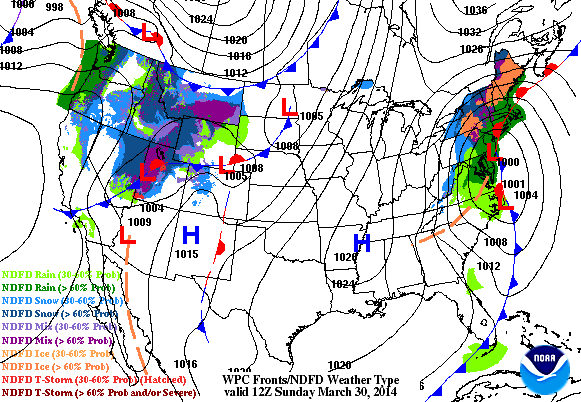
Springy weekend
You may see some unusual sights around Minnesota this weekend. Long lost neighbors coming out of hibernation. Kids wheeling bikes and Big Wheels on your local street. A line up at the corner Dairy Queen Sunday afternoon?
Warmer (southerly) breezes begin to blow Saturday, and by Sunday the warmest air mass of the year blows into Minnesota.
The National Oceanic and Atmospheric Administration's Global Forecast System model has been the most conservative with the weekend warm up. Here's the close in breakdown for the weekend forecast.

The European Centre for Medium-Range Weather Forecasts continues to pump out temps pushing 60 degrees in the metro Sunday.
My read? Upper 50s look very likely, and I can't rule out a shot at 60 in the metro by 3 p.m. to 5 p.m. Sunday afternoon. The best chance of a bank thermometer flashing 60 Sunday occurs in the southwest metro communities like Excelsior, Chanhassen, Chaska and Victoria.

NOAA's digital output is not shy about pumping 60s into southern Minnesota Sunday, with 70 nipping at our southern border and temps near 80 degrees in Nebraska and Kansas. Yes, it's spring to the southwest, and it's edging closer to Minnesota.

Sure is nice to see yellow and red on the weather maps again!

Rain to snow chance returns Monday
For once, the timing is perfect, a nice weekend with rain and potential snow holding off until Monday.
The latest read on Monday's incoming weather system is for a more westerly track. That would favor another system similar to what we saw Thursday staring as rain in the metro that could ends as wet snow Monday night.
Again, there is the potential for some heavier snowfall totals favoring areas north and west of the Twin Cities.
Here's the latest read from the Duluth National Weather Service.
The latest European model and GFS runs suggest mostly rain for the metro Monday, with a potential change to snow Monday night.
The best indicator of the rain snow line in colder weather systems is usually the 850 millibar 0 degree (32 degree Fahrenheit) isotherm which rides about 5,000 feet above ground level. The GFS keeps the "850-zero" line well north of the metro all day Monday.

If that verifies, expect mostly rain with temps in the 40s in the metro Monday, with possible changeover to wet snow as the system departs Monday night.

Again, the European model is the more westerly, and warmer solution Monday suggesting another day of temps in the 50s until the low swings by with cooler weather, and a change to snow.

North central and northeast Minnesota may again see some heavy snowfall totals Monday and Monday night.
Stay tuned.
Cooler next week then milder again next weekend?
Next week's forecast looks cooler, but many details remain uncertain. It does not look as cold as it did a few days ago.
The European model suggests a chance of rain/snow Wednesday and/or Thursday. The GFS trends are steering that system to the south and sparing Minnesota another big dose of potentially wintry precip. We'll let them duke it out in the next few days so stay tuned on that one.
Both of the main medium-range forecast models suggest a welcome milder southerly flow returns by next weekend.

April showers may ride in by next Sunday if this pans out. Two milder spring weekends in a row?
Priceless.

Twins Tracker: opening day forecast
At around 3 p.m. on Monday April 7, 40,000 Minnesotans will make the pilgrimage to Target Field to welcome a new Twins baseball season. It may as well be a group hug for spring.
https://twitter.com/Twins/status/449652145759858688/
The longer range forecasts have been all over the place the past few days. I've literally seen model output cranking out everything from a chilly drizzle and 39 degrees, to sunshine and 71.
This will probably change (again), but the latest round of GFS long range guidance suggests a potential passing low with a shower chance and temps in the 50s a week from Monday.
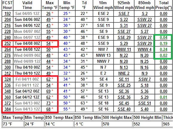
Note the hint at 60s and even 70s in the uber long range forecast.
I don't put much faith into GFS "Dreamcast" data two weeks out. But if it verifies, true spring may be closer than we think!