Weekend dustings, February Thaw next week, snow by Saturday?
Coming up for air
Welcome to the weekend.
Weekends after member drives at MPR are always extra special. MPR staff puts in extra long days on these weeks. When your membership drive manager arrives at 5 a.m. and stays until 10p.m. on the last day of the drive you know it's a big week. (Thanks Jacquie!)
The biggest hero of member drives? You!
Create a More Connected Minnesota
MPR News is your trusted resource for the news you need. With your support, MPR News brings accessible, courageous journalism and authentic conversation to everyone - free of paywalls and barriers. Your gift makes a difference.
Thanks to all who support MPR News, weather, Updraft and all we do. You're amazing, and you're why we keep going everyday to feed the news beast in new and innovative ways. Thank you!

The weekend brings a break, and two more snow chances. Saturday's clipper brings a shot at 1 to 2 inches for central and southern Minnesota. The next wave arrives Sunday night and into Monday morning's rush hour.
Naturally.
Here's a look at Saturday's clipper as it slides through southwest Minnesota on the weekend. Click the map to animate.

The best chance for 1 to 3 inches Saturday brackets the Minnesota River Valley and southwest Minnesota eastward to Rochester, Minn., and La Crosse, Wis.
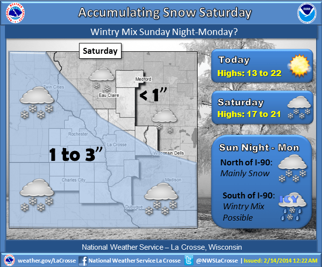
In the metro snowfall favors Saturday afternoon. An inch or so looks likely, with the best chance for some 2 inch totals southwest and south of the metro.
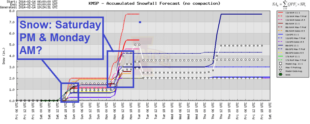
Monday AM rush: Another 'perfectly' timed snowfall?
How do you know when it's rush hour in the metro? If it's snowing, it's rush hour.
At least that's the way it seems this winter. Monday morning may feature another "well timed" shot of snow. A low pressure wave slides through, and snow should break out late Sunday night and continue into Monday AM rush.
It may not be a major winter storm, but 1 to 3 inches can really gum up a Monday morning commute.

Overall we pick up another 1 to 3 inches-plus by noon Monday between the two systems.
Well earned February thaw next week!
We earn our springs and summers in Minnesota. We've definitely earned a February thaw. Temps trend upward next week, and a string of 30s -- and even a shot at 40 is in the weather cards.
Four days above the thawing point this winter? Priceless. Hope you stocked up on "blue juice" for the car windshield.

Signs of snow lurking next Friday night and Saturday?
Even with the warm up next week, you knew winter isn't over yet.
The National Oceanic and Atmospheric Administration's Global Forecast System is spinning up a potent surface low by next Friday, suggesting the potential for significant to potentially heavy snow by Friday night and Saturday.
I know. The Birkie would prefer a nice cold dry day to ski the race. But the chance for snow now looms.

This forecast could change, of course. But for now we need to keep an eye on what looks like a realistic chance for a moderate to potentially heavy snow event by next weekend.
After that temps look to return to more winter like values, but probably not the sustained sub-zero cold we've endured so far this winter.
Finally, here's a great shot of the amazing Lake Superior ice caves from MPR's Julia Schrenkler.
Have a great weekend!