Saturday Clipper trends south, milder days next 2 weeks?
Fun with negative numbers
Yes my mail and person-on-the-street research is overwhelmingly skewed with those who are done with the cold.
This weekend offers some moderation, but the cold is not quite done with us just yet. If you're under 32 or moved to Minnesota in the past three decades, you've never endured a winter quite like this.
It's an old school Minnesota winter.
Create a More Connected Minnesota
MPR News is your trusted resource for the news you need. With your support, MPR News brings accessible, courageous journalism and authentic conversation to everyone - free of paywalls and barriers. Your gift makes a difference.
Here's the sub-zero tracker from the Twin Cities office of the National Weather Service:

Winter weekend
Welcome to yet another classic winter weekend in Minnesota. There's plenty of snow to play in, and ice to fish on. Moderating temps mean it's actually mild enough for most outdoor activities to approach the comfortable range, especially Saturday afternoon. Another shot of cold air oozes south, again, Sunday into early next week.
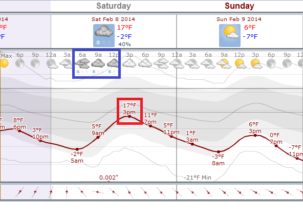
Here's a quick glance at the weekend numbers.
Clipper trends south
The latest trends on Saturday's clipper show a more southerly track. That means a lighter snow potential for the metro; the latest trends suggest a snowy dusting to around an inch on the high end. The best chance for an inch or two should be along the Interstate 90 corridor.
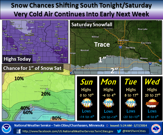
Here's the snowfall output from the National Oceanic and Atmospheric Administration's North American Mesoscale Forecast System.

Here's more on the snowfall story from the La Crosse, Wis., NWS.

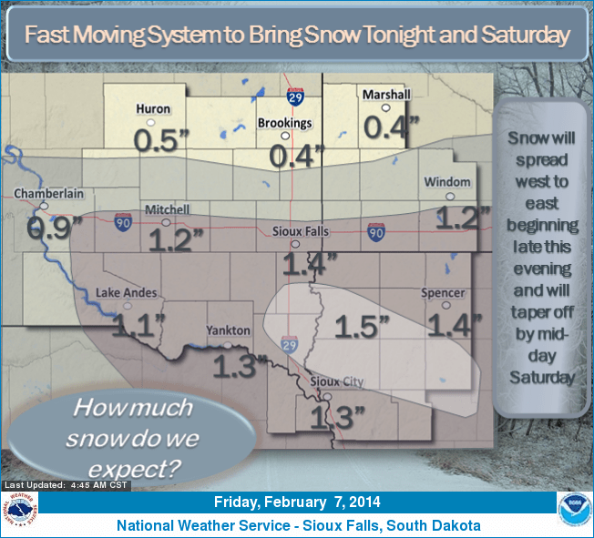
And from our friends in the Sioux Falls, S.D., NWS.
Warming trend next week
All signs still pint to milder temps after a chilly start to next week. The European Centre for Medium-Range Weather Forecasts is probably too cold on Monday morning, but that's when we hit bottom on the next arctic slop-over.
By Wednesday you'll really feel the milder air. A string of days in the 20s and temps mostly above zero is a good start.

NOAA's Global Forecast System is even more optimistic and cranks out a high well into the 30s Wednesday. I may have to declare a Blue Juice Alert Wednesday.

The longer range GFS still shows a trend toward more mild air the week of Feb. 17. The trends still support upper 30s and even a run at 40 degrees around Feb. 18.

Stay tuned!