Temp roller coaster ahead, return of the Polar Vortex?
Digging Out
A wide swath of Minnesota and Wisconsin is digging out from the first significant snowfall in 3 weeks. The system dumped wide ranging snow totals across the metro. A forecast of 1 to 6 inches for the Twin Cities metro area? That was the right one, with about 1 inch at many locations in the west metro, and a hefty 6 inches in Hudson, Wis.
Reading this from Chaska in the southwest metro? What's the big deal? A wispy inch on my driveway. Heading home to Hudson? Where the heck did this 6 inches come from??
Here's the snowfall map from the Twin Cities office of the National Weather Service highlighting the big metro snowfall gradient.
Create a More Connected Minnesota
MPR News is your trusted resource for the news you need. With your support, MPR News brings accessible, courageous journalism and authentic conversation to everyone - free of paywalls and barriers. Your gift makes a difference.

Rapidly evolving system
Tuesday morning's Clipper was a classic example of a weather system developing, and deepening right overhead. That's why the models had a tougher time getting a hold of this system, and why our forecast confidence was lower than usual.

People sometimes tend to think weather systems are "static" and assume what happened 200 miles "upstream" is what we'll get. Tuesday's snow event is proof that nothing could be further from the truth.
It's awesome how well educated most Minnesotans are about weather. We live in a state full of armchair meteorologists. But as they say, a little (weather) knowledge can be a dangerous thing sometimes. I smile thinking I have literally heard discussions like these a thousand times.
"The storm dropped x inches in Winnipeg so that's what we'll get right?" " My cell phone radar app is snow free snow in city X, so it's going to miss us." "Hey, I can read the models as good as those weather guys and gals."
Just enough information to be dangerous.
Be careful out there making assumptions about what you see on your favorite smart phone app or armchair model run. Sometimes they are only as good as the one model they are tied to, or the skill of the programs they run on.
I-94 system
Her's the bigger picture on snowfall totals statewide showing how the latest Clipper made a beeline down Interstate 94. The Golden Snow Shovel? Eau Claire picking up a whopping 8 inches-plus!
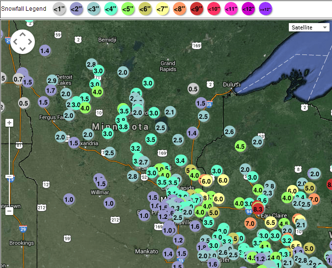
Here's a closer look at snowfall totals for the Red River Valley and southeast Minnesota and Wisconsin.
'White Gold' or snowy commuting nightmare? Winter weather is all about perspective
"There really is no bad weather, just different kinds of good weather." -Anonymous
As a weather practitioner we hear it all. It's amazing how there are as many differing opinions on what is "good" or "bad" weather.
Ski area? Love the fresh powder! It's quite literally White Gold at the cash registers. Snow lovers rejoice!
Daily freeway commuter? Not so much. Time delays, fender benders.
Extreme cold from Polar Vortex delivers -20 to -40 degrees? Great for killing invasive pests! Not so much when it closes your ski area's revenue down for 2 days.
Soaking rain? Farmers take to to the bank. Car wash concession revenue plummets. Little League games get rained out.
You get the picture. How you feel about certain kinds of weather depends on your perspective. We are a nation full of weather 'special interests.' I for one am grateful we can't control the weather. We can barely pass a budget in Congress. How in the world would we agree on what this week's weather will be?
What's your perspective on "good" weather?
Roller Coaster temps ahead
Get ready for some major ups and downs on your thermometer in the next week. Sub-zero temps greet many Minnesotans Wednesday morning. Then a mini warm front arrives with temps actually rising to near 30 degrees Wednesday night, before the next arctic sideswipe Thursday and Friday. January Thaw part two kicks in by Sunday. Here's a look at the wild temp ride in the next week. This may make the stock market look tame.

Return of the Polar Vortex?
It's early and I wouldn't bet the farm on this just yet.
But there are indications that after our balmy thaw early next week, another bitterly cold Polar Vortex may take a swipe at the Upper Midwest. The Global Forecast System has been consistent for a few runs now that much colder air may invade by the weekend of Jan. 25-26. Here's the upper air map from NOAA's GFS model, showing an arm of the Polar Vortex stabbing south at Minnesota in about 11 days.

The accompanying temperature projections are attention getting. Another shot of 20-below for the metro?

Again it's still early, and the GFS has a way of backing off on longer range cold snaps.
Still as we say in the weather biz, stay tuned.