Moderation to mild; ice quakes and Northern Lights

Temperatures bottomed out last evening and in the early morning hours in Minnesota while cold air pooled over central Wisconsin last night. By daybreak the thermometer had gone from a low of -15 at Brainerd to 10 above zero -- all without the benefit of sunshine.

Low temperatures reported to the National Weather Service at Duluth included: -33 at Silver Bay, -31 at Ely and Two Harbors, and -29 at Brainerd. Rice Lake, Wis. checked in with a bone-chilling -31 below this morning.
There was a nice steady rise in the temperature today at the St. Paul Campus of the University of Minnesota.

We'll enjoy another couple of days of above normal temperatures after a very chilly start to 2014. Perhaps we can stay out of the wind chill advisory and warning category for a spell?
Create a More Connected Minnesota
MPR News is your trusted resource for the news you need. With your support, MPR News brings accessible, courageous journalism and authentic conversation to everyone - free of paywalls and barriers. Your gift makes a difference.

For the first eight days of January, International Falls has had an average low temperature of -28.8 degrees. Very deserving of the title "Ice Box of the Nation!"
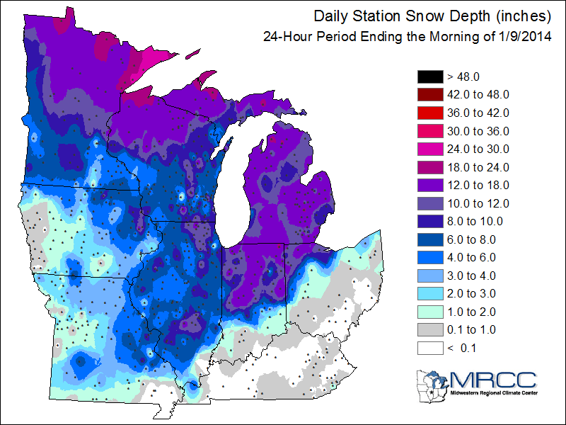
Snow depth will not likely be affected much by the milder temperatures the next couple of days. So if you are looking to take part in outdoor recreation the weekend temperatures may be to your liking. There will be some wind that you may have to contend with.

A closer look at the rather generous snow cover in our neck of the woods.
The frigid air mass that blanketed much of the eastern USA the past few days may have induced a rare occurrence of ice quakes in Wisconsin. Residents reported sounds that could not be attributed to normal residential activities.
Perhaps the unknown source for creaks and groans was caused by the expansion of ice in the geological profile resulting in rapid shifting of the soil.
From a story posted by the FOX11 TV station in Fond du lac, Wisconsin....
University of Wisconsin-Milwaukee seismologist Brett Ketter tells Action Reporter Media he experienced an ice quake this week and initially thought the pipes had burst in his house. Ketter says he ran outside in his slippers to see if something had hit his house.
Geologists say the booms were likely a phenomenon commonly known as an ice quake. It's caused by water that sinks into the soil and bedrock where it freezes and expands, causing an explosive popping sound that feels like a mild earthquake.
If we understand the processes that initiate sink holes in the southern states, we can probably hypothesize that ice quakes, in extremely cold conditions, can be indeed micro in nature.
Get the family together this evening for what might turn out to be an opportunity to view the northern lights. NOAA's Space Weather Center reported a strong solar flare released in the past 36 hours that could allow for a presentation of the aurora borealis tonight.
From the Space Weather Center:
SWPC Forecasters are anticipating G3 (Strong) Geomagnetic Storm conditions to occur on January 9 and 10. The source of this disturbance is a fairly fast Earth-directed coronal mass ejection (CME) launched from centrally-located Region 1944 at 1832 UTC (1:32 p.m. EST) on January 7.

The temperatures may climb above the thawing mark in locations of southern Minnesota on Friday with a small dip in temperatures on Saturday.

It will be nice to have the mercury stay above zero overnight.
Some snow is expected to track through southeast Minnesota and into Wisconsin on Friday night. Currently it looks like the Twin Cities and Duluth will get swiped with up to about an inch of new snow.

Looking out into the middle part of January, climatologically the coldest time of winter, we see Minnesota straddling the divide of above and below normal temperatures. For some of us, it is better than finding ourselves entrenched in the core of below normal temperatures.
