Oct-ember forecast? Weather maps hint at frost and possible snow
Halloween is about two weeks away, and the weather maps are looking a little scary these days.
We expect the late October chill. We expect the old fashioned fall rain storms. What we may not expect in late October is early snowfall. It doesn't happen every year.
Looking at the weather maps lately, early snow is looking more likely this October.
A late frost and an early snowfall in the same year? Only in Minnesota.
Create a More Connected Minnesota
MPR News is your trusted resource for the news you need. With your support, MPR News brings accessible, courageous journalism and authentic conversation to everyone - free of paywalls and barriers. Your gift makes a difference.

October soaker
Call it another 'million dollar rain' in Minnesota. Our latest rain storm brought widespread soaking rains to the Upper Midwest. Here's the updated 24 hour rainfall totals which show widespread 1 inch totals with some 2 inch and 3 inch totals in western Minnesota and eastern South Dakota.
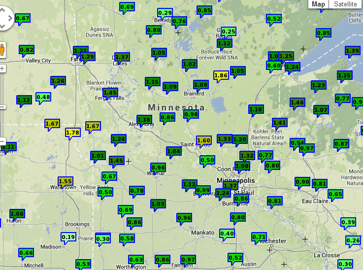
These October stratiform rains are important because they fall over large areas and fall at a rate that is ideal for soaking into parched soils with minimal runoff. These valuable rains recharge soils before the winter freeze-up. With minimal evaporation between now and winter, much of the rain that fell this week will still be available in spring to jump start the 2014 growing season.
Bank.
Frosty weekend?
Our storm pulls out and pulls in colder Canadian air as we move through this week. By this weekend, the right combination of cold air, clear skies and light winds around sunrise could produce the season's first frost in the inner metro core. We'll flirt with a string of upper 30s later this week.
Here's the Euro model Twin Cities output.

The best chance of a 32 degree temp at Minneapolis-St. Paul International Airport appears to be Sunday morning.

Snowy rumors?
The weather maps are looking just cold enough and just wet enough to mention the possibility of a few weekend flurries -- and even a chance for some light snow with a descending 'Clipper' next Tuesday. Here's the early GFS take on snow chances next Tuesday.

I wouldn't get out the shovel just yet, but the maps are looking increasingly wintery in late October.
Stay tuned.