AM slush potential trends to rain, lessons from Sandy 1 year later?
It's that time of the year when meteorologists in Minnesota can't assume anything.
Late October usually brings rain. But cool temperatures just a few critical degrees, and twitter bombs may fly from irate listeners over that slushy two inches of 'cold rain' decorating their lawn. That's why we cast wary eyes at incoming weather systems as Halloween approaches. We've seen some scary things on the weather maps this time of year.

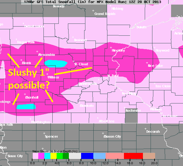
Tuesday mornings slush potential doesn't look too scary for Minnesota. Moisture from our next weather system is streaming north, just as sub-freezing air aloft is ready slide away to the north. The result could be a few minutes to hours of slushy snow flakes. With temps hovering around the freezing mark, there may be enough to coat a few lawns and fields early Tuesday morning before precipitation changes to a harmless rain.
Here's what the Global Forecast System run thinks about the chances for a (brief) slushy coating on grassy areas early Tuesday morning for parts of central and southern Minnesota.
Create a More Connected Minnesota
MPR News is your trusted resource for the news you need. With your support, MPR News brings accessible, courageous journalism and authentic conversation to everyone - free of paywalls and barriers. Your gift makes a difference.
Temperature Critical
As we slide slowly toward winter in Minnesota, precipitation type is all about the temperature profile in the lowest mile or so above the ground. Temps hover near freezing early Tuesday, then gradually warm to near 40 by lunchtime. That should be enough to change any renegade snow showers to rain as the day wears on.
Here's the 3-hour interval breakdown for Tuesday from Weatherspark.

Main low arrives Wednesday night
The center of the developing low pressure storm will ride north Wednesday toward Minnesota. The best lift and moisture arrives late Wednesday and Wednesday night. That's when heavier, steadier soaking rains may bring up to 1 inch of much needed moisture.
Here's National Oceanic and Atmospheric Administration's NAM model position on the advancing low and rainfall totals from the College of DuPage.

Close Call: Drying out for trick or treat time?
Our Halloween week weather maker shows signs of pulling out just in time for trick-or-treaters to hit the streets Thursday evening. Will the skies dry in time for ghouls & ghostliness Thursday evening? It's going to be a close call.
One thing look certain. It will be chilly with temps in the 40s at best -- and a cool northwest breeze building in. Here's the Euro model's breakdown of a Wednesday night soaking, with a trend toward lighter showers fading Halloween day.

Sandy 1 year later: What have we learned?
Hurricane Sandy devastated New Jersey and New York coastlines on Oct. 29, 2012.
One year later we've learned a lot about the limits of forecasting hurricanes. We learned (again) that the European model product is better than NOAA's forecast models, and NOAA is playing catch up the ECMWF with vastly superior computing power and model physics.
We learned the hard way about how vulnerable many US coastal cities can be to future hurricanes and storm surges. We've learned our insurance industry and federal flood programs are facing incredible stress from an increase losses from extreme weather. Residents of New York and New Jersey have learned that what we call 'home' can be swept away in hours. Many have still not returned to or rebuilt what was once called home as rebuilding costs and insurance rates skyrocket.
I spoke recently with Andrew Freedman and Bernadette Woods Placky from Climate Central about their coverage of the one-year mark of Hurricane Sandy.
Here are some clips from Climate Central's excellent series of pieces published today.
One Year Later: The Aftermath of Hurricane Sandy
Superstorm Sandy — part hurricane, part fearsome nor’easter — battered the Eastern U.S. in October 2012. The storm brought a record storm surge to New York City and the New Jersey Shore, killing 159 and causing an estimated $65 billion in damage. The megastorm drove home the vulnerability of coastal cities like New York to sea level rise and storm surge. One year later, we look at Sandy's aftermath.

Experts Say Sandy Showed Limits of an Accurate Forecast
Thanks to a vast network of data-gathering instruments on the ground, attached to balloons launched twice daily across the U.S., and orbiting satellites higher in space, along with the sophisticated computer models that run on supercomputers of ever-increasing speed, weather forecasts are more accurate than they have ever been, as was demonstrated with Hurricane Sandy.
A week before the “superstorm” devastated the East Coast, the models available to the National Weather Service showed that Hurricane Sandy was going to do something that no storm had ever done — slam into the New Jersey coastline at a nearly 90-degree angle, going from east to west. That track would bring a massive storm surge into New York City, New Jersey, and Long Island, a nearly perfect storm or worst-case scenario.
Yet Sandy also demonstrated the frustrating limitations of an accurate forecast. Despite the advanced notice and the huge threat it posed everywhere from Massachusetts to Maryland, the storm still killed 159 people, including 44 within New York City alone. Most of the New York victims drowned from coastal flooding.
Even now, nearly a year after Sandy helped reshape the weather enterprise in the U.S., a gap is growing between the capabilities of weather forecasters and the state of risk communications and emergency preparedness in the country.