Best week of fall? Colors now popping up north
Our Minnesota chamber of commerce weather pattern continues this week. Plenty of sun mixed with a few clouds. Temps running +5 to +10 degrees above average. Mild southerly breezes. Dew points in the comfy 40s and 50s?
It doesn't get much better than this for many Minnesotans. After a reluctant spring and slow start to summer our Minnesota psyche needed a second August this year. It's been a September to remember.
The only item on the weather wish list: some more rain to make up a 2 to 4 inch rainfall deficit in much of the state. Preferably at night, not on the weekend. Sure thing.
It's a good thing nobody controls the weather. Can you imagine the debates in the Capitol about when and how much to make it rain? Would a small but vocal percentage of Minnesotans want milder, snow and ice free winters? Would MnDOT lobby for snowless rush hours?
Create a More Connected Minnesota
MPR News is your trusted resource for the news you need. With your support, MPR News brings accessible, courageous journalism and authentic conversation to everyone - free of paywalls and barriers. Your gift makes a difference.
Just sit back and enjoy the fine weather cards dealt to Minnesota this week. And thank your local weather person?
+3.7 degrees - temps vs. average so far in September at Minneapolis-St. Paul International Airport
-1.08 inches - rainfall vs. average at MSP in September (1.21 inches so far)
October 7th - average date of first 32 degree temp at MSP Airport

Week at a glance: Mild and dry
The weather numbers look good this week. Temps should run about 5 to 10 degrees above average. That means 70s most of this week, with a shot at 80 by Thursday or Friday. There's a slight chance of a passing shower Tuesday, but the best chance for a little rain comes Friday. Here's the European Centre for Medium-Range Weather Forecasts model output from Weatherspark.

Bad hair day alert: Winds kicking up today
A tight pressure gradient means gusty south winds today. Winds will gust to 30 mph in most areas by afternoon. Here's the wind map from the National Oceanic and Atmospheric Administration.

Colors beginning to pop up north
Changes in daylight and the cooler nights are beginning to flare some color up north now. Some pockets of 25 to 50 percent are showing up. Here's Sunday's fall color update from the Minnesota Department of Natural Resources.

First frost in sight?
Southerly breezes will keep Minnesota milder than average, and probably keep the metro and southern Minnesota frost free through September.
There are some signs of a much colder shot of air late next week. The GFS was hinting at frost potential by around Oct. 5 in the metro with lows in the low 30s late Sunday. The overnight model runs backed off that notion a bit, but still bring temps in the low 30s by the morning of Oct. 8. Here's the NOAA Global Forecast System 16-day temperature output.
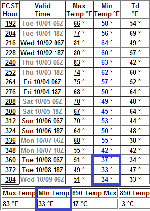
The average date of the first 32 degree temp at MSP is Oct. 7, but note how it varies around the metro.
Enjoy our fine weather this week!