Anatomy of a ‘Biblical’ flood in Boulder
Sometimes it takes days for the magnitude of extreme weather events to become clear.
When Katrina hit, it looked at first like New Orleans had dodged a major bullet. Then the levees gave way. Sandy's devastation last fall only became fully apparent in the days following the disaster. Now, add Boulder to the growing list of "extreme weather" cities.

As final rainfall and flood gauge totals come in, it is now clear that this will be the flood of record for many Colorado communities. Some locations picked up over 21 inches in the unprecedented event. That's literally a year's worth of rain in a couple of days.
Here's a closer look at how the Great Boulder Flood of 2013 happened.
Create a More Connected Minnesota
MPR News is your trusted resource for the news you need. With your support, MPR News brings accessible, courageous journalism and authentic conversation to everyone - free of paywalls and barriers. Your gift makes a difference.
Tropical connection
How does a "Biblical" flood get started? Take a look at this animated water vapor loop form last Thursday. You can see the bright yellow plume of tropical moisture feeding into Colorado from the tropical Pacific.

The nearly stationary upper low over the Rockies continued to feed an incredibly tropical air mass into Colorado for 2-3 days and slam it into the Front Range of the Rockies. That added orographic lift enhanced upward motion, and helped generate record rainfall totals. Weather Underground's Jeff Masters has more on how record precipitable water levels and "upslope" combined to produce the biggest flash flood in Boulder's history.
These sort of upslope rain events are so-named because as the air flows uphill, it expands and cools, forcing the moisture in it to fall as rain. Balloon soundings from Denver last night and this morning recorded the highest levels of September moisture on record for the station. The total precipitable water (PW), which is how much water would fall at the ground if the entire amount of water vapor through the depth of the atmosphere was condensed, was 1.33" at 12Z (8 am EDT) on September 12, and 1.31" at 00Z September 12. The previous September record was 1.23", set on September 10, 1980. Balloon soundings began in 1948.

A year's worth of rain
The final numbers are incredible.
One weather station 3 miles southeast of Boulder recorded 21.13 inches of rainfall with the storms. That's more than the average annual precipitation (rain and snow) for Boulder which is 20.68 inches.
Here's a look at the incredible rainfall totals in and around Boulder from the Denver-Boulder NWS.

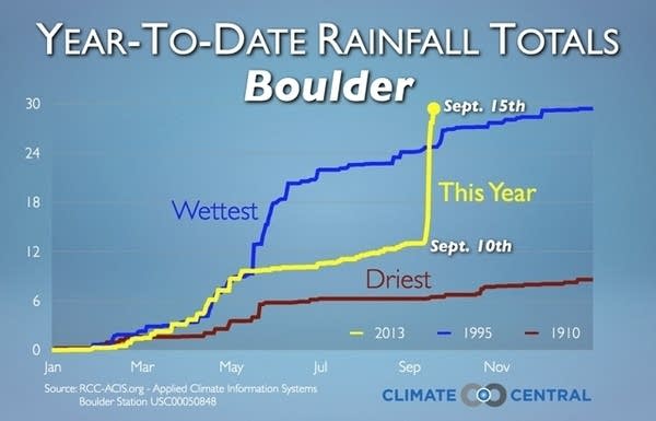
The unprecedented rainfall is literally off the weather charts for Boulder.
The 30.14 inches so far this year already passed Boulder's previous annual precipitation record of 29.93 inches set in 1995 -- with 3 months left to go in 2013.

Climate Central's Andrew Freedman has more illuminating numbers from the flood.
More than 1,000 personnel from the Colorado Air National Guard and other agencies continued to make headway locating and rescuing what are thought to be hundreds to perhaps thousands of people who have been trapped in homes that have been cut off from surrounding towns by washed out roads, bridges, and other infrastructure. The flooding is among the most widespread and extensive that the area has seen in decades or longer, with an estimated 19,000 homes damaged or destroyed, and at least 30 highway bridges taken out by floodwaters.
Along the Big Thompson River, for example, the site of a deadly 1976 flash flood, the river exceeded its 1976 flood height by more than a foot, and remained above the 1976 benchmark for 24 hours, said Robert Henson, a meteorologist at the University Corporation for Atmospheric Research in Boulder.
Some of the rainfall amounts that fell late last week, including the record rainfall in Boulder, qualify this event as having roughly a 0.1 percent chance of occurring in any given year, also referred to as a 1-in-1,000 year event. However, scientists cautioned that such statistical return periods are difficult to calculate given the scarcity of historical records of such massive floods and the shifting nature of probability given population growth, which has put more people and property in harms’ way. They also cited the warming climate, which has increased the risk of extreme precipitation events throughout the U.S.

Did climate change play a role?
While it is still difficult to fingerprint any one extreme weather event to climate change, the overall pattern of the flood fits well with observed changes. A long term drought. A loopy, "stuck" jet stream feeding in record atmospheric moisture due to arctic amplification caused by a warmer arctic? It's a movie we've seen before as recently as last fall with Hurricane with Sandy.
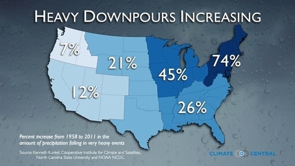
One thing is certain. There is a documented increase in these types of extreme rainfall events in the past few decades in the United States.

Andrew Freedman elaborates on the potential links between Boulder and climate change.
It will take climate scientists many months to complete studies into whether manmade global warming made the Boulder flood more likely to occur, but the amount by which this event has exceeded past events suggests that manmade warming may have played some role by making the event worse than it would have otherwise been.
Extreme rainfall events have become more frequent across the U.S. during the past several decades in part due to manmade global warming. Increasing air and ocean temperatures mean that the air is generally carrying more water vapor than it used to, and this moisture can be tapped by storm systems to yield rain or snow extremes. Trends in extreme precipitation events vary by region, though, and in general the biggest increases have taken place in the Midwest and Northeast. However, most parts of the U.S. have seen an increase in extreme precipitation events, according to the draft National Climate Assessment report that was released this past January. The report goes on to note that in the future, "increases in the frequency and intensity of extreme precipitation events are projected for most U.S. areas.”
It will take more time and plenty of research to tell us why epic floods like Boulder are becoming more common.