Upside down weather pattern: Alaska warmer than Minnesota this summer?
Alaskan Riviera
Minnesota is well known for our chilly climate but we can always count on Alaska being colder in the long run, right?
Not so much in 2013. This morning is a great example.
34 degrees in Longville, Minn., this morning
Create a More Connected Minnesota
MPR News is your trusted resource for the news you need. With your support, MPR News brings accessible, courageous journalism and authentic conversation to everyone - free of paywalls and barriers. Your gift makes a difference.
54 degrees in Fairbanks, Alaska
20 degrees warmer in Fairbanks, Alaska?
It turns out this is not the only time this summer that Fairbanks has been significantly warmer than northern Minnesota. In fact, Fairbanks has set a new record for the most days ever above 80 degrees with 36 days of "summer" heat in the 80s.
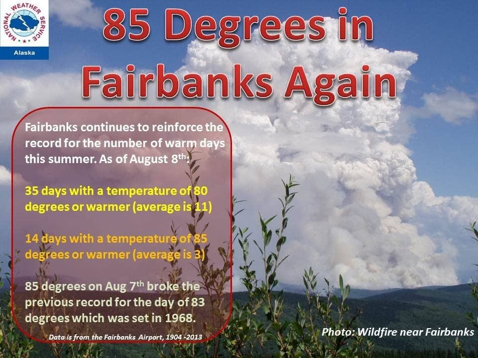
International Falls? Just 20 days above 80 this "summer."
So far in August, Fairbanks (65.9 degrees) is running about 9 degrees warmer than International Falls (57 degrees). That's pretty remarkable stuff.
"Arctic Amplification" to blame?
The "whys" of extreme weather shifts can be tough to pin down. It's sometimes hard to connect the dots on complicated weather patterns.
One emerging theory on why the jet stream is behaving so unusually this year is so called "arctic amplification."

Here's a great explanation on this process from NASA.
As far back as 1896, the Swedish scientist Svante Arrhenius hypothesized that changes in the concentration of carbon dioxide in Earth’s atmosphere could alter surface temperatures. He also suggested that changes would be especially large at high latitudes.
Arrehenius didn’t get every detail right, but his argument has proven to be pretty sound. Since the mid-20th Century, average global temperatures have warmed about 0.6°C (1.1°F), but the warming has not occurred equally everywhere. Temperatures have increased about twice as fast in the Arctic as in the mid-latitudes, a phenomenon known as “Arctic amplification.”
The map above shows global temperature anomalies for 2000 to 2009. It does not depict absolute temperature, but rather how much warmer or colder a region is compared to the norm for that region from 1951 to 1980. Global temperatures from 2000–2009 were on average about 0.6°C higher than they were from 1951–1980. The Arctic, however, was about 2°C warmer.
Why are temperatures warming faster in the Arctic than the rest of the world? The loss of sea ice is one of the most cited reasons. When bright and reflective ice melts, it gives way to a darker ocean; this amplifies the warming trend because the ocean surface absorbs more heat from the Sun than the surface of snow and ice. In more technical terms, losing sea ice reduces Earth’s albedo: the lower the albedo, the more a surface absorbs heat from sunlight rather than reflecting it back to space.
However, other factors contribute as well, explained Anthony Del Genio, a climatologist from NASA’s Goddard Institute for Space Studies. Thunderstorms, for instance, are much more likely to occur in the tropics than the higher latitudes. The storms transport heat from the surface to higher levels of the atmosphere, where global wind patterns sweep it toward higher latitudes. The abundance of thunderstorms creates a near-constant flow of heat away from the tropics, a process that dampens warming near the equator and contributes to Arctic amplification.
The theory is that the recent extreme warming in the Arctic produces less temperature contrast with the mid-latitudes. Since temperature contrast is what drives jet streams, less north/south contrast means a slower, loopier more erratic jet stream. That in turn can mean cooler air diving further south that usual.
It seems counter intuitive, but could a warmer Arctic actually be cooling off places like Minnesota in the short run? That may be what we're seeing this summer.

Food for meteorological thought as we try and explain why our weather patterns seem so odd in 2013.