Million dollar rain this morning? Wetter week ahead; Severe risk Tuesday
Nature's alarm clock: Overnight flashing & splashing
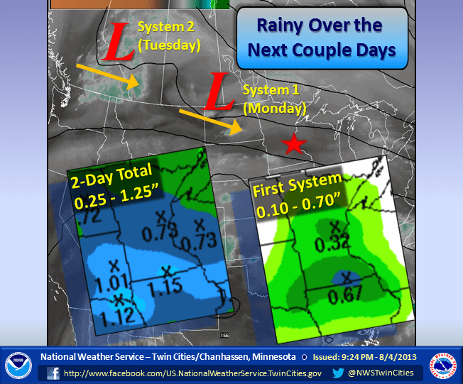
The work week started with two alarms today.
A batch of showers and thunderstorms with some locally heavy downpours rolled through Minnesota into Wisconsin this morning.
Much of southern Minnesota, from the Twin Cities to Redwood Falls, Mankato and Rochester and the Interstate 90 corridor, picked up .50" to 1"+ under the heavier downpours. There were some 2"+ rainfall totals under slower moving storms.
Create a More Connected Minnesota
MPR News is your trusted resource for the news you need. With your support, MPR News brings accessible, courageous journalism and authentic conversation to everyone - free of paywalls and barriers. Your gift makes a difference.
Here are some rainfall total courtesy of Twin Cities National Weather Service this morning:
MAX/MIN TEMPERATURE AND PRECIPITATION TABLE FOR MINNESOTA
NATIONAL WEATHER SERVICE TWIN CITIES/CHANHASSEN MN
736 AM CDT MON AUG 5 2013
VALUES REPRESENT HIGHS YESTERDAY...LOWS OVER THE LAST 12 HOURS AND PRECIPITATION OVER THE LAST 24 HOURS
DLH : DULUTH : 73 / 57 / 0.50
INL : INTERNATIONAL FALLS : 73 / 55 / 0.10
MSP : MINNEAPOLIS MN : 76 / 61 / 0.54
RST : ROCHESTER MN : 73 / 58 / 0.50
STC : ST CLOUD MN : 76 / 58 / 0.31
AXN : ALEXANDRIA MN : 76 / 61 / 0.24
GNA : GRAND MARAIS : 63 / 53 / 0.00
HIB : HIBBING : 74 / 52 / 0.55
RWF : REDWOOD FALLS MN : 78 / 63 / 1.25
EAU : EAU CLAIRE WI : 76 / 55 / 0.10
Doppler storm total rainfall estimates show a good chunk of southern Minnesota picked up .50" to 1" rainfall. The yellow "streaks" are localized corridors where 1.5" to 2" fell.

Thirsty ground eagerly soaked in the rains this morning. While the rain came down heavy at times, no reports of flooding crossed the NWS wires. Here are some of the heavier rainfall totals this morning.
Deephaven in the west metro picked up .95". Blaine 1.35". Hutchinson 1.76". A band of 2" fell from near St. James through Winnebago to Albert Lea.
The upper wave causing the morning rain and thunder moves east this afternoon, and a drier sky may only be able to muster an isolated storm or two.

-Latest Twin Cities radar loop
Severe Risk Tuesday:
Wave #2 moves through Tuesday with another round of scattered rain and T-Storms.
Tomorrow's system could bring some rapidly developing thunderstorms in the afternoon and evening. Combine daytime heating, dew points in the 60s, and a strong cold front approaching and we have the recipe for severe storms. Here's the slight risk area from NOAA's Storm Prediction Center.

Another front will bring rain chances Thursday.

In between, Wednesday looks like the best day of the week right now with plenty of sun and fresh (and less humid) northwest breezes.
Overall, many of us may pick up 1" of needed rainfall this week...with some localized 2"+ totals possible.

Million Dollar Rain?
The overnight soaking is good news for many crops which have gone quite a while without a good drink. Monday's Minnesota crop report will no doubt show a higher percentage of Minnesota's fields a little short on moisture. We may catch up a bit this week. Many farmers will appreciate the rainfall they may get this critical week.