AM rush T-Storms produce 2″+ rainfall, 50+ mph gusts; PM storm chances fade away
Bumpy AM rush hour storms
An early AM line of T-Storms produced wind gusts over 50 mph in the east metro and several 2"+ rainfall reports in under an hour. I recorded a welcome .57" rainfall total at the Weather Lab in the west metro this morning.
Here are some of the storm reports into the Twin Cities NWS this morning.
MPX: Lake Elmo [Washington Co, MN] awos reports TSTM WND GST of M55.00 MPH at 08:45 AM CDT --
Create a More Connected Minnesota
MPR News is your trusted resource for the news you need. With your support, MPR News brings accessible, courageous journalism and authentic conversation to everyone - free of paywalls and barriers. Your gift makes a difference.
MPX: South ST Paul [Dakota Co, MN] awos reports TSTM WND GST of M51.00 MPH at 08:33 AM CDT --
MPX: 1 ENE Redwood Falls [Redwood Co, MN] mesonet reports HEAVY RAIN of M2.12 INCH at 06:27 AM CDT -- one hour.
MPX: 1 NNW Buffalo [Wright Co, MN] mesonet reports HEAVY RAIN of M2.60 INCH at 07:54 AM CDT -- one hour.
MPX: 1 W Shakopee [Scott Co, MN] mesonet reports HEAVY RAIN of M2.16 INCH at 08:04 AM CDT --
MPX: 2 WSW Apple Valley [Dakota Co, MN] mesonet reports HEAVY RAIN of M2.60 INCH at 08:08 AM CDT -- one hour.
Here's the doppler radar shot at 8:40am this morning as storms moved through the east metro moving east at 40 mph.

The morning storms cleared the metro by around 9:30 am. The cold front is lagging...and may trigger another batch of storms this afternoon and evening.

The morning storms "worked over" the atmosphere a bit today...using up some potential energy for PM storms.The severe risk has moved east of the metro.
Here's the latest Twin Cities doppler radar loop
Check possible watches and warning at the Twin Cities NWS
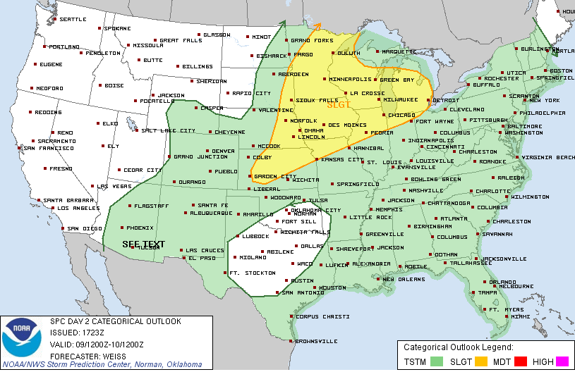
Get the big picture with risk areas at NOAA's Storm Prediction Center
Tuesday Thunder Threat
"Risk" is an interesting word.
We all take risks in life. Some are foolish, and some can pay off. When NOAA's Storm Prediction Center issues a "risk" for severe weather it's usually not good news. The only upside this time may be that after 8 essentially dry days (.03" Sunday) our lawns could actually benefit from decent soaking. We can do without the large hail and potential for wind damage.
Tuesday's storm risk comes courtesy of a cool front that will bring relief from long awaited but still sweaty heat and humidity. A cooler transfusion of clean comfortable Canadian air is just 24-48 hours away.
Speaking of cooler, residents along the North Shore may be wondering if summer will arrive at all this year. While most of Minnesota basked in 80s and low 90s, Grand Marais struggled to reach 54F Sunday. Why is the "summer" of 2013 so reluctant on the North Shore compared to 2012?
And Minnesota's crop report is looking much better after our recent warm dry spell. More in the crop report below. Maybe the Weather Lab will get "root beer float" and "sweet corn" week in yet this summer?
+4.0F Temps vs. average at MSP so far in July
0.03" rainfall total at MSP in past 8 days
5 days of 90+ heat so far this year
31 days of 90+ last year
Tuesday Thunder:
A strong upper level low pressure wave and surface cold front will "phase" over the Upper Midwest Tuesday. That means thunderstorms, and NOAA's SPC has stamped a slight risk for severe weather over Minnesota and the Upper Midwest.
There are signs that the biggest storms may rumble across Iowa into southern Wisconsin and Illinois. Another MCS...or "bow echo" packing damaging winds and hail may race through Des Moines, La Crosse, Madison, Milwaukee and Chicago. SPC paints a higher 30% risk for severe weather to the south.

Metro Split?
I'm still hoping we'll get some garden variety (non-severe) storms in the metro Tuesday.We could use a shot of rain. There are some signs of a potential "split" in storm action Tuesday. The northern stream may produce storms across northern Minnesota, with the more severe MCS racing across Iowa and southern Minnesota. The metro may be in between. It's almost impossible with localized "convective" summertime storms to say for sure exactly where the heaviest storms will set up, but here's the unimpressive metro rainfall outlook from NOAA's Hydrometeorological Prediction Center (HPC).

How do you spell relief? Cold Front
The storm generating cold front will blow through Minnesota by Tuesday night. That means a fresh northwest breeze Wednesday, and a cleaner Canadian air mass. Dew points should plummet into the low to mid 50s by Wednesday night. here's the European model "meteogram" showing rain chances Tuesday and highs near a comfy 80F Wednesday.

Looking Glass: More 90s ahead?
The longer range forecasts call for a fairly delightful run of typical summer weather the next week. Here's the Euro 7-day...which cranks out a string of mostly sunny days with pleasant highs between 26C (79F) and 29C (84F) the next week or so.

The GFS uber long rang product still hints at more sustained heat ahead in about 10 days to 2 weeks.

Bottom line? The next 2 weeks look pretty typical for mid summer in Minnesota.
North Shore: What summer of 2013?
My friends along the North Shore tell me they are still searching for "summer." It's been a cool wet spring and while most of Minnesota has eased nicely into summer weather... persistent fog-chilled breezes off lake Superior have produced many days in the 50s and 60s so far this summer.
Sunday was a great example. Here's a look at high temps Sunday around Minnesota.
Twin Cities 91F
St.Cloud 92F
International Falls 80F
Duluth 69F
Silver Bay 61F
Grand Marais 54F
Why the reluctant spring of 2013? Basically you can blame it on Lake Superior.
Water temps on the big lake are running a good 20F+ cooler than last year at this time when water temps were in the swimmable 70s.

In fact, last year on July 25th the water off Duluth reached a balmy 78.4F...the warmest in a century according to Jay Austin at UMD's Great Lakes Environmental Research Laboratory. Here's what Jay had to say last year.
“It’s pretty safe to say that what we’re seeing here is the warmest that we’ve seen in Lake Superior in a century,” said Jay Austin, a professor at the University of Minnesota at Duluth, who has researched the lake’s water temperatures back to the beginning of the 20th century.
This year? Not so much. Here's a look at current lake temps on Superior...which are running in the 50s along shore...and in the frigid 30s farther out.

Wind currents have been favorable for enhanced "lake effect" this summer. Here's a cool animated visual of currents on the big lake from Great Lakes Environmental Research Laboratory .

The big lake will warm up more in late July....but it looks like nowhere near the toasty levels of 2012. There will be some beautiful days along the Shore this summer...but cool water temps mean the "June Gloom" of Lake Superior may linger this summer at times.
Crop Report: Thigh high by the 8th of July? "You can hear the corn grow"
One of the most interesting weeks of my youth was spent at a corn farm hear Hutchinson west of the Twin Cities. (Cue the jokes...I know.) They say you can literally "hear the corn grow" in mid-summer.
Our recent warm spell has been a boost to Minnesota's corn crop after our soggy spring. The average height of Minnesota corn is up to 30"...a full 13" increase in one week! That's more than an inch a day folks.
Here's the latest good news from this week's Minnesota Crop Report.
Keep an eye out for storms Tuesday!
Paul Huttner