Coolest July spell in 4 years; Milder days ahead; NWS supercomputer “arms race” with Europe
Jul-tober
Only in Minnesota. How about 35 degrees in Embarrass with your pancakes this morning?
The final blow of a weekend cool snap that brought some record cold to Minnesota the past few days is fading away today. The listing of records is impressive...especially for July. Saturday's high of 64 degrees in the metro set a new "record low maximum" and is average for...wait for it... October 4th.
It turns out our July chill is not that uncommon in the metro. We "enjoyed" highs in the 60s as recently as 2009 and 2004 in July in the Twin Cities.
Create a More Connected Minnesota
MPR News is your trusted resource for the news you need. With your support, MPR News brings accessible, courageous journalism and authentic conversation to everyone - free of paywalls and barriers. Your gift makes a difference.
A mild and fairly dry northwest flow takes over the next week in Minnesota. 70s will be the norm, and I don't see any sweaty 90s for the next week to 10 days. Beach weather may return after August 10th as the Arctic Oscillation shows signs of going positive again.
And did you know NOAA made a significant supercomputer upgrade last last week? Why should you care? If it works...we could start seeing gains in forecast accuracy over the next few months. Will NOAA's forecast models will be able to keep better pace with the much heralded "Euro? Time will tell.
Stay tuned.
[image]
Frosty Monday
Monday morning started on the frosty side in the colder nooks and crannies up north. Here's the NWS cooperative observer data from the Duluth NWS.
PUBLIC INFORMATION STATEMENT
NATIONAL WEATHER SERVICE DULUTH MN
746 AM CDT MON JUL 29 2013
...LATEST LOW TEMPERATURE REPORTS...
LOCATION TEMP
EMBARRASS 35
12 ENE FIFIELD 36
EVELETH-VIRGINIA AIRPORT 37
CRANE LAKE 37
3 E ORR 39
5 E SEA GULL LAKE 39
COOK 39
CHISHOLM-HIBBING AIRPORT 39
Records Fall
Numerous records fell last weekend in Minnesota with the unseasonable...but not that unusual cold spell. We had high temps in the 60s in the metro as recently as 2009, and again in 2005. Here's the runsown on some records for Minnesota last weekend.

It turns out the air mass about 5,000 feet overhead was among the coolest ever recorded by weather balloons in the Twin Cities, and much more typical of a winter weather pattern in Minnesota. Some eye opening details from Twin Cities NWS.

Record Cold 850 mb Temperature
The 12Z MPX sounding launched on the morning of Saturday July 27th revealed the coldest temperature ever measured in southern Minnesota at 850 mb (or about 4,100 feet AGL) for the month of July. At only 2.2°C (36°F), it was about 13°C cooler than the usual values seen at that level for this time of year. Believe it or not, it is not unusual to get these temperatures at 850 mb periodically during the winter. Heat waves typically consist of 850 mb temperatures in excess of 20°C. Saturday was a far cry from those values. The 850 mb level is meteorologically significant for a number of reasons, hence the record keeping.
Here is what the anomalously cool sounding looked like. The 850 mb level is highlighted with the horizontal magenta line. The surface is toward the bottom of the map near 1000 mb. The red line is air temperature and green line is dew point throughout the entire atmosphere. Isotherms (lines of equal temperature) are the dashed, light brown lines from lower left to upper right with their values in Celsius on the bottom of the image. To learn more about skew-t maps, click here.
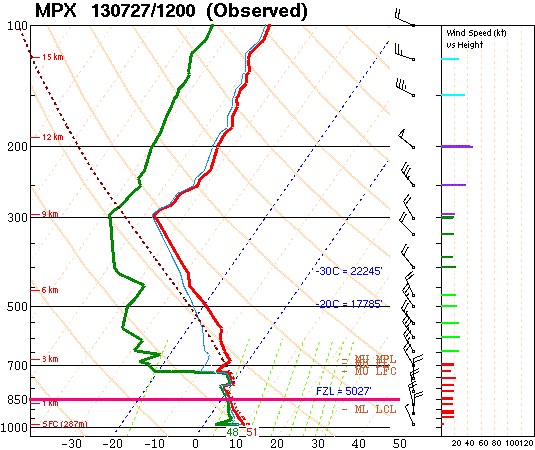
Here are the top 5 coldest temperatures recorded at 850 mb during the month of July at MPX/STC.

Foggy Bottom: Fall like river fog this morning
September and October are classic in Minnesota for "river fog." The still warm waters clash with colder air temps just above, and fog forms in the river valleys. Check out the GOES 1km visible satellite shot showing dense river fog on the Mississippi and Root Rivers this morning.

Today looks mild and dry in Minnesota. A weak upper air disturbance bring chances for showers Tuesday night and Wednesday, but rainfall looks generally spotty and on the lighter side...mostly under .25".

Kinder and gentler: Stuck on 75?
What meteorologists refer to as "northwest flow" aloft will bring slightly cool and generally drier than average weather over the next 7-10 days. Here's the Euro model take on temps and skies the next few days. Note the 24C...or 75F forecast high for several days running.
Image: Norwegian Met Institute
No 90s in sight yet... but warmer after August 10th?
It's hard to complain about plenty of sun and highs in the mid-70s anytime of the year in Minnesota. Our San Diego-like late summer cool swoon hangs in the next week to 10 days.

Our July cool snap can be partially blamed on a more "negative Arctic Oscillation" recently. There are signs that the upper air pattern could return to a more summery flow after about August 10th. Here's NOAA's "Arctic Oscillation" outlook. It indicated a more "positive" AO...which generally means warmer weather for Minnesota. It's too early to write off the potential for another 90 degree day or two just yet.

NWS supercomputers upgrade may boost forecast model accuracy. "Arms race" with Euro is on
What do you do when your forecast models lag behind the Europeans and several other nations in computing power and forecast accuracy? Buy some spiffy new supercomputers.
Thursday's NWS upgrade roughly doubles processing power to 213 "terra flops"...capable of performing 213 trillion calculations per second. That's still nowhere close to the Euro (ECMWF) capability...but another upgrade in 2015 could get NOAA close. The Europeans aren't sitting on their hands. They just announced a deal with computer giant Cray to buy 2 new supercomputers to stay ahead in the "NWP arms race."
Computerworld has a good write up.
The National Oceanic and Atmospheric Administration (NOAA) Thursday switched on two new supercomputers that are expected to improve weather forecasting.
The "go live" switch over to the new systems was made today without any fanfare, just a box of donuts on hand to mark 18 months of preparation and testing. The new IBM systems are now responsible for producing forecast data that's relied on in the U.S. and around the world.
The agency had planned to go live next Tuesday, but strong storms now in the Pacific and Atlantic Oceans prompted the decision to move the date up, said Ben Kyger, director of central operations at the National Centers for Environmental Prediction.
NOAA's National Weather Service (NWS) runs the two identical, or clone systems, one in Reston, Va., and in Orlando, Fla. They can switch over in about six minutes.
The supercomputers are each 213 teraflop systems, running a Linux operating system on Intel processors. The U.S. is paying about $20 million a year to operate the leased systems.
"These are the systems that are the origin of all the weather forecast you see," said Kyger. The computing system is called the Weather and Climate Operational Supercomputing System or WCOSS.