Best weather on the planet today; Weekend thunder; 90s return next week? Chantal flares overnight

"Perfect" Weather
The unscientific Weather Lab opinion poll is in...and this is the favorite weather pattern for the majority of Minnesotans.
If I had to put a number on it, in 30+ years of talking to Minnesotans about weather I'd have to say at least 70% would say temps in the low 80s, low humidity and fresh breezes are the "best weather" Minnesota has to offer.
"Good sleeping weather" is a kitschy Minnesota phrase for good reason.
Create a More Connected Minnesota
MPR News is your trusted resource for the news you need. With your support, MPR News brings accessible, courageous journalism and authentic conversation to everyone - free of paywalls and barriers. Your gift makes a difference.
Our perfect air mass last through Thursday. Dew points creep up on Friday and thunder returns this weekend. The trusty Euro model hints at 90s....maybe even mid-90s next week.
Tropical Storm Chantal is unusual in size, shape and speed. She may yet become a threat for heavy rains in the southeast USA.
In other news...did I mention it's really, really nice out there?

71F dew point at MSP at 8am Tuesday
56F dew point at MSP at 7 am today
[image]
Air mass exchange
Thanks to Canada for the fresh northwest breezes. Here's the GOES 1km visible satellite shot showing mainly clear skies...and northwest winds blowing in cooler air into Minnesota today. I've overlaid wind "streamlines" and temps.

Here's another perspective...and a really cool animated wind flow map courtesy of http://hint.fm/wind/. See how the winds spiral out from the center of high pressure in the Dakotas?

Destination Duluth?
Our northwest wind will be a warm one today along the North Shore.
Huh? Did I hear that right Paul? I thought northwest winds are cool/cold in Minnesota... right?
Yes, usually. But on the North Shore when the lake is cold (lake temps in upper 30s to 50s) a south or east wind is much colder in summer. today's northwest wind will blow from warmer land areas...and the "downslope warming" may add a few degrees by the lake at the bottom of "the hill."
Finally a nice day for the Northland!

48 hours of weather bliss?
Enjoy the fresh air and dew points in the 50s. They're headed back into the sticky 60s...to possibly 70F this weekend.

More moisture means on thing in summer. Thunderstorms. Here's the rainfall outlook for the weekend. There may be some hefty 2"+ totals with weekend downpours. Another potential free lawn watering?

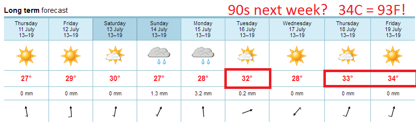
Euro: 90s return next week
Here's a number you should know. 32C.
That's 89.6F for us Americans....basically the 90F mark.
The Euro model is bumping a ridge of hot high pressure north next week. The result could be 1 to 3 days of 90F+ heat.
Tropical Storm Chantal: Overnight flare up
Chantal looked very disorganized...nearly on life support late Tuesday. Overnight Chantal's cloud shield flared with a huge circular convective burst.

Chantal continues to fight wind shear which is tearing at the storm and preventing further intensification so far. Forecast models show Chantal will have a tough time intensifying.

Wxunderground and Weather Channel hurricane expert Dr. Jeff Masters has more on why Chantal is unusual.
Unusual Tropical Storm Chantal has strengthened a bit more as it speeds west-northwestwards at 26 mph away from the the Lesser Antilles Islands. Sustained winds of 38 mph, gusting to 52 mph, were observed at Martinique at 10 am AST as the storm passed. However, an automated weather station at the airport measured sustained winds of 60 mph, gusting to 78 mph, according to an official with Meteo-France. The Associated Press reported that Chantal ripped the roofs off of several homes on neighboring Dominica.
An Air Force hurricane hunter aircraft measured top winds at their 1,000' flight level of 89 mph at 12:55 pm AST. Top winds seen by the aircraft's SFMR instrument were about 65 mph, in a small area east of Chantal's center. The Hurricane Hunters have departed Chantal, and the next plane is due in the storm at 8 pm EDT. Chantal's winds are unusually high considering the storm's high central pressure of 1006 mb and disorganized appearance on satellite imagery. Chantal is fighting dry air associated with the Saharan Air Layer (SAL), as seen on water vapor satellite loops. This dry air is creating strong thunderstorm downdrafts that are robbing Chantal of moisture and energy. Visible satellite loops show the outflow boundaries of these thunderstorm downdrafts at the surface, spreading to the northwest of Chantal.
Chantal's official NHC track takes her over Cuba...then near Florida as a tropical depression this weekend. But there is far more "spread" in the model spaghetti plots today.

Chantal may still hold a few surprises in the coming days.
Paul Huttner