Severe Risk Tuesday: Thundery warm front lifts north; (Why do some trees snap and some “uproot?”)
Thunder Threat Grows Again
It was a nice 2-day break from bright red radar blobs, thunder-induced sleep deprivation and shredded tree debris on your driveway.
As Minnesotans still clean up from the most widespread damaging wind event in several years, the next wave of rain and storms is moving north.
An active warm front sends another severe "bow echo" through Iowa and Chicago...then lifts north into Minnesota overnight. This time the severe risk stays mostly south overnight...but spreads over much of Minnesota by Tuesday PM/evening when another severe outbreak is possible.
Create a More Connected Minnesota
MPR News is your trusted resource for the news you need. With your support, MPR News brings accessible, courageous journalism and authentic conversation to everyone - free of paywalls and barriers. Your gift makes a difference.
The good news? Stormy skies begin to quiet down again later this week, and there are signs of a more tranquil, summer weather pattern with fewer stormy outbreaks in the next 1-2 weeks.
Tranquil and summer in the same sentence describing Minnesota weather. What a concept.

Severe Chicago: Bow echo blasts Chicagoland
The latest targets in the Midwest severe onslaught run from Iowa through Chicagoland. Another severe Mesoscale Convective System (MCS) raced across Iowa with 70mph winds and slammed into Chicagoland Monday evening. Just as the storms that raced through Minnesota last weekend, this one is shredding and downing trees along it's path.

Bow Echo with Leading Edge "Gustnadoes?"
Call it a Bow Echo on steroids. The Chicagoland bow featured possible "gustnadoes"... small scale vortices on the leading edge of the inbound gust front.
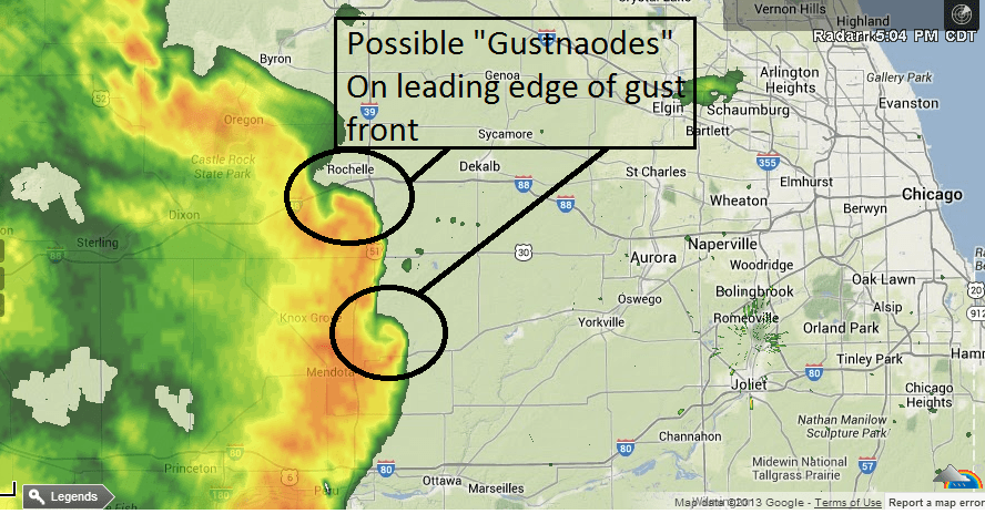
Gustnadoes can touch down and produce tornado damage as the larger gust front barrels through. Here are the latest storm reports from the Chicago NWS.
Minnesota: Scattered overnight & AM thunder
Look for more scattered showers & T-Storms overnight in southern Minnesota including the metro. The severe risk...and strongest storms with heavy downpours will favor the I-90 Corridor. A few of the storms could be strong in the metro toward AM rush Tuesday.
Severe Risk Tuesday:
As the warm front lifts north, the atmosphere over Minnesota will destabilize Tuesday afternoon and evening, That's the highest risk for severe storms...and another potentially damaging bow echo for central & southern Minnesota.

Expect the potential for more watches and warnings...and some damaging winds and hail especially late Tuesday PM & evening.

Tree Damage: Why do some snap and some uproot?
It's a question nobody want to have to ask, but everybody is asking now.
Why do some trees snap in half, or at the base or on a huge branch when others remain essentially intact as they are uprooted and slammed to the ground?
The answer seems to have more to do with local "tree geography" than the type of winds.
Once wind speeds reach about 70 mph as they did Friday night, significant tree damage kicks in. After that, how trees "fails" seems dependant on a variety of factors. Basically the wind will exploit the weakest spot in the tree.
-If there a hollow spot in the trunk the tree could snap there.
-If the tree was planted too deeply and has rotted around the base it may crack and fail at the base
-If a large branch is weak it may shear off
-If a tree is stronger and soils are wet like this past week, it may remain intact but be uprooted as the intense force of the wind on the tree canopy pulls out the tree by the roots
UM Forestry expert Dr. Lee Frelich has some great perspective from an interview with Steve John on All Things Considered Monday afternoon.
Lee Frelich, director of the Center for Forest Ecology at the University of Minnesota, spoke with Steven John of MPR News about what led to such extensive tree damage. An edited transcript of the conversation follows.
STEVEN JOHN: What was it about this storm that affected so many trees?
LEE FRELICH: The wind occurred over a wide area and apparently there were gusts in the range of 70-80 mph, and that's getting to the level where you can expect significant tree damage.
JOHN: Does the height and age of the tree determine whether or not it will come down?
FRELICH: Yes. Tall trees are sticking up there where the winds are higher. They have a bigger crown, or more sail for the wind to push on. Older trees, taller trees have thicker trunks that are less flexible.
If a tree isn't flexible in the wind, that puts all the force at the roots and so the tree is likely uproot or snapped off at the base.
JOHN: Does the wind pattern also determine whether a tree will topple?
FRELICH: The direction will often have a big influence on the outcome for a particular tree. If a tree is in a wind tunnel between building in the city and the wind happens to lined up with that. Or, for trees that are growing on city streets between the street and the sidewalk and so the roots are forced to grow in only two directions, and then a wind comes which is perpendicular to that and there are no roots holding the tree in that direction and the tree can tip over much more easily than if the wind was blowing parallel to the street.
JOHN: Does the type of soil make a difference?
FRELICH: Saturation of soil will allow the tree to sway back and forth in heavy winds and kind of jerk the root system. Usually the bigger roots will snap one at a time and eventually after several gusts of wind the tree will go over. When the soil is loose from being saturated that process is exaggerated, especially in soils that have a lot of silt and clay. In sandy soils, it's not such a big problem. The roots go down deeper in sandy soils and a lot of the excess rain drains away. We have a lot clay soils in Minneapolis. A lot of trees were uprooted for that reason.
JOHN: There are many species of trees that make up the urban canopy in Minneapolis. Is one more susceptible than the other to damage?
FRELICH: Basswood or linden trees had a lot of damage. Lindens tend to be hollow. We also have a long history of that species being planted too deep. A lot of ash trees went down for the same reason. Blue spruce get damaged because they have a shallow root system, so a lot of the time they don't hold on that strongly.
JOHN: Is there anything a homeowner can do to take better care of their trees so they're not so susceptible to damage during storms like these?
FRELICH: A lot of trees that blow down in urban areas are damaged in the wind because they weren't planted properly, especially trees that are planted too deep. This causes rot at the base of the trunk.
Trees that have girdling roots: If the tree was grown in a container in a nursery and has roots that go around in a circle - as those grow to bigger diameters it can actually choke off the base of the trunk and make it more likely to snap.
Hitting the tree with lawn movers or snow plows or other mechanical equipment can knock off a chunk of bark early in the tree's life and fungi that rot the tree can enter them. Many years later the tree can blow over and people don't even remember why it was that rot got into the tree.
JOHN: Was there anything surprising about this storm and the damage?
FRELICH: I was surprised to see how many trees weren't damaged. It was amazing to me that we have so many trees that withstand a heavy storm like that and come through it just fine and live for many more years. If the winds had been 100 or 110 mph it probably would have taken down the entire urban forest canopy. The winds were marginal in terms of doing major tree damage and I think we're very lucky.
Here's another interesting study form the journal Forestry on tree damage patterns in Hurricane Hugo and other storms in the Carolinas. Here's an excerpt.
Conclusions
Although wind speed is undoubtedly the most important factor for predicting tree damage, to date it has only been quantified at the spatial scale of a region and a temporal scale of 1-min averages. Fine-scale spatiotemporal variability in wind speeds is undoubtedly important in accounting for patterns in tree damage and is presumably responsible for the large amount of unexplained variation in wind disturbance models. Second to wind speed, tree size is consistently found to be a major predictor of damage severity with large trees being associated with a high risk of uprooting or breakage. Landscape-scale analyses show relatively predicable patterns controlled by a combination of topographic position, and stand height, in contrast to stand-level patterns, which can be understood only in the context of tree size, species and possibly other individual tree characteristics.
Certain variables are appropriate for predicting damage only at certain spatial scales: meteorological variables at the regional scale, site and community variables at the landscape scale and tree variables at the stand scale. However, variables observed at finer scales can be integrated into broader-scale studies, providing greater ability to predict tree or stand damage. Thus, our ability to predict tree damage increases with spatial scale, suggesting the importance of examining broad geographical patterns when assessing risk factors for broad-scale disturbances such as windstorms.
Here's hoping your trees stay intact through Tuesday night, as the weather begins to mellow later this week.
The longer range pattern suggests a slow down in storms over the next 1-2 weeks. Here's a rare and welcome sight...an outlook favoring below average rainfall fro a soggy Minnesota in the 6-10 day window from NOAA.

Paul Huttner