Winter Storm shifts south: Metro now in 5″ to 10″ heavy snow zone?
-Updated 5:40pm-
A quick update for Saturday evening.
The Saturday PM (18z) model runs show a distinct trend toward shifting the storm track south...and potentially putting the metro into the heavier snowfall zone. Take a look at the increase in liquid totals for MSP from the morning (12z) to afternoon (18z) model runs.
NAM: .48" to .75"
Create a More Connected Minnesota
MPR News is your trusted resource for the news you need. With your support, MPR News brings accessible, courageous journalism and authentic conversation to everyone - free of paywalls and barriers. Your gift makes a difference.
GFS: .62" to 1.00"
If the trend on the 18z runs is accurate, that represents a major increase in snowfall totals for the metro...an additional 2" to 4" at least.
Based on these trends, I am now upgrading my snowfall forecast for the metro to 5" to 10" by Sunday evening. Snow may continue through much of Sunday if the latest storm trends hold.
Image: NOAA GFS via wxcaster.com
Image: Iowa State University
Craig Edwards will have the latest trends early Sunday morning on Updraft and MPR News.
PH
Winter Storm Warnings in effect from the Twin Cities north
Blizzard Warnings for western Minnesota
Snow increasing from west to east across Minnesota tonight
-Latest Twin Cities radar loop
9pm to midnight snowfall approaching metro from the west
1/4S+ Heavy snow with visibility of 1/4 mile reported in Huron, SD Saturday afternoon (That's a snowfall rate of 1"+ per hour)
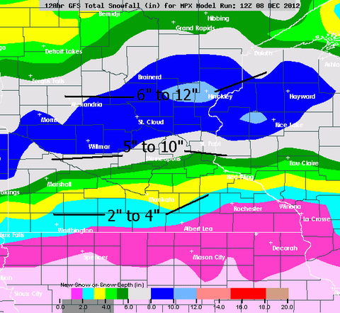
5" to 10" overall snowfall range for the metro by Sunday evening
2" to 4" for southern Minnesota including I-90 corridor & Rochester
6" to 12" for much of central and northern Minnesota by Sunday night
(Includes Alex, St. Cloud, Brainerd, Iron Range, Duluth & North Shore communities)
Image: Twin Cities NWS
Here it comes:
It may not be a "snowpacolypse" or "snowmageddon"... but the winter storm moving through Minnesota this weekend will be the 1st significant storm of the season for the metro.
The last model runs are in before the snow flies, and my latest thinking on the storm is the same. Some highlights and specifics.
Timing: Snow spreads across western Minnesota Saturday evening, and reaches the metro most likely between 9pm and midnight. A few models hold off metro snow until after midnight.
Snowfall will be heaviest overnight into Sunday.
Storm Character: This looks to be a quick hitting snow event. Once the snowfall begins at your location, snowfall intensity and rates should pick up pretty quickly. Visibilities between 1/2 mile and 1/4 mile in moderate to heavy snow are common in the Dakotas as the system rolls through.
The heaviest snowfall rates for the metro will come through overnight into Sunday. We could see some 1/2 mi to 1/4 mi visibilities with big fat flakes in heavy snow (S+) reports in the metro in the wee hours Sunday.
Thundersnow? The system has enough strong "lift" or upward vertical velocity (UVV) that it will generate strong updrafts and has the capacity to produce a few small scale embedded thunderstorms. A lightning flash and clap of thunder in a "snowburst" is not out of the question overnight or Sunday!
Snowfall totals: After a slight northward shift Friday night, Saturday's model trends bumped the system back just a little to the south.
The 12z models cranked out some decent metro liquid precip totals.
NAM .47"
Euro .59"
GFS .60"
The 18z modles increased the moisture. Based on the PM runs, my thinking on snowfall has increased snowfall totals for the metro..
2" to 4" in southern Minnesota including the I-90 corridor cities
5" to 10" overall metro range. Best chance of 10" on your driveway by Sunday evening in the north metro.
6" to 12" "up north" including Alex, St. Cloud, Brainerd, Iron Range Cities, Duluth & North Shore.
Wind: Strong winds will kick in for western Minnesota Sunday. Blizzard warnings are flying for the Dakotas, and western Minnesota. Expect severe blowing and drifting snow out west as winds over 40mph whip the snow around and drift over roadways.
Image: NOAA
Interestingly, NWS has increased snowfall totals for the metro in their late Saturday PM forecast update.
HENNEPIN-ANOKA-RAMSEY-WASHINGTON-CARVER-POLK-BARRON-RUSK-
ST. CROIX-INCLUDING THE CITIES OF...MINNEAPOLIS...BLAINE...ST. PAUL...
STILLWATER...CHASKA...AMERY...BALSAM LAKE...RICE LAKE...BARRON...
LADYSMITH...HUDSON...NEW RICHMOND
336 PM CST SAT DEC 8 2012
...WINTER STORM WARNING REMAINS IN EFFECT FROM MIDNIGHT TONIGHT TO MIDNIGHT CST SUNDAY NIGHT...
* TIMING...SNOW...HEAVY AT TIMES...WILL DEVELOP AROUND MIDNIGHT AND CONTINUE OCCASIONALLY THROUGH SUNDAY BEFORE TAPERING OFF SUNDAY EVENING.
SNOW ACCUMULATIONS... 6 TO 9 INCHES ...WITH THE HEAVIEST AMOUNTS NORTH OF INTERSTATE 94.
* OTHER IMPACTS...AREAS OF BLOWING AND DRIFTING SNOW ARE EXPECTED SUNDAY AFTERNOON AND EVENING AS NORTHWEST WINDS INCREASE TO 15 TO 25 MPH AND GUST UP TO 35 MPH.
Overall this will be a "productive" winter storm for Minnesota. Expect the usual "winter storm" travel conditions Sunday.
Let it snow!
PH