Glistening snowfall great for recreation
Snow during the past 24 to 36 hours accumulated around 2 inches in the Twin Cities with amounts of 4 inches extending from Sioux Falls, SD to La Crosse, Wis. and on east to the Wisconsin Dells.
A nice snowfall occurred in the Arrowhead region of Minnesota and in Bayfield County, Wisconsin as well. Snowfall reports from Duluth can be seen here.
Snowfall reports for the region can be found here.
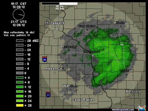
Late this afternoon, radar continued to paint a nice swath of snow through central Wisconsin.
Create a More Connected Minnesota
MPR News is your trusted resource for the news you need. With your support, MPR News brings accessible, courageous journalism and authentic conversation to everyone - free of paywalls and barriers. Your gift makes a difference.
Snapshot of La Crosse radar. Source:NOAA/Weather Underground
Roads, including Interstates 90 and 94 in Wisconsin, are slick and snow-covered in spots.
Please be cautious when traveling east and south through Wisconsin this evening.
Click here for the Wisconsin road report.
Snow has been hard to come by from St. Louis to Chicago and in the Red River Valley, but a good portion of the landscape has a nice snowcover heading into the last weekend of 2012. Another 3 to 5 inches of fresh snow are possible from southern Indiana through Pennsylvania later tonight and Saturday.
Snow depth December 28. Source:NOAA
Somewhat below seasonal temperatures are expected as we close out December 2012. We'll ring in the New Year with a crisp morning.
Low temperatures forecast for Monday night. Source:NWS
There doesn't appear to be any big snowstorms looming in our future. The cold air mass is expected to moderate later next week.
Enjoy your weekend. Paul will be back on Monday.
Craig Edwards