Why Minnesota is “high impact” for climate change; 60s return Saturday?
35th year in a row above 20th century global temperature average
45% of land use on earth has changed in past 100 years
53% of USA's residents live in "oceanfront counties"
"Weather" is the new "Fire" Insurance companies in Canada have paid more for weather losses than fire losses in the past 10 years for the first time ever
Create a More Connected Minnesota
MPR News is your trusted resource for the news you need. With your support, MPR News brings accessible, courageous journalism and authentic conversation to everyone - free of paywalls and barriers. Your gift makes a difference.
March 2012 heatwave most anomalous extreme heat event in North American history
"Quickening" Climate is changing so quickly that climate "normals" are less valuable as predictors of future climate
6-10 years Look at last 6-10 years to best predict future climate trends
Minnesota near ground zero? Greatest warming signal occurring in center of continents...less near oceans
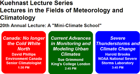
Illuminating Kuehnast Lecture Thursday:
I was fortunate to hear an excellent group of speakers at the 20th Annual Kuehnast Lecture series event Thursday PM at the UM.
Environment Canada's (Canada's NWS) Senior Climatologist David Phillips gave one of the most interesting and relevant talks for Minnesota.
Dr. Mark Seeley with Senior Climatologist David Phillips from Environment Canada
Photo: Paul Huttner-MPR News
Most of the tidbits at the top of this post are direct quotes or my notes from David's talk.
The bottom line?
Minnesota seems to be near the epicenter of some of the greatest observed warming in North America.
Here's why:
-The greatest observed warming signal is occurring in center of continents...less near oceans
-There appears to be more warming in western and southern Canada...essentially closer to Minnesota
-The observed warming trends in Canada support the trends of warmer winters...and especially winter nights we've seen in Minnesota
It's interesting to see that the trends being observed in Canada closely mirror what we're seeing in Minnesota.
-Increase in extreme weather events in Canada
-Worst drought followed by worst floods in 100+ years
-1st F5 tornado, worst wildfires on record
-Lakes & rivers freezing 2-3 weeks later in fall and thawing earlier in spring
Shorter "freezing seasons" and changing migration patterns are having pronounced effects in the far north.
-Permafrost changes upsetting & damaging roads, homes & pipelines
-Inuit peoples needed to add dragonflies & robins to their language because they had never seen them before!
David talked about the concept of "climate stress" - what happens when you put warming pressure on a climate?
-You change the climate...you change the weather
-"Stress" the climate and you get more extreme weather
-We base society on "normal" wx...but we're living extremes
The notion that climate in Canada & elsewhere is changing so fast...that our climate "normals" do not accurately reflect future climate is astounding.
-We're already observing dramatic changes after only 1F warming
-What happens when we see another 2-4 F in the next 30-50 years?
-CO2 in atmosphere is already preloaded for warming...we will need to embrace adaptation now
-Build more resilient communities, build infrastructure defenses against future floods, droughts extreme weather...backwater valves cost $150, but can save thousands in flood damage, increase runoff capacity etc.
Thursday's event was eye opening and will be posted online in the near future if you're interested in taking a look.
Milder days ahead:
Low pressure will push out of the Rockies into Minnesota by Saturday.
Ahead of the low, milder air will ride north Saturday, and temps may crack the 60s from the metro south Saturday PM.
A much colder front will bring rain...and even some accumulating snow to western & northern Minnesota Saturday night & Sunday.
We'll all feel a much colder shot of air Sunday as the cold front sweeps through.
PH