Overnight precipitation heading into Wisconsin; breezy western Minnesota
Precipitation spread from west to east overnight and is now confined to northeast Minnesota and far southeast Minnesota. Look for mainly dry weather across the state as we go through Election Day.
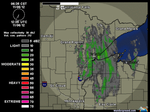
635 a.m. CST radar screen capture. Precipitation falling as snow mixed with some rain.
Source: NOAA/Weather Underground
Create a More Connected Minnesota
MPR News is your trusted resource for the news you need. With your support, MPR News brings accessible, courageous journalism and authentic conversation to everyone - free of paywalls and barriers. Your gift makes a difference.
Rain was steadily progressing across western Wisonsin this morning.
640 a.m. CST radar image depicting moderate rain in yellow.
Source:NOAA/Weather Underground
Happy to report that rainfall tallied more than a quarter inch in portions of the Twin Cities overnight. The Twin Cities International Airport measured 0.30 inches of rainfall. I captured nearly a quarter inch in my rain gauge at the Eden Prairie weather center.
Snow mixed with rain in northeast Minnesota delivered about two tenths of an inch of moisture.
NOAA Water Vapor Satellite image this just before sunrise shows the enhanced clouds from our weather maker moving into Wisconsin and Illinois. The storm that we have been monitoring to potentially effect the northeast US is just starting to take shape off the South Carolina coast.
Election Day temperatures in our neck of the woods will be seasonal, but expect gusty winds in western Minnesota through the afternoon.
Maximum temperatures for Tuesday. Source: NOAA/NWS
Winds will not be as gusty in eastern Minnesota today.
Source; NOAA/NWS
Currently there continues to be some slight differences in the model data for the northeast track of the storm along the east coast. Some agreement suggest that the center of lowest pressure will stay off shore as it skirts New York Wednesday night.
Pressure pattern and six hour precipitation at 1 a.m. EST Thursday morning from the NAM. Source: NOAA/NWS and College of Dupage
After a couple of quiet days things start to warm up and get interesting on Satuday as a storm system takes shape in Nebraska on Friday night. A surge of very warm air into Minnesota could trigger some showers and thunderstorms on Saturday.
Source: NOAA/College of Dupage.
Surface pressure and temperatures from GFS model for noon local time on Saturday. Note the sixty degree tempreratures over much of central and southern Minnesota.
Much cooler weather arrives on Sunday.
Craig Edwards