Pattern Change: Cooler air pooling north; More 70s than 90s next 2 weeks
78 high at MSP Airport Saturday
76 high at MSP Sunday
1st back to back days in the 70s since June 13th & 14th
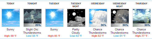
Quick look metro forecast:
Create a More Connected Minnesota
MPR News is your trusted resource for the news you need. With your support, MPR News brings accessible, courageous journalism and authentic conversation to everyone - free of paywalls and barriers. Your gift makes a difference.
Source: Twin Cities NWS
82 average high at MSP now
39 days in a row at or above 80 in the metro this summer until Saturday
(Ties the longest stretch of 80+ days at MSP set in 1916)
26 days at or above 90 degrees so far in 2012
27 days of 90+ heat in 2007 (last time we felt this many 90 degree days)
39F at Mayo in Yukon Territory this morning
Cooler air pooling in the Yukon & northern Canada this week
More 70s than 90s ahead for Minnesota the next 2 weeks
Signs of climate change in Yellowstone National Park
MPR Weather Guy high atop 10,243 foot Mt. Washburn in Yellowstone National park last week.
Photo by Luke Huttner
Back to MPR Land:
It's good to be back in Minnesota after a great vacation last week. We logged some serious road miles driving to Yellowstone and Grand Teton National Parks last week. That trip reminds you how vast and beautiful the American West really is.
I saw distinct signs of climate change in the Black Hills and in Wyoming since my last visit there 18 years ago. More on that later this week. It's good to be back in Minnesota!
Worst of summer heat now over: Fall preview ahead
The weather maps look very different than when I left Minnesota 11 days ago.
The major "heat pump" high pressure dome that has baked the Midwest this summer has buckled and shifted into the western states. That opens the door for "northwest flow" over Minnesota, and will bring a series of cooler Canadian Air masses the next two weeks.
Source: NOAA
Looking ahead, it looks like we'll see far more days in the 70s the next 2 weeks than 90 degree highs. In fact, we'll make a run at 90 today in southern Minnesota (I'm forecasting 89 at MSP) and that may be the only day in the next 2 weeks we have a shot at 90 at MSP Airport.
Source: NOAA via Iowa State University
We're sitting at 26 days at or above 90 right now at MSP for 2012. That's the most in 5 years since we logged 27 in 2007. Looking out ahead 2 weeks, it's likely we'll only add one more day at most of 90 degree heat.
Cooler than average August?
Now that would be a headline if it verifies!
Much cooler air is pooling now in the Yukon Territory and northern Canada. It was a crisp 39 degrees this morning at Mayo in the Yukon Territory.
Source: Evironment Canada
That sounds like it's a long way from Minnesota, but the upcoming shift to northwest flow will bring cooler air to Minnesota later this week. The GFS is advertising high only in the (gulp!) 60s by the weekend of August 18th. I won't be shocked to see upper 30s and scattered frost in the colder nooks and crannies of northeast Minnesota by the weekend of August 18th.
Take a look at the 14 day outlook from NOAA's Climate Prediction Center. Notice the absence of warmer than average odds for Minnesota? I expect the map will change color to blue, and favor cooler than average temps for Minnesota when CPC next updates this map.
Source: NOAA/CPC
By many measures, this last 12 months have been the warmest ever recorded in Minnesota and the USA.
We just logged the 14th straight month of (significantly) above average temps in Minnesota.
The weather pattern looks much cooler, and even cooler than average the next 2 weeks. If we manage to have a cooler than average August, it will be the 1st cooler than average month in Minnesota since May 2011!
Warm streak ends?
July ran +6.4 degrees at MSP Airport. The Twin Cities NWS expands on our warm streak.
July of 2012 will likely be remembered for near record warmth. July continued a long standing trend of seeing above normal temperatures across the area, with most locations seeing temperatures 5 to 7 degrees above normal. In fact, this marks the 15th consecutive month that all three climate locations have seen above normal temperatures. One has to go way back to May of 2011 to find a month where the average temperature for the month was below normal at all three locations.
For the Twin Cities...here's a look at the departure from normal for the average monthly temperature, and its historical ranking, back to June of 2011.
Month/ Temperature Departure from Normal/ Rank
July 6.4 2nd warmest
June 3.5 10th warmest
May 4.5 11th warmest
April 2.5 23rd warmest
March 15.5 1st
February 6.8 13th warmest
January 7.7 8th warmest
December 8.1 13th warmest
November 5.6 9th warmest
October 6.5 9th warmest
September 0.9 42nd warmest
August 2.4 19th warmest
July 2011 5.6 6th warmest
June 2011 1.1 40th warmest
String of 80s Ends:
Details on the end to our record tying stretch of 39 days at or above 80 in the metro from Twin Cities NWS.
A string of consecutive 80 degree or higher maximum temperature readings at Minneapolis, St Cloud and Eau Claire Airports was stopped dead in its tracks on Saturday by the passage of a strong cold front. Cold air emanating from the provinces of Alberta and Saskatchewan put the brakes on a string of warm weather that began as early as the last week of June in both Minneapolis and St. Cloud. Minneapolis actually tied the all time record set way back in 1916.
Source: Twin Cities NWS
Welcome to Omaha!
If you average temperatures for the past 13 months in Minnesota we're running about +6 degrees vs. average since last July. That level of departure from normal means the average Twin Cities temp has been about the same as Omaha, Nebraska for the past year.
If you've ever wondered what it's like to live in Omaha's climate, now you know. Omaha's weather came to the Twin Citiesin the past 13 months.
PH