Brief wintery rerun today; New signs point to a warm spring ahead!
60 degrees at MSP Airport Tuesday!
+24 degrees vs. average
+2.2 degrees vs. average so far in March
10th straight month warmer than average in Minnesota?
Create a More Connected Minnesota
MPR News is your trusted resource for the news you need. With your support, MPR News brings accessible, courageous journalism and authentic conversation to everyone - free of paywalls and barriers. Your gift makes a difference.
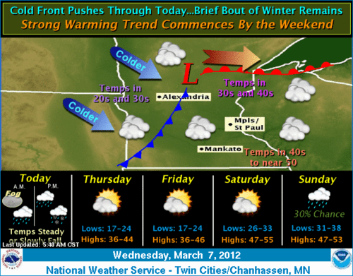
Cold front today brings falling temps
Rain and snow showers today behind the front
60s return this weekend?
Warm spring ahead?
Cold Front today!
Our April flirtation is history, at least for a couple of days.
A cold front is sliding southeast today, and temps are dropping behind the front. Look for scattered rain and snow showers as temps fall today back into the 30s in most areas by later today.
Signs of a warm (and wet) spring?
Many signs point to a warm and potentially wet spring for Minnesota. That could be just what the doctor ordered for easing the drought which developed rapidly last fall.
Here are a few of the meteorological tea leaves that point to a mild, potentially wet spring.
1) Mild March looks almost certain now.
There's every reason to believe the mild forecasts will pan out for March at this point. Looking at the maps, it's as if something is "broken" compared to what we would usually expect in March in Minnesota. The jet stream is well north into Canada, when it is usually howling overhead this time of year delivering one snow storm after another.
Tuesday's and today's above average warmth means we're already running a good +2 degrees vs. average in the metro so far in March.
The overall weather pattern for the next 16 days looks unseasonably mild. The GFS for example is cranking out temps roughly +15 degrees vs. average overall the next two weeks. Medium range forecast models may have difficulty with pinpointing individual storms a week or two out, but they're usually much better with overall temperatures trends.
GFS Model cranks out unseasonably mild temps and rainfall the next 16 days!
It looks like March will be the 10th straight month above average in Minnesota, dating back to last June.
2) The relative lack of snow cover now in southern Minnesota, and the shrinking snow pack up north increase the odds of a warm month.
We melted 2"+ of snow Tuesday in Minnesota. All signs say the melt will resume/continue by this weekend.
Without snow, nearly all of the sun's energy goes into warming the air instead of meting snow. Any southerly winds can readily blow in warmer air from Iowa and southern Minnesota now.
That means temps can run a good 10-15 degrees warmer over bare ground than on dwindling snow covered areas.
3) Climate "drivers" favor a milder spring.
Assuming a mild March, we're 1/3 of the way toward a mild "meteorological spring."
(Mar-May)
Several factors point to odds of a milder spring than last year in Minnesota.
-Fading La Nina: Last spring featured a strong La Nina which can favor cooler spring in Minnesota. This year La Nina is fading/gone.
[image]
More red and less blue means warming Pacific ocean temps
-AO still positive: The positive phase of the Arctic Oscillation gave us a mild winter. It appears it may linger overall this spring.
-NOAA outlooks favor a warm spring for Minnesota and the eastern USA.
A warm dry spring in Minnesota would be bad news for Minnesota's drought. At least in March, jet stream pattern seem to favor higher than average rainfall, and that could mean several rainy/thundery episodes this month and potentially this spring.
The GFS is still hinting now (for several runs) at rainfall exceeding 2" for much of southern Minnesota in the next 16 days.
That would be a good start to washing snow cover and rainfall runoff into our woefully low lakes and rivers this spring.
Let's see what unfolds this spring, but tat this point...it looks like an early and warm spring in Minnesota this year!
PH