BWCA smoke thick in Milwaukee & Chicago. To MSP Wednesday?
Update 7:00pm: Latest fire maps...smoke plume causing health problems in Chicago, some smoke may arrive in the Twin Cities metro area Wednesday!
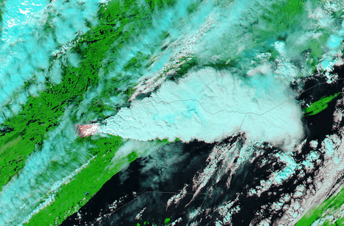
Pagami Creek Fire smoke plume explodes Monday on NASA MODIS Terra Satellite image.
(Courtesy UW CIMSS Satellite blog)
Create a More Connected Minnesota
MPR News is your trusted resource for the news you need. With your support, MPR News brings accessible, courageous journalism and authentic conversation to everyone - free of paywalls and barriers. Your gift makes a difference.
The latest maps showing the areas burned by the Pagami Creek Fire are heartbreaking to me as a seasoned BWCAW traveler. Some of the most popular, beautiful and valuable wilderness canoe routes have now been charred according to the latest fire maps.
On the map below you can see the fire perimeter now includes the route through the popular "numbered lakes" (One through Four) into Hudson and Insula Lakes. You can see a large and detailed map here.
This route is one of the most travelled in the BWCA. I paddled this route last August from the beautiful Kawishiwi Lodge on Lake One.
Here are some photos of the beauty that is Lake Insula.
Early morning view from a campsite on Lake Insula.
My son Luke soaks up the view to the south. Much of this view may now be charred landscape.
Huttner family soaks up the scenery from our own private island campsite. The latest fire maps show the burn area close to this island.
Smoke causing health problems in Milwaukee & Chicago!
WGN webcam image shows thick smoke in Chicago Tuesday.
[image]
Thick smoke is hanging low as far away as Chicago Tuesday evening.
@MPRweather they've closed the roof at the #Brewers-#Rockies game at Miller Park b/c of the smoke!
Here's the statement form the Chicago NWS. Air quality alerts have been issued in Milwaukee!
SPECIAL WEATHER STATEMENT
NATIONAL WEATHER SERVICE CHICAGO IL
205 PM CDT TUE SEP 13 2011
INCLUDING THE CITIES OF...ROCKFORD...BELVIDERE...WOODSTOCK...
WAUKEGAN...OREGON...DIXON...DEKALB...AURORA...WHEATON...CHICAGO...
OTTAWA...OSWEGO...MORRIS...JOLIET...KANKAKEE...PONTIAC...
WATSEKA...PAXTON...GARY...VALPARAISO...MOROCCO...RENSSELAER...
FOWLER
205 PM CDT TUE SEP 13 2011 /305 PM EDT TUE SEP 13 2011/
...SMOKE FROM NORTHEASTERN MINNESOTA WILD FIRE SPREADING INTO NORTHERN ILLINOIS...
SMOKE FROM A LARGE WILDFIRE OVER NORTHEAST MINNESOTA HAS BEEN MOVING INTO FAR NORTHERN ILLINOIS THIS AFTERNOON...DUE TO
NORTHERLY WINDS BEHIND A COLD FRONT WHICH MOVED ACROSS THE AREA EARLY THIS MORNING. ALTHOUGH THE FIRE IS MORE THAN 400 MILES NORTHWEST OF THE AREA...THE COMBINATION OF SINKING AIR AND NORTHERLY WINDS BEHIND THE FRONT HAS TRANSPORTED SMOKE ALL THE WAY INTO NORTHERN ILLINOIS. THE SMOKE WILL LIKELY PERSIST THROUGH THE AFTERNOON AND INTO THE OVERNIGHT HOURS...BEFORE WINDS BECOME MORE WESTERLY IN ADVANCE OF ANOTHER COLD FRONT WHICH WILL APPROACH EARLY WEDNESDAY MORNING. SMOKE WILL LIKELY CONTINUE TO SPREAD TO
THE SOUTHEAST ACROSS MUCH OF NORTHEAST ILLINOIS AND NORTHWEST INDIANA THROUGH THIS EVENING. EXPECT HAZY SKIES AND A DISTINCT BURNING ODOR.
THE LAKE COUNTY ILLINOIS EMERGENCY MANAGER REPORTS THAT SMOKE IS PREVALENT ENOUGH TO CAUSE PEOPLE TO REPORT DIFFICULTY BREATHING AND BURNING OF THEIR EYES.
INDIVIDUALS WITH RESPIRATORY PROBLEMS SHOULD USE CAUTION WHILE SMOKE AFFECTS THE AREA.
And in Milwaukee...
554 PM CDT TUE SEP 13 2011
...AIR QUALITY ADVISORY ISSUED FOR THE COUNTIES OF DODGE...
WAUKESHA.... MILWAUKEE...RACINE AND KENOSHA
THIS AIR QUALITY ADVISORY IS BEING ISSUED DUE TO THE SUBSTANTIAL
INCREASE IN LEVELS OF FINE PARTICULATES IN SOUTHEASTERN WISCONSIN FROM A FOREST FIRE SMOKE PLUME EMANATING FROM NORTHEASTERN MINNESOTA.
THE WISCONSIN DEPARTMENT OF NATURAL RESOURCES HAS ISSUED AN AIR QUALITY ADVISORY FOR FINE PARTICULATES WHICH WILL REMAIN IN EFFECT UNTIL 11 AM TOMORROW. THIS ADVISORY AFFECTS THE PEOPLE LIVING IN THE COUNTIES OF DODGE...WAUKESHA....MILWAUKEE...RACINE
AND KENOSHA.
THE AIR QUALITY INDEX WILL SOON REACH THE UNHEALTHY LEVEL FOR
PEOPLE IN SENSITIVE GROUPS INCLUDING CHILDREN... ELDERLY PEOPLE...
INDIVIDUALS WITH RESPIRATORY AND CARDIAC PROBLEMS...OR ANYONE
ENGAGED IN STRENUOUS OUTDOOR ACTIVITIES FOR A PROLONGED PERIOD OFTIME.
Visibilities dropped from 10 miles to as low as 2.5 miles near Lake Michigan Tuesday in Milwaukee and Chicago.
The map from my former workplace in Chicago, WGN TV.
Smoke reduced visibility to 2.5 miles in Milwaukee Tuesday.
In addition a lake breeze front forced the smoke to descend to near ground level, creating what's known as a "trapping effect." This made it hard to breathe the concentrated smoke plume in Lake County north of Chicago.
The story from the WGN Weather Center:
Forest fire smoke plume being forced to the surface by cold front and lake breeze
"September 13, 2011 4:22 PM |
A forest fire that was ignited by lightning over far northern Minnesota on August 18th has sent smoke plumes south into Wisconsin and Illinois on a strengthening northerly flow.
The majority of the smoke from this fire has gone relatively unnoticed across the Midwest, drifting aloft between 3000 and10,000 feet. Unnoticed until today, when the combination of a cold front and a lake breeze forced the smoke to the surface, dropping visibility at times to 2 miles.
The lowest visibility is along and near the lake, from Milwaukee to Chicago, where a "lake breeze circulation" has developed this afternoon. This circulation forces air to sink over the lake, driving the thickest smoke, residing at 3000 to 5000 feet, down to the surface. Developing northeast winds are now sending that smoke inland, into Chicago, northeast Illinois and southeast Wisconsin."
Smoke plume may reach Twin Cities Wednesday:
So far the wind trajectories have pushed the smoke plume east of the Twin Cities. That may change Wednesday.
A secondary cold front will shift winds more into the north and northeast, instead of the northwest. This may push smoke southward toward the Twin Cities metro by Wednesday.
It remains to be seen how thick the smoke may be, but expect to see some increase in smoke in the metro by later Wednesday into Thursday.
PH
Update 3:15pm: Smoke now reported in Milwaukee, & Chicago suburbs!
NASA MODIS Terra image taken Tuesday clearly shows smoke plume from Pagami Creek Fire reaching Milwaukee and Chicago.
Smoky sky clearly visible in along the Chicago Lakefront from the web cam at the Field Museum of natural History.
I'm getting calls from relatives now in the northern Chicago suburbs that smoke is in the air. Here are some of the numerous comments from Updraft that confirm (thick) smoke has travelled as much as 500 miles!
"While driving, I thought there was something wrong with my sunglasses.
But sure enough, it was smoke and I work in Schaumburg (25 miles NW of Chicago).
Commenter name: Dan
I live in Delafield, WI (about thirty miles west of Milwaukee) and I could smell it at 8 this morning. At first I thought someone in our neighborhood was burning trash, but when I got to my college in
Pewaukee, I could smell it there, too. One of my teachers said
something about smoke from Long Lake covering most of Wisconsin. I couldn't believe it! That's crazy! But the smell is strange. It doesn't smell like trees burning, it smells like garbage.
Commenter name: Emma E
I work in Waukegan, IL and it is hazy and we can smell the smoke.
Commenter name: RobinT
Smoke has reached the metropolitan Milwaukee area. I first noticed smoke and the smell of burning wood around 10:30 a.m. (west of MKE). I thought a neighbor was taking advantage of today being a "burn day" in our city.
I have family near Ely ... I can't imagine how it must be up there.
Commenter name: Elizabeth F
We have smoke in West Bend, WI. You can even smell it inside the office. Looking outside you can see smoke haze. I have also hear it is getting bad in Germantown, WI. Didn't notice it when I got up this morning (Tues Sept 13) , but we sure have it now.
Commenter name: P Koenings"
Awoke several times Monday night smelling smoke. Checked house and even walked up neighbor's driveway to make sure she was OK. By 5 am, smoke was so strong and acrid, we had to shut the windows.
Began driving around to make sure other neighbors' houses and barns were OK.
Finally heard on local (Door County, WI) radio station that reports of smoke smell had been coming in from around the county all night, and that the smoke was from a forest fire in Minnesota. Shocking and sad!
Commenter name: J. Hughes
Update 9:30am:Smoke plume moving into Grand Marais again
As winds increase and shift into the west, the smoke plume is sweeping northward and pushing into Grand Marais again Tuesday morning.
Here's the shot from the Grand Marais Harbor Cam at 9:15am Tuesday. You can clearly see the smoky white tint to the sky looking south.
Here's the GOES 1km visible satelltie image at 9:15am. I've put an oval around the fire plume, and laid streamlines indicating surface wind flow in yellow over the top. You can see how the plume is getting pushed to the North Shore near Grand Marais...then fanning out across Lake Superior.
Smoke reports are coming in from as far away as Green Bay!
Update 8am Tuesday:
Here's an email I received overnight from Roger Nyquist with the Kawishiwi Lodge on Lake One. There are indications the Pagami Creek Fire blew up to as large as 70,000 acres Monday.
"Hello Paul, I work for Kawishiwi Lodge which is located on Lake One. I have been working on the end of the Fernberg Road on and off since 1999. The latest word from the News conference in Isabella is that the fire has spread 16 miles east in only 8 hours today!! Mark Van Every ( Kawishiwi Forest District Ranger) himself said this tonight.
That puts the total fire area at 70,000 acres and going strong! We have sent out 20 of our canoes full of D.N.R. and Forest Service employees from all parts of the country. The plumes of smoke and fire are visible from the lodge and surrounding areas. The fire is not going to die easy! This thing is a beast! It keeps jumping ahead and then filling in behind itself. Stop on by Kawishiwi Lodge next time you come up this way eh!"
We should get confirmation of the new number of acres this morning, but that acerage would not surprise me given the wind and fire conditions Monday.
Here's the Civil Emergency Message issued by NWS Duluth last night.
CIVIL EMERGENCY MESSAGE
LAKE COUNTY SHERIFFS OFFICE
RELAYED BY NATIONAL WEATHER SERVICE DULUTH MN
559 PM CDT MON SEP 12 2011
THE FOLLOWING MESSAGE IS TRANSMITTED AT THE REQUEST OF THE LAKE COUNTY SHERIFFS OFFICE.
DUE TO THE PAGAMI CREEK FIRE...AN EVACUATION HAS BEEN ORDERED BY
LAKE COUNTY SHERIFFS OFFICE. THE ORDER IS FOR LAKE COUNTY ROAD 7...CRAMER ROAD FROM FOUR MILE GRADE NORTH TO KAWISHIWI LAKE...AND WANLESS ROAD FROM COUNTY ROAD 7 WEST TO HOMESTEAD LAKE.
A PUBLIC MEETING WILL BE HELD TONIGHT AT 7 PM AT THE ISABELLA
COMMUNITY CENTER TO UPDATE RESIDENTS ON THE STATUS OF THE FIRE AND FUTURE PRECAUTIONARY EVACUATIONS. FOR MORE INFORMATION, CONTACT
2 1 8 3 6 5 3 1 7 7.
$$
MELDE
And check out this spectacular photo of the fire's billowing smoke plume from Carl Karasti via the Duluth NWS.
Here is the plume this morning as seen from from the GOES satellite 1km visible image. You can see the plume as reached the Wisconsin shores of Lake Superior, where reports of smoke and smoky smell are pouring in.
Here's a more detailed map of the fire as of Sunday.
And some more photos of the fire from USFS aircraft.
PH
Update 6pm:
Latest doppler loop from Duluth NEXRAD showing plume now shifting east toward and into Grand Marais with frontal passage. Expect the plume to gradually shift southward along the North Shore overnight and Tuesday as winds shift into the northwest.
[image]
Check out the smoky looking Grand Marais Harbor Cam at 5:45pm Monday evening.
Our warm dry weather pattern with favorable "fire weather" conditions caused the Pagami Creek Fire near the BWCA to explode Monday.
The dense and growing smoke plumes now rise thousands of feet into the air; and are easily seen on the Duluth NEXRAD doppler radar, and from NOAA weather satellites orbiting 22,000 miles above the earth.
Check out the doppler loop Monday afternoon from the Duluth NEXRAD site. You can see a line of rain showers approaching Ely...then off to the east you can see the smoke plume spewing eastward to the north of Grand Marais.
[image]
"Pyrocumulus" smoke plume visible from space too!
Big lumpy cloud clusters called "pyrocumulus" are generated by these big fires, and pyrocumulus are clearly visible from space Monday.
In some cases the updrafts are so intense that thunderstorms can form around these plumes, creating "pyrocumulonimbus" clouds that spawn vivid lightning and thunder!
(Click image to enlarge for detailed view)
NASA MODIS Terra 250 meter resolution visible satellite image shows smoke plumes from BWCA's Pagami Creek Fire Monday.
Here's an amazing visible satellite loop of the plume from Sunday.
[image]
The Pagami Creek Fire is in the popular "numbered lakes" region east of Ely. As you can see form the MPR story today, huge smoke plumes are clearly visible from Lakes One, Two, Three, Four, Hudson and Insula.
Incident Overview
DATE OF DETECTION: August 18, 2011
CAUSE: Lightning
CURRENT SIZE: approximately 11,000 acres acreage is expected to increase today due to weather conditions.
LOCATION: Township 63 N, Range 9 W, Sections 30, 31, 32: approximately 14 miles east of Ely (within the Boundary Waters Canoe Area Wilderness) in the Pagami Creek area between the South Kawishiwi River, Clearwater Lake, and Lake One.
SMOKE CONDITIONS: Smoke may be heavy and wide spread depending on wind direction.
PAGAMI CREEK FIRE UPDATE
September 12, 2011
Contact: Fire Information 218-365-3177
TODAY'S MESSAGE: Yesterday, strong north winds drove a point of the Pagami Creek Fire south toward the Isabella River. Approximately 50 campers from the river and lake routes south of the fire and 70 campers along the eastern front of the fire were assisted out of the wilderness by Public Safety Crews. Entry points near the fire were closed and campers with reservations were given the option to reserve a new permit with available quota from other entry points. Wilderness wide campfire restrictions were enacted. Campfires will be allowed only between 6:00 p.m. and midnight until further notice.
ACTIVITIES TODAY:
Public Safety crews are posted at portages and entry points to keep visitors clear of areas threatened by fire as well as those areas that may fill with dense smoke.
Airplanes and helicopters are being used to drop water, keeping the fire within the wilderness and south and east of the Kawishiwi River.
Crews will focus containment efforts on the northern edge and southern tip of the fire.
CLOSURES: Most of the BWCAW remains safe and open to visitors. To insure public safety the following waterways and portages are closed: Lakes One through Hudson, Fire, Bridge, Rifle, the Wilders, Horseshoe, Pagami, Clearwater, Turtle, Camdre, Pietro, Gull, Quadga, Rice, Isabella Lake, and the Isabella River. The southern campsites on Bald Eagle are closed. The Pow Wow Trail is closed. The following entry points are closed: #30 Lake One, #84 Snake River, #75 Little Isabella River, #67 Bog Lake, #86 Pow Wow Trail, #35 Isabella Lake, and #34 Island River. Today, campsites on the southern end of Insula Lake will be added to the closures. Sites, routes and portages will be re-opened as soon as it is safe to do so.
I paddled these lakes last August and they are some of the most beautiful and popular in the BWCA.
Fire & rain:
As if fire isn't enough, the cold front is spawned severe thunderstorms warnings for the area Monday afternoon. Rains may be spotty, but winds gusting 50 to 70 mph may send the fire surging eastward.
BULLETIN - IMMEDIATE BROADCAST REQUESTED
SEVERE THUNDERSTORM WARNING
NATIONAL WEATHER SERVICE DULUTH MN
340 PM CDT MON SEP 12 2011
THE NATIONAL WEATHER SERVICE IN DULUTH MN HAS ISSUED A
* SEVERE THUNDERSTORM WARNING FOR...
WEST CENTRAL COOK COUNTY IN NORTHEAST MINNESOTA...
NORTHERN LAKE COUNTY IN NORTHEAST MINNESOTA...
* UNTIL 430 PM CDT
* AT 335 PM CDT...NATIONAL WEATHER SERVICE DOPPLER RADAR INDICATED A
SEVERE THUNDERSTORM CAPABLE OF PRODUCING QUARTER SIZE HAIL...AND
DESTRUCTIVE WINDS IN EXCESS OF 70 MPH. THIS STORM WAS LOCATED NEAR
SILVER RAPIDS...OR 8 MILES EAST OF ELY...AND MOVING EAST AT 30 MPH.
* THE SEVERE THUNDERSTORM WILL BE NEAR...
GABBRO LAKE AND BALD EAGLE LAKE AROUND 345 PM CDT.
LAKE THREE AND LAKE TWO AROUND 355 PM CDT. SNOWBANK LAKE AND SNOW BANK LAKE AROUND 400 PM CDT.
DISAPPOINTMENT LAKE AROUND 405 PM CDT.
HUDSON LAKE AND ISABELLA LAKE AROUND 410 PM CDT.
THOMAS LAKE AROUND 415 PM CDT.
ALICE LAKE AROUND 420 PM CDT.
Tuesday: Potential "Firestorm"
This strong cold front is sweeping through Minnesota. Much cooler air will sweep south Tuesday, and strong gusty west winds from 15 to 30 mph will fan the flames.
[image]
This may yet again double the size of the Pagami Creek Fire, which exploded from 4,500 acres to 11,000 acres Monday.
With only spotty rain expected with the front, and a generally dry forecast for the next week, this fire may burn for some time to come.
Stay tuned.
PH