Longest dry spell in 30 years, rain returns
Welcome to Minnesota, land of extreme weather. This is the place where weather extremes shift from record floods to record dryness in a month.
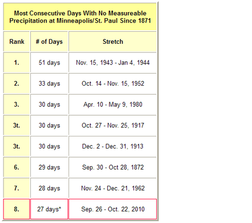
Friday was the 27th consecutive day without measureable rainfall in the Twin Cities. That's the longest dry spell in in the metro 30 years. The longest dry spell in 30 years!
The 27 day drought marks the 8th longest dry stretch on record in the Twin Cities since 1871. The last time we had this many dry days in a row was April & May 1980. The longest dry spell on record was 51 days spanning 1943-44. Here are the details from the Twin Cities NWS.
Create a More Connected Minnesota
MPR News is your trusted resource for the news you need. With your support, MPR News brings accessible, courageous journalism and authentic conversation to everyone - free of paywalls and barriers. Your gift makes a difference.
Warm too:
Not only is October 2010 bone dry, temperatures are running a full 6°F above average as well. Even as the weather turns (significantly) colder next week, we're going to finish the month above average. It's just a question of how far above average. October marks the 7th month of the past 8 going back to March that temperatures have been above average in Minnesota.
The image below shows mean atmospheric thickness patterns at 500mb (18,000 feet) over the northern hemisphere during the past 30 days. Above average thickness (ridging) in the upper atmosphere over Minnesota has lead to our Mediterranean climate over the past month.
Rain on the way:
The timing could be better, but this weekend marks the beginning of a change to a wetter and colder weather pattern for Minnesota. It looks like our dry spell will come to and end Saturday. Low pressure tracking through Iowa will push rain showers north into Minnesota Saturday and Sunday. The first wave could arrive Saturday morning.
I don't think the whole weekend will be a wash out, but expect occasional showers both days. Rainfall amounts look light, with most areas picking up between .25" and .50" this weekend.
Stronger system late Monday?
All signs point to a stronger low pressure storm moving into the Upper Midwest late Monday and Tuesday. This could be our first classic fall storm, with a big rain shield spreading in from west to east later on Monday and lingering through Tuesday. There will be a lot of wind with this one...these big "mid-latitude cyclones" pack a punch if they get wound up. And this one looks like it may do just that.
The latest model runs hint that we may catch a break in the clouds early Monday, and that combines with a stiff southerly wind ahead of the low may boost temps into the 60s to near 70 in parts on Minnesota Monday.
Once the rain arrives, temps will fall into the 50s and 40s. It looks like the next system may be warm enough for all rain.
This system looks to bring a good widespread soaking rain to much of the Upper Midwest. Many locations could see rainfall of 1"+ by Tuesday night.
Season's coldest air next week:
Powerful northwest winds will yank down the season's coldest air mass behind the system on Wednesday. It looks like temperatures may be cold enough for the season's first frost and 32 degree temperature at Twin Cities Airport by Thursday morning. It also looks like moisture may be gone by then...keeping the threat for the season's first snowflakes in the metro at bay.
Decent Halloween?
Early signs point to a decent day for Halloween a week from Sunday. The outlook may change...but my early look says clear to partly cloud skies and temps near 50. Not bad for the last day of October!
Hope you got some yard work done today...enjoy the pitter patter of rain that you haven't heard for a month this weekend.
PH