Major fall storm: Rain, wind, snow, frost
The thud you hear coming from the weather lab today is the sound of the other shoe dropping.
Our blissfully long stretch of mild October weather will come to an abrupt end this week as a major fall storm slams into the Upper Midwest. The storm will bring widespread rain and high winds, and possibly the first snowflakes and frost of the season for many Minnesotans.
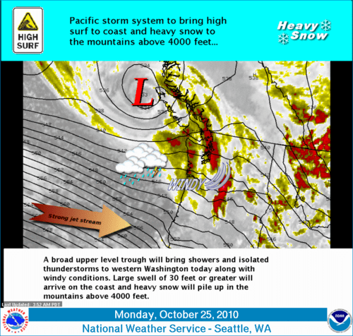
The center of this huge storm is swirling into Vancouver Island in the Pacific Northwest today. This immense and intense weather system covers a lot of real estate, spawning everything from high surf warnings (30'-35' waves!) along the Oregon Coast to thunderstorms and a slight severe weather risk in Madison, Wisconsin later today.
Create a More Connected Minnesota
MPR News is your trusted resource for the news you need. With your support, MPR News brings accessible, courageous journalism and authentic conversation to everyone - free of paywalls and barriers. Your gift makes a difference.
Let's break down the effects for Minnesota.
Rain:
We'll start the week with some fog and misty drizzle today. Rain showers will increase from west to east across Minnesota today and tonight. The heavier, steadier rains will move in tonight into the first half of Tuesday. We may even have a few thunderstorms rumble through overnight into early Tuesday.
Showers will increase today on the milder side of the surface low winding up in the Dakotas.
It looks like a widespread, soaking rain, with many spots in Minnesota picking up 1"+ by the time the rain tapers off from west to east later Tuesday. Drought stricken northeast Minnesota could see the heaviest rain totals.
Wind:
We'll feel breezy southeast to south winds of 10-20 mph on the milder side of the storm today. Winds will diminish some as the center of low pressure slides over Minnesota tonight and early Tuesday. But as the storm wraps up and moves past Minnesota, brutally colder gale force (and tropical storm force) winds will howl in from the west Tuesday through Wednesday.
Sustained winds of 20 to 40 mph will howl late Tuesday through Wednesday, and severe storm level gusts of 50 to 60 mph may rip across the state. What few leaves are left on the trees will be airborne by Tuesday evening.
High wind watches are in effect Tuesday and Wednesday, and will no doubt be upgraded to high winds warnings.
Cold & snow:
The storm will pull down the coldest air so far this fall season by Wednesday.
We'll enjoy one last mild day today with temps in the 60s even with clouds. If we get a few breaks (or even some thinning) in the clouds today temps may briefly jump into the upper 60s.
Temps will plunge from the 50s into the 40s Tuesday on the back side of the storm. By Wednesday 30s will be common, and it looks to be cold enough for (gasp!) snow showers in northern and central Minnesota. The good news is most of the moisture will have pulled east by the time the colder air arrives. There could be some slushy accumulations in the far north, but most of Minnesota will see flakes in the air and not on the (relatively mild) ground.
It is possible that the Twin Cities could see the first snow flakes of the season Wednesday night or early Thursday morning.
Frost:
The system pulls out Thursday leaving cold air in its wake. Look for the season's first frost (including the metro) Thursday and Friday morning. Temperatures could fall into the 28° to 32°F range early Thursday in the south, with lower 20s up north.
Enjoy the mild Monday...and get set for the first taste of real fall (and a wintery preview!) by mid week.
PH