Alberta Clipper On The Way

[image]
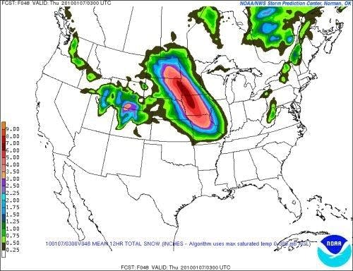
NOAA SPC SREF Model ensemble paints 3" to 6" potential snowfall across southwest Minnesota by Thursday.
Update: The latest model runs seem to hold the trend of 1" to 3" for the metro. We still get two more model runs before the flakes fly Wednesday.
As if you didn't have enough squeaky snow to trudge through.
Create a More Connected Minnesota
MPR News is your trusted resource for the news you need. With your support, MPR News brings accessible, courageous journalism and authentic conversation to everyone - free of paywalls and barriers. Your gift makes a difference.
A classic Alberta Clipper is on track to sail through southwest Minnesota Wednesday. The system looks to bring a shot of dry, powdery snowfall to the eastern Dakotas, southern Minnesota and Iowa as it sails through by Thursday.
Some details:
Track: The upper low will track from Alberta today, into the eastern Dakotas, and into Iowa by Thursday. This track puts the favored area fro the heaviest system snow from the eastern Dakotas into southwest Minnesota and Iowa.
Timing: It appears snow will begin to break out in the Dakotas overnight. Western Minnesota should se snowfall by early morning. Snow should arrive in the Twin Cities by lunchtime Wednesday. Snowfall should end during the day on Thursday from west to east.
Totals: The Clipper appears to have the potential to produce a band of 3" to 5" with some isolated 6" totals in eastern South Dakota, southwest Minnesota, and Iowa. The I-94 corridor, including the Twin Cities appears set for 1" to 3" of snowfall. Any changes in the track could change amounts accordingly.
Wind: There will be strong winds behind the system, especially in southwest and south central Minnesota. Northwest winds of 15 to 25 mph with higher gusts are likely. Blowing and drifting snow and poor visibility will result.
This will be a dry powdery snow. It looks like snow to water ratios could be on the order of 20:1 in the area. This should be a classic Alberta Clipper.
As usual, expect another sub-zero surge of bitter arctic air behind the system Thursday into early Saturday. The cold should ease later Saturday into Sunday and Monday. Highs may reach the mid 20s Sunday, with a shot at 30 Monday. Milder air should bring above average temperaures next week.
[image]
Hang in there!
PH