Boundary Waters blowdown: Storm of the century?

[image]
Track of the July 4th, 1999 Derecheo across northern Minnesota. (Image courtesy Duluth NWS)
Ten years ago this week hurricane force winds devastated parts of the Boundary Waters. Today, that storm lives on as one of the biggest, baddest derecheos ever recorded on the planet. It figures the weather factory in the Upper Midwest would give birth to such a historic storm.
Stephanie Hemphill's piece last week paints a great picture of what things are like in the blowdown areas today near Ely. Meteorologists are still scratching our heads and studying the storm a decade later as well.
Create a More Connected Minnesota
MPR News is your trusted resource for the news you need. With your support, MPR News brings accessible, courageous journalism and authentic conversation to everyone - free of paywalls and barriers. Your gift makes a difference.
It started out as a cluster of thunderstorms near the Black Hills moving northeast. As the storm crossed North Dakota during the overnight hours, it morphed into something much more menacing and dangerous. Around 7 am west of Fargo, it exploded into what we meteorologists call a derecheo.
Derecheos are severe long lived damaging wind storms that can run for hundreds of miles.
Meteorologically speaking, derecheos are defined by three things.
-A path length of at least 250 miles.
-At least 3 reports of hurricane force (74 mph) winds separated by at least 40 miles.
-No more than 3 hours between damaging wind events.
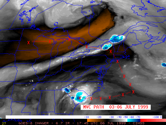
There have been other accounts of so called "trans-continental derecheos" in the past. Some have travelled over 1,000 miles. This one travelled 6,000 miles. That may be the longest recorded path length for a derecheo.
The BWCAW Derecheo may hold another record. It is believed to be the first derecheo ever recorded to have spent over 24 hours over open ocean before returning to land to continue its damaging wind path.
The BWCAW Derecheo's path was amazing. It began in North Dakota then raced through Minnesota at speeds of approaching 100mph near Ely. It tracked into Canada and reentered the U.S., slamming New York and New England. Then it curved southeastward and eventually southwestward in the open Atlantic Ocean around the periphery of a large high pressure system. It re-entered the U.S. in South Carolina causing wind damage there before tracking southwest through the Gulf Coast States into the Gulf of Mexico.
The initial reports from the storm indicated damage in the BWCAW. It took a while to realize how widespread the damage was. It took years to realize how unique and monstrous this storm was on a bigger meteorological scale. We can thank weather satellite and researchers who study storms like this. It is because of them that we have a better understanding of these storms today.
PH