

We have a little more idea what contributed to the tragic crash of an airplane with a Minnesota family aboard last week.
Luke Bucklin and three of his children were killed when their plane slammed into a mountainside in Wyoming. He had taken off in difficult weather, heading for home. His family met with the media today (photo).
Bucklin was an instrument-rated pilot, and had just completed the written portion of the FAA test for a commercial pilot rating. When it came to flying a plane, Bucklin was obviously no slouch.
But a line in the initial National Transportation Safety Board report gives a clue as to why his plane was losing altitude, when it should’ve been climbing to clear the mountain. I’ve put it in bold below:
On October 25, 2010, about 1352 mountain daylight time (MDT), a Mooney M20J, N201HF, collided with mountainous terrain near Lander, Wyoming. The airplane became the subject of a week-long search after it was lost from ground-based radio communications and radar tracking facilities about 45 minutes after it departed from Jackson Hole Airport (JAC), Jackson Hole, Wyoming, on October 25, 2010. On the afternoon of November 1, 2010, the wreckage was located by ground searchers at the 11,100-foot level in the Wind River mountain range, Wyoming. The instrument rated owner/pilot and three passengers were fatally injured and the airplane sustained substantial damage. Instrument meteorological conditions likely existed at the location and time of the accident. The personal flight was operated under the provisions of Title 14 Code of Federal Regulations (CFR) Part 91, on an instrument flight rules (IFR) flight plan and clearance to Pierre, South Dakota.
According to information provided by representatives from Lockheed Martin (LM) and the Federal Aviation Administration (FAA), on the morning of the accident, the pilot obtained his initial telephone weather briefing about 0920 MDT. About 1040, he telephoned again, obtained an abbreviated weather briefing, and filed an IFR flight plan. The flight plan included a planned departure time of 1130, and a destination of Rapid City Regional Airport, (RAP) Rapid City, South Dakota. The filed route of flight was Dunoir (DWN) very high frequency omni-range (VOR) navigation facility, Boysen Reservoir (BOY) VOR, Muddy Mountain (DDY) VOR, and then direct to RAP. About 1237, the pilot used the internet to file another IFR flight plan, which again specified JAC as the origination airport. The filed departure time was 1247, and the filed route was DNW VOR, Riverton (RIW) VOR, DDY VOR, Newcastle (ECS) VOR, Rapid City (RAP) VOR, and Philip (PHP) VOR. The destination was Pierre Regional Airport (PIR), Pierre, South Dakota, and the filed altitude was 9,000 feet. Both weather briefings included AIRMETs (Airmen’s Meteorological Information) for mountain obscuration, turbulence, and icing along the planned flight routes and altitudes.
The airplane departed JAC just after 1300, and was in communication with and tracked by FAA air traffic control (ATC) at Salt Lake City Air Route Traffic Control Center (ARTCC). The first radar target was recorded about 1309, and the airplane was tracked until about 1336, when it was at an altitude of 14,000 feet. About 1341, the pilot filed a pilot report via radio, which stated that he was at 14,000 feet, and was encountering light chop, and a trace of rime icing. The airplane was re-acquired by ground radar about 1346, still at the same altitude. About 1352, the last radar target associated with the airplane was recorded, with an indicated altitude of 13,300 feet. Shortly before that, the pilot radioed to ATC that he was unable to maintain altitude due to mountain wave activity.
According to information provided by the Fremont County Sheriff’s Office, ground searchers located the wreckage at an elevation of 11,100 feet on a scree slope about 6 miles southeast of Gannett Peak. The wreckage exhibited significant crush and impact damage. The right wing was partially fracture-separated from the fuselage, and the propeller blades were fracture-separated from the propeller hub. All components were located within 20 feet of the main wreckage.
The pilot held a private pilot certificate with airplane single land and instrument airplane ratings. The airplane was first registered to him in January 2010. It was manufactured in 1977, and was equipped with a non-turbocharged Lycoming IO-360 series engine.
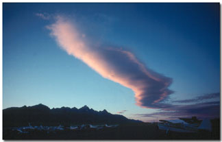 We don’t have, of course, a lot of mountains in the Midwest and it’s a phenomenon that can take a pilot from the flatland by surprise. Pilots are taught to look for an indication of mountain waves by the presence of lenticular clouds, a warning sign to stay away. But in instrument conditions — as in this case — you don’t get the visual warning.
A mountain wave often acts like a “rotor,” the air spins downward, and it tends to follow the terrain on the leeward side of a mountain (click for larger view).
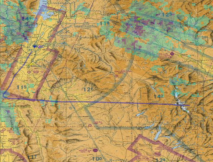
This overlay of Mr. Bucklin’s route on an aviation sectional map lends credence to the theory. He had cleared the peak of the mountain and was on the leeward side.
The United State Airman’s Information Manual carries this warning:
“Your first experience of flying over mountainous terrain, particularly if most of your flight time has been over the flatlands of the Midwest, could be a never-to-be-forgotten nightmare if you are not aware of the potential hazards awaiting … Many pilots go all their lives without understanding what a mountain wave is. Quite a few have lost their lives because of this lack of understanding. One need not be a licensed meteorologist to understand the mountain wave phenomenon.”
The manual advises that pilots should increase their altitude by half the height of the mountain. So, in theory, a safe altitude over Wyoming would’ve been about 21,000 feet. The plane Bucklin was flying does not have the capability to fly at that altitude.
(Photo: At table left to right is Mary Ann Bucklin, Luke’s mom, Ginger Bucklin, wife and Scott Mogen is brother in law of Michelle, mother of boys killed in crash. Others are family members standing behind them. Photo by Tim Nelson)