
(Latest up top)
This is certainly one of the most hyped weather events in the region since last December’s first snowstorm of the year.
2:21 p.m. – The danger has now passed, so this will be the last post in the topic. Here’s the National Weather Service look at the storm. Highest rainfall amount seems to be about 1 1/2″ in St. Cloud.
Most of the damage in the Twin Cities — and there wasn’t much — was from the wind. Panels from the News Cut World Headquarters in St. Paul came loose, prompting the closing of Cedar Street, expertly handled enough police officers to also nab the occasional felon on the run, should one walk by.

12:08 p.m. – Says City-Data.com:
Hubbard County historical area-adjusted tornado activity is significantly below Minnesota state average. It is 15.2 times below overall U.S. average.
12:05 p.m. – Reports of damage from apparent tornado touchdowns are coming in from northwestern Minnesota. The National Storm Prediction Center in Norman, Oklahoma, reports that several houses were destroyed in the unincorporated town of Emmaville in Hubbard County.
Meanwhile, one woman writes to us:
Two of my children are on a 4-H camp outing to Northern Pines Camp near Park Rapids. When I heard reports on MPR of tornado damage near there I called camp out of concern. When I spoke to the 4-H staff person with the kids they were in the storm shelter singing songs and playing games by flashlight as they had no electricity. They were all safe. They were aware of tornado activity both north and south of camp with damage estimated to be about 5 miles from camp. Thank you for alerting me to severe weather in the area where they are camping.
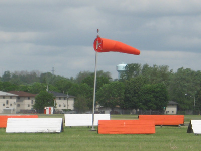
10:38 a.m. – Tornado — or tornadoes — spotted in Hubbard County. MPR’s Tom Robertson is heading there.
7:26 a.m. – High winds knocked down trees in southeast Minnesota, but no significant damage is reported.
11:31 Sump pump? Check. Doors locked? Check. Dog? Check. Check of WCCO’s Good Question in search of possible mention of News Cut? Check. Over and out unless things kick into a higher gear in the early morning.
11:17 p.m. – Watching the big red splotch move up from Iowa, crossing I-35 and heading for SE Minn, and I’m thinking of the people in the Rushford area.
10:38 p.m. – Tornado watch. A whole lot of watchin’ going on this evening. This watch is until 5 a.m. for : Carver Dakota Dodge Fillmore Freeborn GoodhueHennepin Houston Le Sueur McLeod Mower Olmsted Ramsey Rice Scott Sibley Steele Wabasha
Waseca Washington Winona counties.
and in Wisconsin: Buffalo, Chippewa, Clark, Crawford, Dunn, Eau Claire, Grant, Jackson, La Crosse, Monroe, Pepin, Pierce, Richland, St. Croix, Taylor, Trempealeau, and Vernon.
Another big line of storms — after a break — is just hitting I-90, heading north, just to the west of I-35. Should be getting noisy in Austin and Albert Lea soon.
10:25 p.m. – Gate holds and taxi delays at the airport are running 15-29 minutes behind. FAA says the delays are decreasing. I spot checked several flights that were due to arrive during the middle of the evening and they were running about an hour behind schedule.
8:59 p.m. – Dryer sheet/scared dog experiment update. Dog wiped down with Bounce sheet. Dog is the most unnerved in a storm, ever and a thunderstorm just rolled through Woodbury. Mythbuster verdict: Fact! Many thanks to the Current listener who passed along the tip.
8:54 p.m. – St. Cloud Times reporting 3,421 Xcel customers are without power. How are they going to power the sump pumps?
8:50 p.m. – Who among you has a rain gauge? Let’s hear what you’ve got.
8:48 p.m. National Weather Service/Twin Cities storm report shows the path of hail.
8:44 p.m. Paul Douglas’ blog says some 3/4″ hail has been spotted in SW ‘burbs. But no tornado activity. His graphics are positively gobbledygook to me.
8:34 p.m. Most shameful newspaper weather headline of the day comes from the Wichita Eagle. “Last time it looked like this, 22 died.” It’s based on some weather data from 1974.
So far there have been some tornadoes spotted in Kansas but the only incidents reported are that some circus elephants got spooked. So the next time it “looks like this,” does the headline read, “Last time it looked like this some circus elephants got spooked?” The readers are letting the paper have it in the comments section.
5:50 p.m. – Paul Huttner tells Tom Crann a tornado watch is up for tornado alley… the SW Minn/NW Iowa/SE South Dakota region until 1 a.m.
5:46 p.m. – Ready to transfer to News Cut Bunker in Woodbury to monitor the situation. If you listen to the Current, perhaps you know Mary Lucia and I have been considering the assertion that rubbing your dog with dryer sheets will ease his/her anxiety during storms. I’ve been trying it and while the dog is still scared to death, in recent storms he hasn’t been so bad. This animal hospital Web site gives some credence to this. So does this one.
5:39 p.m. – “Not done yet by a long shot,” Paul Huttner says to ATC producer Jeff Jones. He says tornado watch may be posted later for NW Iowa and that system could move into Minn. and the Twin Cities later tonight. Still, some of the natives are getting restless.
5:05 p.m. – A question to ponder while waiting for something to happen… or not: Wisconsin is only 18 miles from downtown St. Paul. So why do we think of a storm as “gone” once it leaves the geographic boundary? Hugo, by contrast, is also 18 miles from downtown St. Paul, yet we don’t consider weather as “gone” when it hits Hugo? Hastings is 20 miles away. That’s still considered “us.” Why isn’t Hudson considered “us”?
5:03 p.m. Quiet. Too quiet. Overblown-media-frenzy quiet.
4:54 p.m. “Get your cars in the garage,” blares the Star Tribune. Hail, you know. I admit to still be impressed by the pictures of damages in the paper Sunday at used car lots and by learning there’s a company that dispatches teams to fix them and it will take months. Browsing the ‘net, we learn that it costs about $1,000 to fix “severe” (61-80 dents) half-dollar-sized hail dents. Interesting pictures from a body shop in Colorado here, although I think the damage caused by a bear attack on that same page is even more interesting.
And how do you know you may have hail damage on your asphalt shingle roof? Check the vents, this document from Canada says. Also features an interesting take on how some of the “stormchaser” companies fake the damage.
4:51 p.m. – The Worthington Daily Globe is live blogging weather there, where there’s flash flood possibilities. So far, the only evidence of pending disaster is the writer has a cold and has run out of Kleenex.
4:49 p.m. – Paul Huttner, MPR meteorologist, says storms will die down in next couple of hours, although central and northern Minnesota may be in for a busy night. Metro area severe thunderstorm warnings have expired.
4:46 p.m. – The first hail picture has arrived:
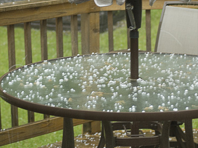
Thanks to Don Householder of Mound, who says he took this picture around 5 p.m. Got a picture or story you want to share? Send it to me.
4:41 p.m. Sirens reportedly went off in Minneapolis. Red Cross posted via Twitter that they were huddled in stairwells. No sirens in St. Paul although one person I’m following just posted, “Who else in St. Paul just saw the sky explode?”