Thursday thunderstorm chances; steamy Friday through Sunday
Twin Cities metro area temperatures reached the mid-80s late Wednesday afternoon, but dew point temperatures were in the comfortable 50s. We have some warmer temps and much stickier dew points in the forecast over the next few days.
Temperature trends
Most of Minnesota plus western Wisconsin will see highs in the 80s Thursday afternoon, with some 70s in parts of northeastern Minnesota. Dew point temperatures in the sticky 60s are expected across roughly the southern two-thirds of Minnesota plus western Wisconsin.
Friday highs will be very warm:
Create a More Connected Minnesota
MPR News is your trusted resource for the news you need. With your support, MPR News brings accessible, courageous journalism and authentic conversation to everyone - free of paywalls and barriers. Your gift makes a difference.

Some spots in the Twin Cities metro area will touch 90 Friday afternoon. Dew point temps in the lower 70s are expected across roughly the southern half of Minnesota plus western Wisconsin Friday afternoon and this weekend.
Saturday highs will reach the 90s in many spots:

Similar highs are expected on Sunday.
Twin Cities metro area highs retreat to the 80s next Monday through Wednesday.
Rain and thunderstorm chances
Showers and thunderstorms are expected to move out of South Dakota late Wednesday evening, then across much of southern and central Minnesota plus western Wisconsin during the overnight hours of Wednesday night and into Thursday morning. A few showers and thunderstorms could redevelop Thursday afternoon and evening.
The National Oceanic and Atmospheric Administration's North American Mesoscale forecast model shows the potential rain pattern Wednesday evening through Thursday evening:

The color chart to the right of the loop refers to the strength of the signal that returns to the radar, not to the amount of rain. It will rain in some areas that look dry in the NAM loop, but the loop shows the general rain pattern within the model.
As always, updated weather information can be heard on the Minnesota Public Radio Network, and you’ll also see updated weather info on the MPR News live weather blog.
You can see the recent local NWS radar loop here. The recent radar loop for southwestern Minnesota can be found here, and the southeastern Minnesota loop here. The northeastern Minnesota radar loop and the northwestern Minnesota radar loop are also available.
Severe weather potential
The Storm Prediction Center of the National Weather Service shows a slight risk of severe weather for much of the southern half of Minnesota through the overnight hours of Wednesday night:

The Wednesday night outlook runs through 7 a.m. Thursday.
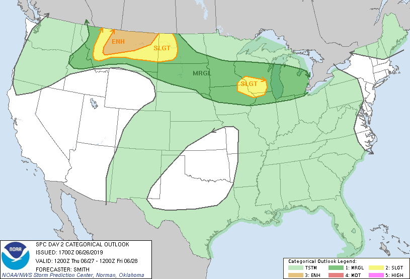
The slight risk area shifts to southeastern Minnesota and southern Wisconsin after 7 a.m. Thursday morning through Thursday night, with the Twin Cities in a marginal risk for severe weather:
Slight risk means that scattered severe thunderstorms are possible:
The NWS Storm Prediction Center will update their severe weather outlooks several times over the next 24 hours.
Lightning safety
This is lightning safety awareness week. According to NOAA, male lightning victims outnumber female lightning victims in the U.S.:
About 25 million cloud-to-ground lightning strikes occur in the United States each year.
Over the last 30 years, the U.S. has averaged 51 lightning fatalities per year
Only about 10% of people struck by lightning are actually killed. The other 90% must cope with varying degrees of discomfort and disability, sometimes for the rest of their lives.
Typically, the vast majority of lightning victims each year are male (in 261 instances from 2006-2013, 81% of lightning fatalities were male and 19% were female).
We can debate the reasons for that male/female difference in lightning victims.