Severe thunderstorm watch until 1 p.m., includes Twin Cities metro
Strong to severe thunderstorms will spread across much of Minnesota and western Wisconsin Thursday morning and into the afternoon.
Severe weather is possible, so make sure that you are sky-aware and that you have a way to receive warnings.
A severe thunderstorm watch continues until 1 p.m. for much of Minnesota and parts of western Wisconsin:
Create a More Connected Minnesota
MPR News is your trusted resource for the news you need. With your support, MPR News brings accessible, courageous journalism and authentic conversation to everyone - free of paywalls and barriers. Your gift makes a difference.

______________________________________________________________________
11 a.m. update
The National Weather Service has removed the 7-county Twin Cities metro area from the severe thunderstorm watch. It remains in effect until 1 p.m. for portions of central and southern Minnesota and western Wisconsin:

Areas color-coded as severe thunderstorm watch and special weather statement remain in the watch.
_________________________________________________________________________
The National Oceanic and Atmospheric Administration’s High-Resolution Rapid Refresh (HRRR) model shows the potential rain pattern Thursday and Thursday evening:
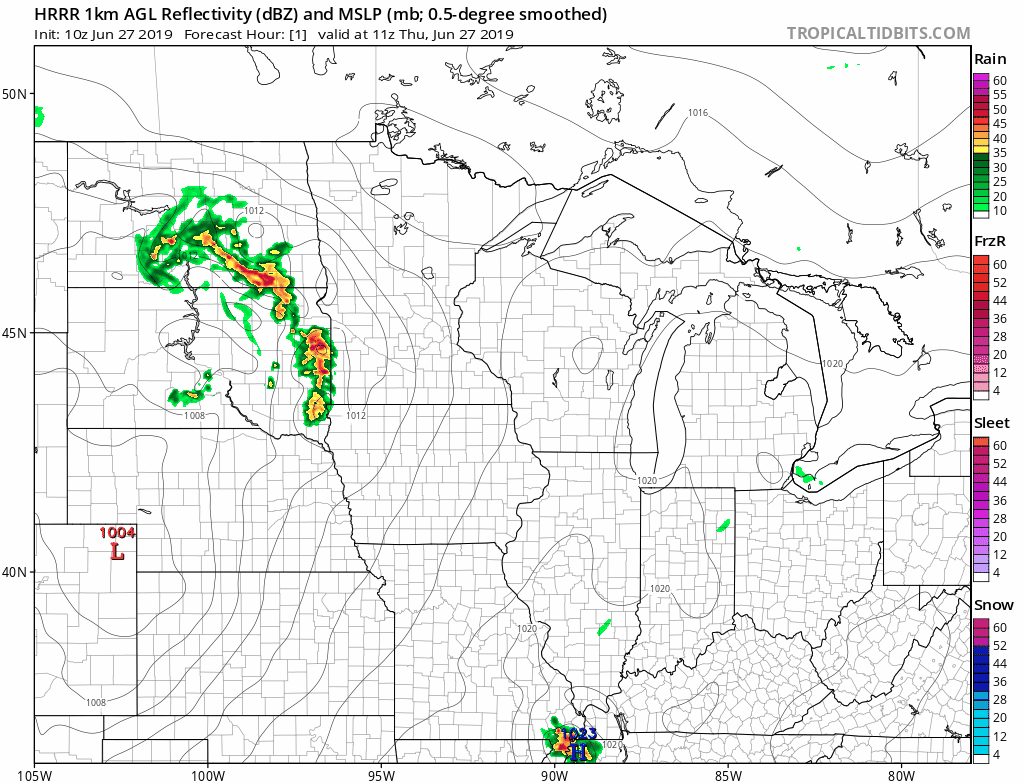
The color chart to the right of the loop refers to the strength of the signal that returns to the radar, not to the amount of rain. It will rain in some areas that look dry in the HRRR loop, but the loop shows the general rain pattern within the model.
As always, updated weather information can be heard on the Minnesota Public Radio Network, and you’ll also see updated weather info on the MPR News live weather blog.
You can see the recent local National Weather Service radar loop here. The recent radar loop for southwestern Minnesota can be found here, and the southeastern Minnesota loop here. The northeastern Minnesota radar loop and the northwestern Minnesota radar loop are also available.
Heat and humidity
Temperatures will drop as the thunderstorms move through today, but they should bounce back later this afternoon.
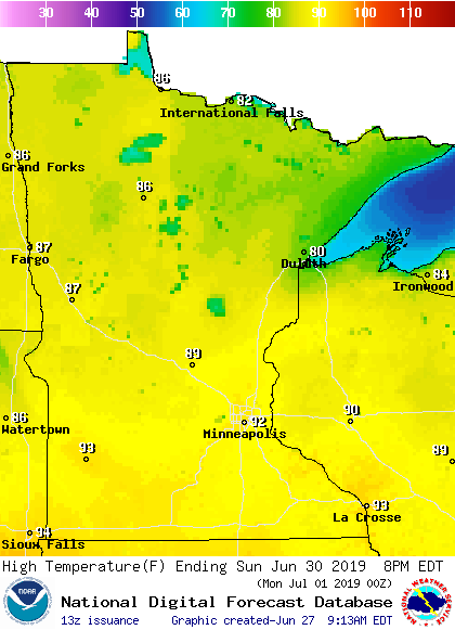
Most of Minnesota will see Thursday afternoon highs in the 80s, with some 70s in parts of the northeast.
Friday highs will be mainly in the 80s, but a few spots in the metro area and southern Minnesota could touch 90:

Dew points in the lower 70s are expected across about the southern half of Minnesota, plus western Wisconsin Friday afternoon through Sunday.
Saturday highs will be in the 90s in many areas:

Sunday will also be hot:
Twin Cities metro area highs are projected to be in the mid 80s Monday through Wednesday.