Some Friday showers, but the weekend looks nice; rivers are rising again
After two consecutive bad hair days, you'll be happy to know that the winds will taper off a bit as we go through Thursday afternoon. Our Thursday highs will be cool, but milder temps are on tap for the weekend.
On to the details.
Temperature trends
Our average high temp is 71 degrees this time of year in the Twin Cities metro area. We'll top out in the 60s Thursday afternoon, sharing those 60s with much of Minnesota. Parts of northern Minnesota will top out in the 50s.
Create a More Connected Minnesota
MPR News is your trusted resource for the news you need. With your support, MPR News brings accessible, courageous journalism and authentic conversation to everyone - free of paywalls and barriers. Your gift makes a difference.
Highs in the 70s return to southern Minnesota and the Twin Cities metro area on Friday:

Many areas reach the 70s on Saturday too:

Sunday's highs look pleasant for late May:
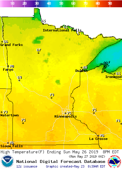
As of now, it looks like most of Minnesota will top out in the 60s on Memorial Day, with a few 50s in northeastern Minnesota.
Rain chances
Scattered showers and a few embedded thunderstorms are expected to spread across Minnesota and western Wisconsin during the overnight hours of Thursday night. Periods of showers/embedded thunderstorms are possible over southern Minnesota Friday morning and early afternoon, but they could linger over northern Minnesota through much of Friday.
The National Oceanic and Atmospheric Administration's North American Mesoscale forecast model shows the potential rain pattern Thursday evening through Friday evening:
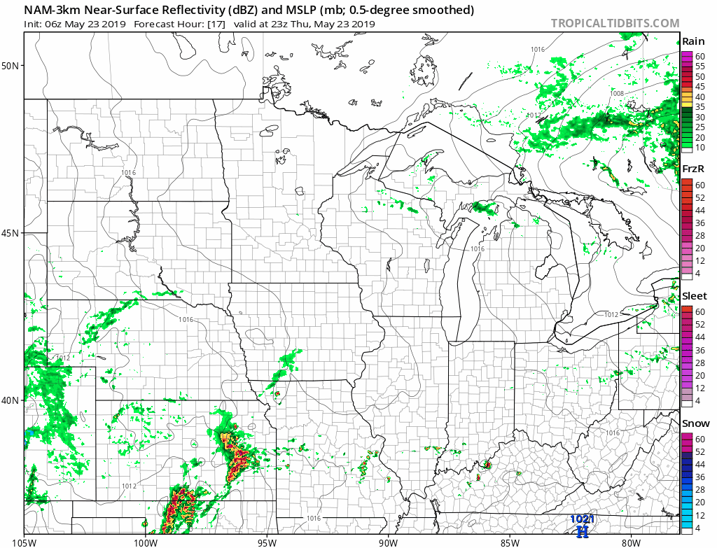
The color chart to the right of the loop refers to the strength of the signal that returns to the radar, not to the amount of rain.
At this point, it looks like most of Minnesota and western Wisconsin will see some periods of rain on Memorial Day. There could also be some scattered thunderstorms. We'll keep you updated.
As always, updated weather information can be heard on the Minnesota Public Radio Network, and you’ll also see updated weather info on the MPR News live weather blog.
River levels
Recent rainy weather has caused river levels to rise again across much of southern Minnesota. Some have reached flood stage or will reach flood stage in the coming days.
You can click on any location on the NWS Advanced Hydrologic Prediction Service (AHPS) site to get hydrographs of recent and forecast river levels. Some locations list levels in feet above sea level, others list levels in feet above a local reference point.
Here’s the Thursday morning hydrograph for the Mississippi River at St. Paul:

You can see that the Mississippi River is expected to touch flood stage at the St. Paul location on Memorial Day.
There are still flood warnings along some rivers in Minnesota. You can get flood warning updates by clicking on any green-shaded location on the National Weather Service Twin Cities website.
Here’s how the NWS map looked this (Thursday) morning:

Projected river levels are updated on a regular basis, so check back to the AHPS site and the National Weather Service point forecasts for the latest info on the rivers near you.
If you’d like to scroll through hydrographs along a certain river in central or southern Minnesota, check here.
Programming note
You can hear my live weather updates on Minnesota Public Radio at 7:49 a.m. Thursdays and Fridays, and at 7:35 a.m., 9:35 a.m. and 4:35 p.m. each Saturday and Sunday.