Snowstorm recap; another big storm this weekend?
Wednesday's snow blitz dropped 8.9 inches of fresh snow at Minneapolis-St. Paul International Airport. Our official Twin Cities February snow total is now at 31.5 inches:

This is now the snowiest February in Twin Cities snowfall records, which date back to 1885!
February 2019 is also the 10th snowiest single month in Twin Cities weather records, and we could move up that list with additional snow this weekend.
Let's rest our shoveling muscles for now.
Create a More Connected Minnesota
MPR News is your trusted resource for the news you need. With your support, MPR News brings accessible, courageous journalism and authentic conversation to everyone - free of paywalls and barriers. Your gift makes a difference.
Wednesday snow totals
Snow totals in the 8- to 10-inch range were common across the Twin Cities metro area on Wednesday. Belle Plaine, in Scott County, came in with 12.8 inches of snow.
A swath of 8 inches or more was indicated from southwestern Minnesota through the metro area:

You can check snow accumulations as they are posted by the National Weather Service. Hover over a location on the National Weather Service snow map site to see the snow total and the time of observation.
If you're looking at the snow map after about noon Thursday, move the slider under the time range in the upper left corner to go back 36 hours and capture Wednesday morning totals in southwestern Minnesota.
There is also a county by county list of snow totals.
The next snowmaker
Northern Minnesota will see some occasional snow showers this Thursday.
The northwestern half of Minnesota has the potential for 2 to 4 inches of snow this Thursday night into Friday:
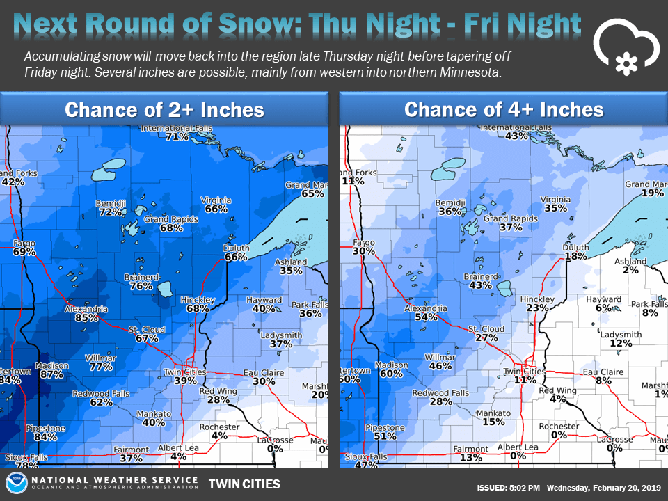
The Twin Cities metro area could see a few flurries Friday morning into Friday afternoon, then one to two inches of snow late Friday afternoon into Friday night.
Weekend storm
Computer models don't agree on the track of the winter storm Saturday afternoon into Sunday.
The National Oceanic and Atmospheric Administration’s Global Forecast System model shows the potential precipitation pattern Saturday afternoon through Sunday afternoon:

The color chart to the right of the loop refers to the precipitation rate (mm per hour), not to the total amount of rain or snow.
The heaviest snow Saturday evening through Sunday is most likely from northeastern Iowa through southeastern Minnesota and portions of Wisconsin:

The Twin Cities metro area might escape with just a few inches of snow Saturday night into Sunday morning, but check forecast updates as the storm track could change.
As always, updated weather information can be heard on the Minnesota Public Radio Network, and you’ll also see updated weather info on the MPR News live weather blog.
You can check the latest forecasts and advisories from the NWS offices in the Twin Cities, Sioux Falls, S.D. and La Crosse, Wis.
Temperature trends
Thursday afternoon highs will be in the 20s across most of Minnesota, with some teens in northwestern and west-central Minnesota.
Friday's highs range from upper teens northwest to lower 30s southeast:

Saturday highs reach the 30s in the east, with 20s west:

Highs dip a bit on Sunday:

We'll have very cold temps as we start the coming week. Twin Cities metro highs only hit about 11 degrees on Monday, followed by 18 on Tuesday and 12 degrees on Wednesday.
Programming note
You can hear my live weather updates on Minnesota Public Radio at 7:49 a.m. Thursdays and Fridays, and at 7:35 a.m., 9:35 a.m. and 4:35 p.m. each Saturday and Sunday.