February snowfall record? Snow again Wednesday, heavier weekend snow?
This February is the wintry gift that keeps on giving.
The jet stream pattern over North America continues to spin low-pressure systems into the Upper Midwest every 3 to 4 days. Commuters can be grateful for dry commutes today and Tuesday. Snow lovers will appreciate Wednesday. And a few models hint at a potentially bigger snowfall event next weekend.
There's a little something for everyone in the forecast this week.
Record February snowfall
Create a More Connected Minnesota
MPR News is your trusted resource for the news you need. With your support, MPR News brings accessible, courageous journalism and authentic conversation to everyone - free of paywalls and barriers. Your gift makes a difference.
We've already recorded the 4th snowiest February on record in the Twin Cities with 22.6-inches so far this month. Another 4-inches will set a new record for the snowiest February on record.
Will we get there this week? As the Magic 8-Ball would say; "signs point to yes."

Dry commutes through Tuesday
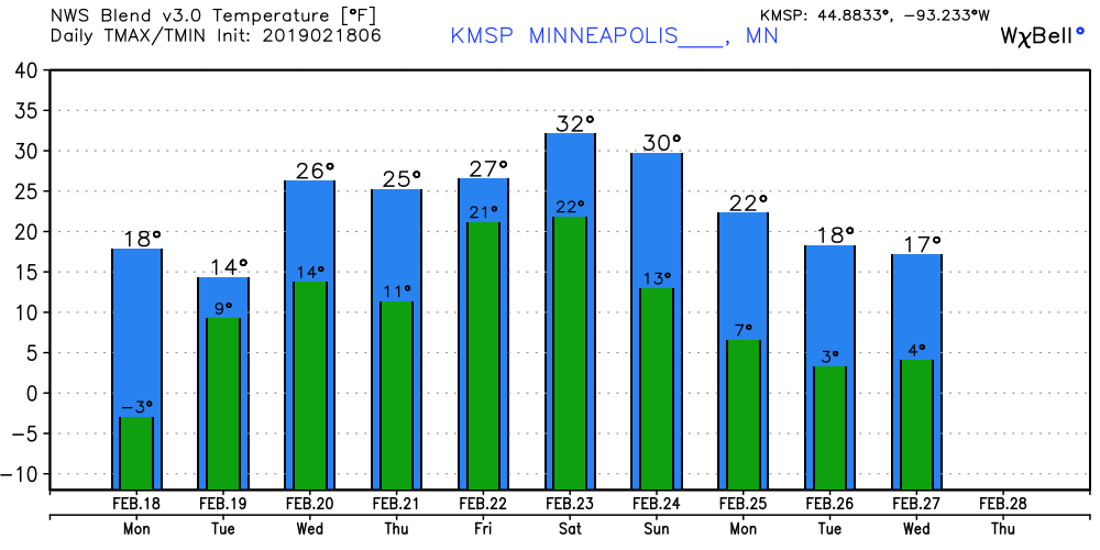
We string together 2 days of dry commutes across Minnesota to open the week. Arctic air rules through Tuesday. Temperatures moderate as the week unfolds. But the milder air comes with a price tag. 30s (above zero) by the weekend will feel remarkably mild.
Wednesday snow
Our next snowmaker arrives in the wee small hours Wednesday. Snow spreads across the region Wednesday morning. It appears both rush hours will be impacted by snow Wednesday.
Here's NOAA's GFS model.

The still early model snowfall totals range between 2 and 6 inches for the Twin Cities Wednesday. The odds of at least 4-inches look high at this point. The heaviest snow may lay out across southeast Minnesota into Wisconsin once again.

Weekend snow blitz?
I'm pretty confident in plowable snow Wednesday. I'm less confident about the track and magnitude of a possible weekend snow event. Several models advertise a potentially bigger snow system in the Friday through Sunday time frame. There are differences in timing and track. A few models keep the heaviest snow south of the Twin Cities. Some blast the metro with the potential for double-digit snowfall.
Keep in mind that the map below will probably change significantly in the next 72 hours. That said, here's NOAA's GFS model from the overnight (06Z) run. I don't like systems that come in two pieces (Friday and Saturday-Sunday) like this suggests. This model path suggests the heaviest snow would be across southeast Minnesota.

It will be interesting to watch the models unfold on the potential for heavy weekend snow as the week progresses.
Stay tuned.