Snow returns Sunday; we could see a lot of snow on Tuesday
Temperatures will be cold today, but winds will be reasonable.
There's plenty of snow cover all across Minnesota right now, which is great for cross-country skiers, snowmobilers and kids with sleds.
Temperature trends
Saturday afternoon highs should reach the single-digits above zero in most of northern and central Minnesota, with some lower teens in the south.
Create a More Connected Minnesota
MPR News is your trusted resource for the news you need. With your support, MPR News brings accessible, courageous journalism and authentic conversation to everyone - free of paywalls and barriers. Your gift makes a difference.
We'll be a few degrees warmer on Sunday, with highs in the teens in many areas and some lower 20s in the southeast:

Most of Minnesota will see highs in the 20s on Monday:

The Twin Cities metro area will peak in the mid to upper 20s on Tuesday, then our Wednesday high will be around 20. We'll probably reach the mid 20s Thursday, then retreat to the lower 20s on Friday.
Sunday snow
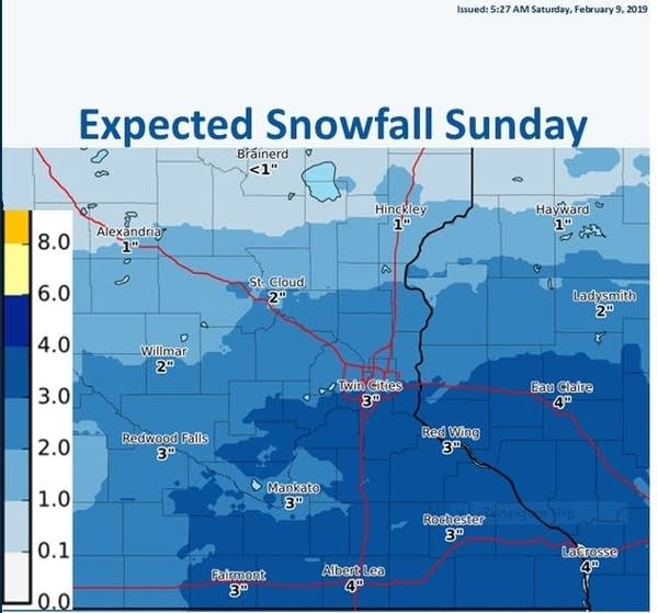
Most of Minnesota will see some snow on Sunday.
The National Oceanic and Atmospheric Administration’s North American Mesoscale forecast model shows the potential snow pattern Sunday and Sunday night:

It'll be enough to shovel:

As always, updated weather information can be heard on the Minnesota Public Radio Network, and you’ll also see updated weather info on the MPR News live weather blog.
_________________________________________________________________________
3 P.M. update
The NWS has issued a winter weather advisory that runs from 6 a.m. Sunday to 6 p.m. Sunday for the southeast part of the Twin Cities metro area, plus south-central and southeastern Minnesota and west-central and southwestern Wisconsin:

The winter weather advisory in Cottonwood and Jackson counties of southwestern Minnesota runs from 4 a.m. Sunday to 3 p.m. Sunday.
Here are details of the advisory that includes the southeastern part of the metro area on Sunday:
URGENT - WINTER WEATHER MESSAGE
National Weather Service Twin Cities/Chanhassen MN
254 PM CST Sat Feb 9 2019
...ANOTHER ROUND OF SNOW DEVELOPING...
.A Winter Weather Advisory has been issued for portions of
southern Minnesota, and west central Wisconsin from 6 AM Sunday
morning, to 6 PM Sunday evening. The advisory is mainly south of
a line from New Ulm, to Prior Lake, and Cottage Grove in
Minnesota, and from River Falls to Bloomer, and southward in
Wisconsin.
Snow is expected to develop along the Iowa border toward sunrise
Sunday, and spread rapidly northeast across far southern Minnesota
by noon. It will also spread into west central Wisconsin by the
early afternoon. Although the snow is not expected to be heavy,
the best time for accumulating snowfall will occur between the
late morning, through the mid afternoon hours. As the snow ends by
Sunday evening, areas in the advisory will receive 3 to 4 inches
of snow, with locally higher amounts possible. Not much wind will
accompany this storm, but some drifting is likely in open country.
The main hazard will be snow covered roads with slippery
conditions developing.
MNZ063-069-070-074>078-082>085-091>093-WIZ023>028-100500-
/O.NEW.KMPX.WW.Y.0012.190210T1200Z-190211T0000Z/
Washington-Scott-Dakota-Brown-Nicollet-Le Sueur-Rice-Goodhue-
Watonwan-Blue Earth-Waseca-Steele-Martin-Faribault-Freeborn-
St. Croix-Pierce-Dunn-Pepin-Chippewa-Eau Claire-
Including the cities of Stillwater, Shakopee, Hastings, New Ulm,
St Peter, Le Sueur, Faribault, Red Wing, St James, Mankato,
Waseca, Owatonna, Fairmont, Blue Earth, Albert Lea, Hudson,
River Falls, Prescott, Menomonie, Durand, Chippewa Falls,
and Eau Claire
254 PM CST Sat Feb 9 2019
...WINTER WEATHER ADVISORY IN EFFECT FROM 6 AM TO 6 PM CST
SUNDAY...
* WHAT...Snow expected. Total snow accumulations of 3 to 4
inches, with locally higher amounts possible.
* WHERE...Portions of west central Wisconsin and east central,
south central and southeast Minnesota.
* WHEN...From 6 AM to 6 PM CST Sunday.
* ADDITIONAL DETAILS...Plan on slippery road conditions.
PRECAUTIONARY/PREPAREDNESS ACTIONS...
A Winter Weather Advisory means that periods of snow, sleet or
freezing rain will cause travel difficulties. Expect slippery
roads and limited visibilities, and use caution while driving.
The latest road conditions for Minnesota can be found at
511mn.org and for Wisconsin at 511wi.gov, or by calling 5 1 1 in
either state.
_________________________________________________________________________
Tuesday snowstorm potential
Computer models continue to show a strong low pressure system tracking to our southeast on Monday night and Tuesday, spinning plenty of moisture over Minnesota and Wisconsin.
NOAA’s Global Forecast System model shows the potential precipitation pattern from late Monday through Tuesday:

The color chart to the right of the loop refers to the precipitation rate (mm per hour), not to the total amount of snow or rain.
The Twin Cities metro area and points to the south and east could see the heaviest snow:

Tuesday morning and evening commutes could be very slow. Check forecast updates as we get closer to Tuesday,
Snowiest February?
We've seen plenty of snow this month. The February snowfall total at Minneapolis-St. Paul International Airport is already at 10.4 inches. We only need 5.8 inches of snow to put this into our top 10 snowiest Februarys in the Twin Cities:

Our 30-year average (1981-2010) for February snowfall is 7.8 inches in the Twin Cities.
Programming note
You can hear my live weather updates on Minnesota Public Radio at 7:49 a.m. Thursdays and Fridays, and at 7:35 a.m., 9:35 a.m. and 4:35 p.m. each Saturday and Sunday.