Saturday snow blitz on the way
Here we go again.
Our next snowmaker is on the way for Saturday. This system packs a little more punch than last night's impressive (and beautiful) snowfall.
Winter storm warnings are up for much of Minnesota Saturday.

Here's my latest thinking on our inbound storm.
Create a More Connected Minnesota
MPR News is your trusted resource for the news you need. With your support, MPR News brings accessible, courageous journalism and authentic conversation to everyone - free of paywalls and barriers. Your gift makes a difference.
Winter storm warnings go in effect for the Twin Cities (and much of Minnesota) at 3 pm tomorrow.
Snow moves into the Twin Cities tomorrow afternoon, most likely between 3 p.m. and 6 p.m.
Heaviest snowfall Saturday evening into the overnight hours.
Snowfall rates could reach 1 inch per hour Saturday night.
Thundersnow is possible.
For the Twin Cities, snowfall totals of 4 to 8 inches are likely, with some local 10-inch totals possible.
For Duluth and the North Shore, snowfall totals of 8 to 12 inches are likely with some lake-enhanced totals near the North Shore.
The heaviest snow bands will likely set up from Albert Lea in southern Minnesota, to just east of the Twin Cities through Duluth and the North Shore.
The system
Saturday's inbound storm looks a bit more impressive than the last one. Low-pressure winds up and shoves a solid snow shield into Minnesota Saturday afternoon. I like the way the National Oceanic and Atmospheric Administration's NAM 3-kilometer resolution model paints the snow zone moving in Saturday afternoon.

Most models suggest snow in the Twin Cities between about 3 p.m. and 6 p.m. and 3 a.m Sunday. Snowfall rates could reach 1 inch over hour for a few hours Saturday evening through midnight. Thundersnow is possible.
Heavy snow up north
Winter storm warnings include much of northern Minnesota.

URGENT - WINTER WEATHER MESSAGE
National Weather Service Duluth MN
205 PM CST Fri Feb 23 2018
...ANOTHER WINTER STORM TO BRING ACCUMULATING SNOW TO THE
NORTHLAND SATURDAY EVENING AND SUNDAY MORNING...
.Another winter storm will move northward through the western
Great Lakes region Saturday evening and Sunday morning, bringing
more accumulating snow, particularly to northwest Wisconsin, the
Twin Ports, and the Minnesota Arrowhead. This system will bring
6 to 10 inches of snow to much of the Northland, with possibly up
to 12 inches along the North Shore. Some lake enhancement is
anticipated due to on-shore flow over Lake Superior, leading to
the higher amounts. Travel impacts are expected, including
hazardous road conditions and reduced visibilities. Sunday morning
travel could be particularly hazardous.
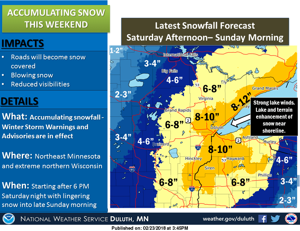
Bottom Line: Prepare for another shot of heavy snow from late Saturday afternoon through Saturday night. This system will have more winds (gusts to 30 mph) so blowing and drifting snow will be an issue. Road conditions will deteriorate rapidly Saturday evening.
Last night's snowfall
Overnight snowfall totals ran between 3 and 5+ inches in of most of the Twin Cities.

Here's the wider map and links to snowfall totals by county from the Twin Cities National Weather Service office.
Enjoy the snow and be safe out there.