More snowstorm numbers; a breezy but beautiful Sunday
Our fresh snow cover is beautiful to look at, but some of us still have to finish our shoveling and plowing.
It's nice that we have plenty of snow for cross-country skiing, sledding and snowboarding:

By late Sunday morning, there were already a lot of people sliding down the hill (below the water tower) at Highland National Golf Course in St. Paul.
Some numbers
Create a More Connected Minnesota
MPR News is your trusted resource for the news you need. With your support, MPR News brings accessible, courageous journalism and authentic conversation to everyone - free of paywalls and barriers. Your gift makes a difference.
The official snow total at Minneapolis-St. Paul International Airport airport was 6 inches, which is a new snowfall record for February 24. The storm dropped around 6 inches of snow across much of the Twin Cities metro area, but I saw 7 inches listed for Maple Plain and Excelsior in western Hennepin county, 8 inches in Oak Grove (northern Anoka county), and 7 inches in Forest Lake (northern Washington county). Parts of the far south metro were closer to 5 inches.
Elsewhere in Minnesota, Little Falls received 7 inches and St. Cloud reported 6 inches from our weekend storm. Duluth’s total was 7.2 inches. I saw reports of 8.5 inches at Two Harbors and 8 inches in Isanti. As expected, snow totals were much lower in southeastern Minnesota, with only about 2 to 3 inches in the Rochester area.
The National Weather Service will update its snowfall map as new snowfall reports arrive. It’s a zoomable map, and you can hover over a point to get details about the location and the time of the snow measurement.
You can also view snowfall reports and summaries as they are posted by the NWS.
Updates
As we clean up from the storm today, updated weather information can be heard on the Minnesota Public Radio Network, and you can read about weather updates on the MPR News live weather blog.
The Minnesota Department of Transportation and the Wisconsin Department of Transportation will post road condition updates.
A nice Sunday, a bit warmer on Monday
Far northern Minnesota could see a few scattered light snow showers this Sunday, but most of us will just have a breezy day and a cloud/sun mix.
Highs Sunday afternoon are expected to reach the lower 30s in much of southern Minnesota, with mostly 20s in the north.
Most of Minnesota will see highs in the 30s on Monday:
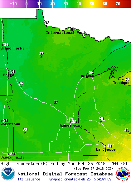
Many spots in central and southern Minnesota will climb into the upper 30s Monday afternoon.
Twin Cities metro area highs are expected to be in the upper 30s throughout this coming week.
An eye on Wednesday night
A storm system might clip southeastern Minnesota with some snow Wednesday night into early Thursday.
We'll be watching the computer models over the next few days to see if the system will veer closer to Minnesota or track to the right a bit.
The National Oceanic and Atmospheric Administration’s Global Forecast System model shows the potential precipitation pattern Wednesday evening though Thursday:

The color chart to the right of the loop refers to the precipitation rate (mm per hour), not to the total amount of snow.
Programming note
You can hear my live weather updates on Minnesota Public Radio at 7:49 a.m. Thursdays and Fridays, and at 7:35 a.m., 9:35 a.m. and 4:35 p.m. each Saturday and Sunday.