A warm Friday; steamy Saturday
It'll feel like July this Friday across most of Minnesota.
Highs in the 80s are expected over much of Minnesota, and some spots in the southwest could poke into the 90s.
Northeastern Minnesota will be in the 70s, and some spots along the north shore could stay in the 60s.
Friday rain chances
Create a More Connected Minnesota
MPR News is your trusted resource for the news you need. With your support, MPR News brings accessible, courageous journalism and authentic conversation to everyone - free of paywalls and barriers. Your gift makes a difference.
Scattered showers and thunderstorms are possible over northwestern Minnesota late Friday, and they could spread eastward Friday night.
The Storm Prediction Center of the National Weather Service shows a slight risk of severe thunderstorms in the northwest Friday and Friday night:

Steamy Saturday
I hope that your air-conditioning is working this weekend.
Computer models still show hot and humid weather for most of Minnesota on Saturday.
Highs will be in the 90s in central and southern Minnesota, with mostly 80s in the north:

Dew points will be in the sticky 60s:

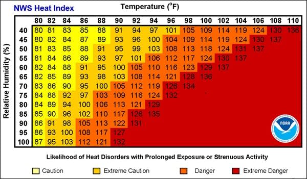
The heat index, which combines the effect of hot temps with humidity, will be near 100 in many spots on Saturday.
It won't be a good day for strenuous outdoor activities.
Sunday's highs will be a bit cooler, but still well above normal in central and southern Minnesota:

Heat safety
The National Weather Service has some good information on how to cope with steamy weather:

This chart gives you an idea on how heat index values rise as the temperature and the relative humidity go up.

NWS
Since it is only early June, we haven't had much time to acclimate to warm and humid conditions this year.
Saturday's steamy weather might stress us more than it would in late July.
Weekend thunderstorm chances
Scattered thunderstorms are possible over far northern Minnesota Saturday morning, and over eastern Minnesota Saturday afternoon and evening.
Periods of showers and thunderstorms are expected in parts of central and southern Minnesota on Sunday.
The National Oceanic and Atmospheric Administration's Global Forecast System model shows the potential rain pattern on Sunday:

The color chart to the right of the loop refers to the precipitation rate (mm/hour), not to the total amount of rainfall.
Check later forecasts, because the rain pattern on Sunday would shift if the front shifts to the north or south.
Programming note
You can hear my live weather updates on Minnesota Public radio at 7:49 a.m. Thursdays and Fridays, and at 7:35 a.m. and 9:35 a.m. each Saturday and Sunday.