Messy Monday; sunshine and 60s return this week
If this is May, give me back February?
A messy and wintry storm system swirls across Minnesota today. The meteorologically impressive system swirls northeast from Oklahoma toward the Upper Midwest.
The sloppy rain and snow system lingers today. It's mostly rain for the Twin Cities. A sloppy slush layer continues from southwestern Minnesota communities through Brainerd to the Iron Range.
The good weather news this first week of May? A classic spring weather pattern evolves starting Thursday. Sunshine returns and temperatures will be 30 degrees warmer as we enjoy highs in the 60s by Thursday and Friday.
Create a More Connected Minnesota
MPR News is your trusted resource for the news you need. With your support, MPR News brings accessible, courageous journalism and authentic conversation to everyone - free of paywalls and barriers. Your gift makes a difference.
This too shall pass. Hang in there Minnesota.
Sloppy, slushy scenes
My friend Matt Brickman over at WCCO-TV tweets the essence of the slop storm in progress today in much of southwestern, central and northeastern Minnesota. How exactly did we survive before Twitter anyway?
Sioux Falls, S.D., looks more like late March than the first of May.
The snowy coating in Minnesota runs all the way up through Brainerd to the Iron Range.
Winter weather advisories, in May
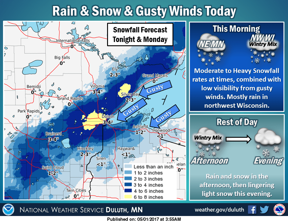
Winter weather advisories and winter storm warnings still fly across Minnesota today. Here's the snowy story from the Duluth National Weather Service office. The snow band is narrow, but significant.
Roads in southwest and central Minnesota are slick.
Twin Cities rain
In the Twin Cities it's just warm enough for mostly rain with a few wet snowflakes mixed in at times. Watch the low-pressure storm swirl as it exits by midnight tonight.

The National Oceanic and Atmospheric Administration's North American Mesoscale Forecast System 3 km resolution model put a finer point on the evolving rain and snow zones today.

Snowfall totals will be slushy, and some melting will occur as the snow falls today.

Deadly southern severe outbreak
We're getting off lucky compared to the southern Plains. I'm not complaining about the cold rain and snow. About two dozen tornado reports are in to NOAA's Storm Prediction Center over the weekend.

Several fatalities from tornadoes and flash floods are reported. Multiple tornadoes tore across eastern Texas.
Damage is extensive.
Warmer days ahead
The sun may peek out tomorrow across Minnesota. We endure one more batch of showers Wednesday. Then a sunnier, drier and warmer weather pattern emerges Thursday through the weekend into early next week.
Temperatures rebound into the springy 60s later this week. Next weekend looks simply gorgeous.
Time to plant those petunias?

The upper air pattern favors warmth into early next week.

Temps may hit 70 degrees in the Twin Cities and much of Minnesota next Monday and Tuesday. It's nice to see red return to the long range temperatures maps.

Hang in there Minnesota!