Weekend split: Spectacular Saturday, Sunday soaker

Just living is not enough... one must have sunshine, freedom, and a little flower. -Hans Christian Andersen
Total sunshine
A remarkably dry spring air mass overhead brings abundant sunshine to Minnesota these days.
Create a More Connected Minnesota
MPR News is your trusted resource for the news you need. With your support, MPR News brings accessible, courageous journalism and authentic conversation to everyone - free of paywalls and barriers. Your gift makes a difference.
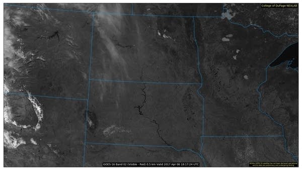
Check out the new and now operational GOES 16 0.5 km visible satellite image. Clear skies dominate the Upper Midwest. Note Minnesota's still frozen bigger lakes Like Mille Lacs, Leech, Red, and Lake of the Woods. The Missouri River is clearly visible. The Black Hills show up as clearly, well, black. To the west, the snow-capped Big Horn Mountains in Wyoming.

Weather perfection
Yes, I editorialize in the above title. My informal 30+ year poll of Minnesotans finds that 93.1 percent consider our weather over the next 48 hours to be among the best we'll see all year.
Saturday will be the fifth of the 47 "Top 10 weather days" we'll see this year. Temps soar into the mid 70s Saturday in the metro. In southwestern Minnesota, bank thermometers will flash 80+ in Redwood Falls. Cooler temps return next week.

Sunday soaker
Chalk up another apparent forecast victory for the European Centre for Medium-Range Weather Forecasts model. The National Oceanic and Atmospheric Administration's Global Forecast System has come in line with the European model's consistent notion of a more southerly storm track Sunday.
A swath of soaking rain now looks likely for most of Minnesota Sunday, including the Twin Cities.

Soaking rainfall of one-half inch to 1 inch-plus looks likely Sunday and Monday for much of Minnesota.

Severe risk Sunday?
Following Saturday's unseasonable summer-like warmth, there is a risk a few storms could reach severe limits Sunday in southern Minnesota.

Top 10 warmest year in Minnesota so far
Persistent warmth continues over most of the U.S. for the first three months of this year. For Minnesota, January through March is among the top 10 warmest on record.
19 in a row
March was the 19th straight warmer than average month in the Twin Cities. That's unprecedented in our modern climate record going back into the late 1800s.
Here's more granular detail on our record setting warm streak from the Minnesota Department of Natural Resources State Climatology Office.
[image]
In the Twin Cities, daily temperatures were above average on 19 of 31 days, and the average monthly temperature has now been above the 1981-2010 normal for 19 months in a row.
The Twin Cities have not recorded average monthly temperatures that were below 1981-2010 normals since August 2015. This is the longest above-average monthly temperature streak of any kind on record in the Twin Cities, though it is worth noting that the "normals" refresh every 10 years, and procedures for calculating them have changed over time. As of this writing, only five months out of the last 34 (back to June 2014) have been below normal in the Twin Cities. The second longest streak on record was 16 months, from June 2011 through September 2012.
This climatological decade (beginning January 2011), over 70% of months have been above the 1981-2010 normals. In the previous climatological decade, 68% of months were above the 1971-2000 normals, and the Twin Cities has not had a string of 10 or more cool months since 1964-65. Indeed, the whole of Minnesota has been warming rapidly since about 1970, making above-normal temperatures more likely than below-normal ones, even as the baseline values are updated to reflect the warmer conditions.

El Nino brewing?
An unusually warm bubble of water has been building off the Peruvian coast. Water temperatures of +3 Celsius are likely the driving force behind recent devastating floods in Peru and Columbia. Usually El Nino events build across the Pacific from west to east. This looks like it could develop into an odd, reverse El Nino. The warm water bubble that developed in the eastern Pacific is now propagating westward.

Climate change working into our DNA?
Scientists are finding that changes in climate are already changing the way many species adapt.
Scientists in the streets
Arctic changes continue
Climate Cast
Join me for MPR's Climate Cast as I explore the week's top climate science stories with University of St. Thomas professor John Abraham at 3:20 p.m. and 6:20 p.m. on MPR News stations.
