Showery Wednesday; severe weather awareness week ahead
It's that time of year again Minnesota. Our annual severe weather awareness week arrives next week in Minnesota. Weather blogs and TV meteorologists will blather about tornadoes and severe storms ad nauseam. The main takeaway for you and your family remains common sense, and having a plan before severe weather strikes.

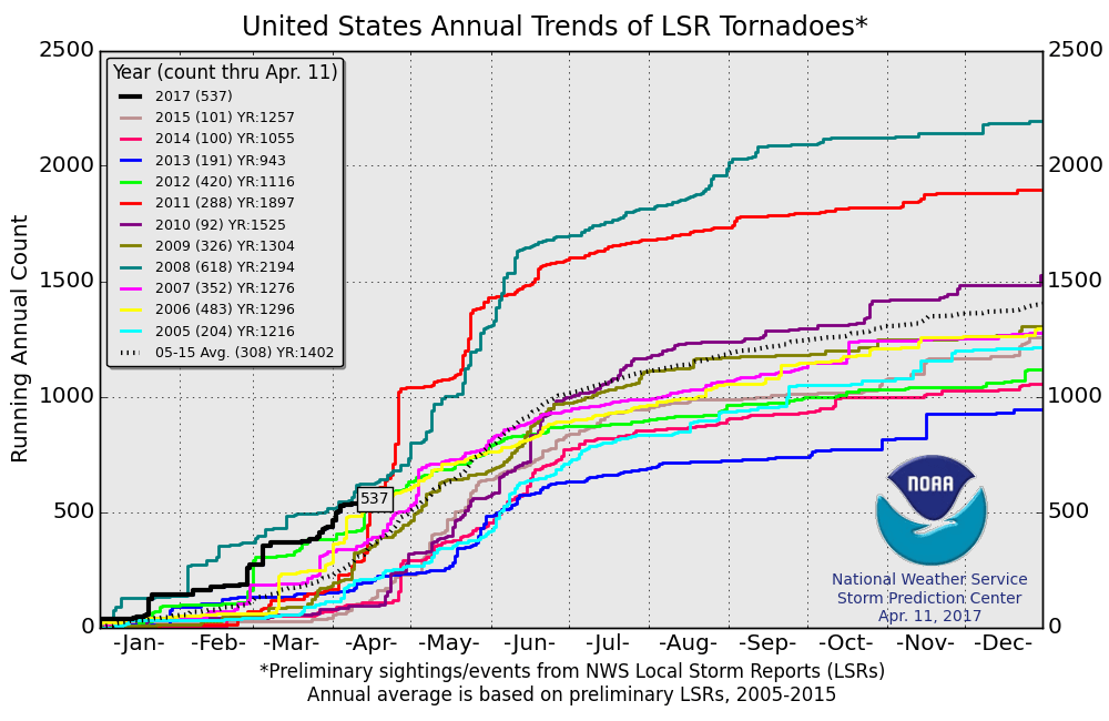
Active tornado season so far
2017 is off to an active start for tornadoes across the U.S.. So far, the National Oceanic and Atmospheric Administration has logged 537 preliminary tornado reports. That's the second most active year since 2005. Only 2008 was more active at this point, with 618 tornadoes at this point in the season.
Showers today
Create a More Connected Minnesota
MPR News is your trusted resource for the news you need. With your support, MPR News brings accessible, courageous journalism and authentic conversation to everyone - free of paywalls and barriers. Your gift makes a difference.
There is no severe threat today, but scattered showers increase in coverage this afternoon. NOAA's high resolution rapid refresh (HRRR) model paints the shower wave across the region into tonight.

Next system Friday
NOAA's North American Mesoscale Forecast System model captures the essence of the two systems on the way this week. Rainfall totals of one-half inch to 1 inch-plus look likely between the two systems by Saturday.

Rain, not snow
At least the precip the next two weeks looks wet and not white. Highs in the 50s and 60s dominate the temperature outlook.

California super bloom amazes
The interesting thing about desert super blooms? It's the rain in fall, and not winter into spring that triggers these amazing displays.
Summery heat arrives early in the northeast
When will Minneapolis-St. Paul see our first 80 degree temp?
Climate satellite data gap ahead?
Millions of years worth of ice cores melt away
This is a paleoclimatologist's worst nightmare. A good reason to have multiple redundant data storage facilities.