“Goldilocks” ice storm up north, 6″metro rain ahead?
It is late April, right?
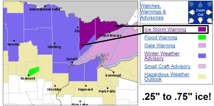
The February that never was, appears determined to show up late to our annual spring party with another wintry onslaught. An ice storm warning is in effect through Wednesday for a big chunk of Minnesota's Arrowhead. residents in the ice storm warning zone should prepare for potential power outages.
Northern Cook/Northern Lake-Southern Cook/North Shore-
Including the cities of Isabella and Grand Marais
243 PM CDT Tue Apr 25 2017
...ICE STORM WARNING REMAINS IN EFFECT FROM 8 PM THIS EVENING TO 10 PM CDT WEDNESDAY...
* LOCATIONS...The eastern half of the Minnesota Arrowhead, including the Grand Portage and Grand Marais areas.
* TIMING...Rain will change to freezing rain this evening, possibly mixing with sleet at times, and continue through at least early Wednesday afternoon. The worst conditions will be late tonight through Wednesday morning.
* ICE ACCUMULATIONS...around one quarter of an inch, and up to three quarters of an inch.
* WINDS...North-northeast 10 to 20 mph with gusts up to 30 mph.
* TEMPERATURES...Beginning in the lower 30s and dropping to the upper 20s overnight. There will be little if any warming during the day Wednesday.
* IMPACTS...Ice covered roadways will become treacherous and impassable. Widespread power outages are likely due to the weight of the ice and snow on tree limbs and power lines. The outages could last for days in some areas.
Create a More Connected Minnesota
MPR News is your trusted resource for the news you need. With your support, MPR News brings accessible, courageous journalism and authentic conversation to everyone - free of paywalls and barriers. Your gift makes a difference.
"Goldilocks" weather event
Ice storms are "Goldilocks" events in weather.
It takes a special set of meteorological conditions to produce ice storms. The thermal profile in the lowest mile of the atmosphere needs to be "just right." Too much warm air and it's all rain. Too much cold air and it's sleet or snow.
Ice storms require a nose of warmer air around 4 to 5 -thousand feet above ground to change precip to rain. Then it takes a shallow layer of freezing air near the ground to freeze rainfall on contact with objects like trees, roads, and power lines.

Here's a good look at the anatomy of wintry precipitation types from NOAA.

Rare late April event
You're not imagining things. Ice storms are rare events. Especially in late April. Average high temperatures in northern Minnesota are now in the 50s. Temps hover just below freezing Wednesday. It's all rain for the metro, but watch as the advancing low pressure system wraps that freezing air into the system's backside and turns wet (green) to snow (blue) and ice (pink).

Snowfall
Deeper into the cold air of north central Minnesota it's mostly snow.
NOAA's GFS has been more consistent than the often irresponsible NAM snowfall totals. This may still be to aggressive, but the notion of several inches of heavy wet snow up north seems perfectly logical by Thursday. Bemidji, Grand Rapids, International Falls, and Ely should look pretty white in the next 48 hours.

Twin Cities: Cold rain
It's a chilly soggy scenario for the Twin Cities and southern Minnesota. It still looks like many of us will pick up .50" to 1" rainfall, with some 1"+ totals.

Wet two weeks
The overall weather pattern still looks exceedingly wet the next two weeks. NOAA's GFS model may, or may not, be overdone. It cranks out 6"+ rainfall totals over a big chunk of southern Minnesota including the Twin Cities over the next 16 days.

The general pattern of wet springs in Minnesota appears to be ready to return this year. If several inches of rainfall comes down over the next two weeks we could be dealing with rivers, lakes, and fields in flood mode as we move into early May.
Stay tuned.