Warmer temps; snow northeastern Minn.
In Lake Wobegon, all the children are above average.
Of course, our temperatures can't always be above average, and we've seen cooler than normal temps in the Twin Cities since March 9.
That's about to change.
Warmer
Create a More Connected Minnesota
MPR News is your trusted resource for the news you need. With your support, MPR News brings accessible, courageous journalism and authentic conversation to everyone - free of paywalls and barriers. Your gift makes a difference.
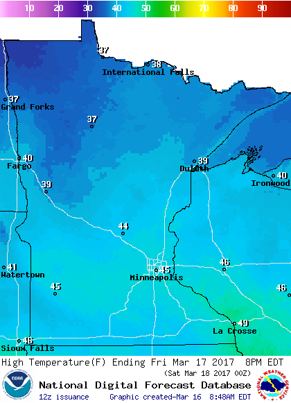
We'll be close to our average high of 41 degrees in the Twin Cities Thursday, and well into the 40s on Friday:
Even northern Minnesota will enjoy a mild St. Patrick's Day, with highs in the upper 30s.
Saturday will be warm for March, with highs in the 40s in central and southern Minnesota, and upper 30s north:

Highs take another jump upward on Sunday, with 50s over much of central and southern Minnesota, and some lower 60s possible to the southwest:

Wintry mix northeast
Some showers could move across parts of Minnesota this Thursday afternoon and evening. In northeastern Minnesota, a mix of rain, snow and freezing drizzle is possible late Thursday and through the overnight hours into early Friday.
The National Oceanic and Atmospheric Administration’s Global Forecast System model shows the possible precipitation pattern:

The color chart to the right of the loop refers to the hourly precipitation rate, not inches of precipitation!
The Duluth office of the National Weather Service has issued a winter weather advisory for much of northeastern Minnesota from this Thursday evening through mid-morning on Friday:

Some details of the advisory:
URGENT - WINTER WEATHER MESSAGE
National Weather Service Duluth MN
417 AM CDT Thu Mar 16 2017
...SNOW FOR THE MINNESOTA ARROWHEAD AND IRON RANGE LATE TODAY AND
TONIGHT...
.A quick burst of snow will impact the Iron Range and Minnesota
Arrowhead late today and tonight. A band of precipitation will
develop across northern Minnesota late this afternoon, mostly rain
at first. Temperatures will drop this evening and bring a quick
transition from rain to snow. The snowfall rates could be intense
at times, reducing visibility to a half mile or less. About 3 to 5
inches of snow are forecast for much of far northeast Minnesota.
Following the snowfall, a period of light freezing rain or
freezing drizzle may produce a glaze of ice.
MNZ011-012-019>021-161930-
/O.NEW.KDLH.WW.Y.0013.170317T0000Z-170317T1400Z/
North St. Louis-Northern Cook/Northern Lake-Central St. Louis-
Southern Lake/North Shore-Southern Cook/North Shore-
Including the cities of Ely, Isabella, Hibbing, Two Harbors,
Silver Bay, and Grand Marais
417 AM CDT Thu Mar 16 2017
...WINTER WEATHER ADVISORY IN EFFECT FROM 7 PM THIS EVENING TO
9 AM CDT FRIDAY...
The National Weather Service in Duluth has issued a Winter
Weather Advisory for Snow and Freezing Drizzle...which is in
effect from 7 PM this evening to 9 AM CDT Friday.
* LOCATIONS...The Iron Range and Minnesota Arrowhead.
* TIMING...Early this evening through the middle of Friday
morning. The snow will fall before dawn Friday.
* SNOW ACCUMULATIONS...3 to 5 inches.
* ICE ACCUMULATIONS...Light, up to a couple hundredths of an inch
of icing.
* VISIBILITIES...Less than a half of a mile at times in the most
intense part of the snow band.
* IMPACTS...Driving conditions will be difficult at times on any
snow covered and icy roads, and in because of the low
visibility in the the most intense part of the snow band.
PRECAUTIONARY/PREPAREDNESS ACTIONS...
A winter weather advisory for snow and freezing drizzle means
that accumulating snow and light icing will cause travel
difficulties. Be prepared for snow covered roads and reduced
visibility...and use caution while driving. Allow extra time to
reach your destination.
Check later forecasts if you plan to be driving in northeastern Minnesota this evening or overnight.
Wall of snow
This dramatic east coast snowstorm video was posted yesterday on YouTube.
According to the caption attached to the video by Nick Colvin:
"Train moving faster than usual plus fresh snow from Stella resulted in a more spectacular arrival than expected."
I hope that the woman with the white hat wasn't injured!
Chris Matyszczyk of cnet sees this as an unwise attempt to capture some great video:
Logic, should you be blessed of any, tells you that when any train comes toward the platform, it might disperse a little snow. Some of it might hit you.
Do you a) stand well away from the tracks? Or b) stay right at the edge of the platform, so that you can take dramatic cellphone footage that will make you the envy of absolutely no one?
Thankfully, most of the people moved away from the tracks as the train approached the station.
Programming note
You can hear my live weather updates on Minnesota Public Radio at 7:49 a.m. Thursdays and Fridays, and at 7:35 a.m. and 4:35 p.m. each Saturday and Sunday.