Slow motion spring; Massive Great Barrier Reef bleaching
Reluctant spring
It's been an unusual winter and early spring season for many Minnesotans. February was the 10th straight warmer than average month for Minnesota, and a record 18th straight warmer than average month for the Twin Cities.
Ironically, chilly Canadian breezes returned in March. Through March 23rd temperatures are running -0.6 degrees vs. average at MSP Airport. But it appears that persistence will win out again this month. Temperatures in the 50s next week are likely next week.
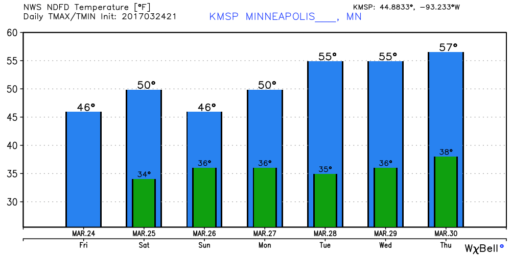
Temperatures are likely to run about 5 degrees warmer than average for the last week of March. That means we'll likely rack up the 19th straight warmer than average month in the Twin Cities
Create a More Connected Minnesota
MPR News is your trusted resource for the news you need. With your support, MPR News brings accessible, courageous journalism and authentic conversation to everyone - free of paywalls and barriers. Your gift makes a difference.
Often in weather, "the trend is your friend."
Southern soaker
Rainfall totals were lighter than expected so far in the Twin Cities. But southern Minnesota got in on a pretty good early spring soaking. Some totals from the La Crosse NWS.
Weekend forecast: Shades of gray
I'm starting to feel like we're living inside a car wash. We could use a little more sun, but we may have to wait until early next week for a fully sunny day. Low pressure slowly spins to the south this weekend. Saturday looks gray but mainly dry. A few spotty showers may swipe us again Sunday.

I was in Chicago for a business meeting Monday. Looks like I picked the wrong day.
Brighter and milder next week
We take another small step forward next week in our slow motion spring. Temps moderate into the 50s. It may actually feel pretty good out there by late next week. Milder hues of yellow pulse northeast by next Thursday and Friday. The latest model trends suggest we may pop into the 60s again across a good chunk of Minnesota by next Friday afternoon.

Warm start to April?
The longer range maps are still hinting at more sustained warmth the first week of April. I expect some of the models will flop around on this, but I think the odds still favor a shot at out first 70- degree temps the first week of April. The jet stream appears ready to shift well north into Canada, blowing much milder air into Minnesota.

NOAA's Climate Prediction Center agrees. Odd favor a warmer than average first week of April for most of the USA including Minnesota.

Windy out there
More than the usual bad hair days lately? It's not your imagination. Winds have been higher than average this month. The monger term trends on winds in Minnesota are hard to quantify, but show some interesting trends. Mark Seeley explains in this week's Weather Talk.
Topic: A few comments about wind
March has been a windy month so far with average daily wind speed over 12 mph, and 9 days with peak wind gust over 30 mph. This continues a trend of windy weather which began the last week of January.
The peak wind gust from MSP airport of 60 mph on the morning of March 8th was just the 5th time in the past 20 years that peak wind gusts in the Twin Cities have hit 60 mph or greater. The other years were 1998 (May), 2007 (Aug), 2008 (June), and 2010 (Oct).
Historical trends in wind speed are difficult to study. There is great geographic disparity across the state. In western Minnesota, as well as the Twin Cities Metro Area wind speeds have been greater than normal more frequently in the months of February, April, and November. over the past two decades. Conversely, over the same time period, wind speeds have generally been less than normal more frequently during the months of May and October.
Great Barrier Reef massive bleaching event continues
Climate scientists are stunned by the shocking massive dead zones on the Great Barrier Reef.
Warm waters are the culprit. Climate Change fingerprints are evident. And it's happening in the absence of an El Nino event this time.
Aerial surveys show massive dead zones in the northern sections.
Ice cover minimums, at both poles.
Climate change concern rising.
War on climate science continues
I'll be sitting in for Kerri Miller with a special 1 hour Climate Cast next Wednesday at 9 am on MPR News stations. I hope you can join us.