Periods of snow into early Wednesday; March outlook
Meteorologists refer to December through February as "meteorological winter", because those are the three coldest months of the year in the northern hemisphere.
The Twin Cities metro area was warmer than normal all three months of this meteorological winter, which ends at midnight Tuesday.
The bitterly cold winter that was forecast by some pundits didn't materialize for Minnesota, but I'm not hearing any complaints!
March outlook
Create a More Connected Minnesota
MPR News is your trusted resource for the news you need. With your support, MPR News brings accessible, courageous journalism and authentic conversation to everyone - free of paywalls and barriers. Your gift makes a difference.
The Climate Prediction Center of the National Oceanic and Atmospheric Administration shows a slight tendency for a warmer than normal March over central and southern Minnesota:

There are likely to be some cool days in March too, but the average temperature for the entire month shows a slight tendency to be warmer than normal in central and southern Minnesota.
Snow for some
A cold front is sagging southward through Minnesota this Tuesday night.
Areas of snow/sleet and rain are along the front this Tuesday evening, and that wintry mix will change to all snow and spread over southern Minnesota overnight, with periods of snow continuing into early Wednesday morning.
NOAA’s North American Mesoscale forecast model shows the precipitation pattern from Tuesday evening through Wednesday:

Another batch of snow moves into western Minnesota Wednesday afternoon.
Snow is depicted by blue areas, rain by green.
The color chart on the lower right of the loop refers to the strength of the radar signal returning to the radar, not inches of snow or rain!
Grassy areas in the Twin Cities could see around one inch of accumulation by Wednesday morning, with two inches possible in the far south metro. Slushy accumulations could cause some slippery spots during the Wednesday morning commute.
Higher snow amounts are possible in southeastern Minnesota and into southern Wisconsin:

Check for forecast updates Wednesday morning.
Cooler temps
Highs Wednesday will be cooler, but close to normal for this time of year. Highs in the 30s are expected over southern and central Minnesota, with 20s to the north:
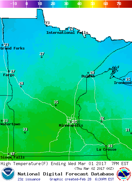
Similar highs are expected on Thursday and Friday.
There is a weekend warmup in the forecast, with the Twin Cities hitting 50 degrees on Saturday and the lower 50s on Sunday.
No sub-zero low temps are expected in the Twin Cities over the next week. The coldest lows on NOAA's Global Forecast System model into the second week of March are in the teens, on March 8, 9 and 10:

We can handle that!