Mild weekend; shower chance late Saturday
This weekend will feel more like March than February.
Saturday afternoon highs will touch 40 in parts of southern Minnesota, with 30s for most of central and northern Minnesota. Far northwestern Minnesota will see upper 20s.
Our Sunday highs will be in the 30s in most areas:
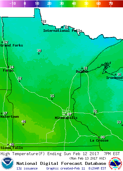
A few spots in southwestern Minnesota could top 40 on Sunday.
Create a More Connected Minnesota
MPR News is your trusted resource for the news you need. With your support, MPR News brings accessible, courageous journalism and authentic conversation to everyone - free of paywalls and barriers. Your gift makes a difference.
Warmth stays with us
Most of next week will be warmer than normal in Minnesota.
The coolest day will probably be Wednesday, with highs in the 20s north and lower 30s south.
The Twin Cities metro area will see highs in the 40s Monday and Friday, with 30s in between.
Our average Twin Cities high temperature rises to 29 degrees by Feb. 14th.
NOAA's Climate Prediction Center shows that above normal temperatures are likely to continue beyond next week:

The temperature outlook covers the period from Feb. 18 through Feb. 24.
NOAA's Global Forecast System model shows highs in the 30s and 40s for the Twin Cities metro area from Feb. 19 through Feb. 25:

Snow is north
The official snow depth measurement at Minneapolis-St. Paul International airport was zero this Saturday morning.
According to the National Weather Service, it is very rare to have no snowcover in the Twin Cities on Feb. 11th:
Of course there is some lingering snowcover on some Twin Cities metro area lawns, especially on areas that don't get much afternoon sunshine.
There is still plenty of snow on the ground in northern Minnesota, especially along and north of a line from around Thief River Falls through Bemidji to Duluth. Duluth had 14 inches of snow on the ground at last report.
Our Thursday snow depth map from the Minnesota State Climatology Office looked like this:

I'm sure that Friday's mild temps melted some of that snow, but the snow depth map illustrates where you have the best chance of finding enough snow for snowmobiling and cross-country skiing this weekend.
Shower chance
Some scattered rain showers could move into southern Minnesota this Saturday afternoon. Southern and central Minnesota will see some showers overnight, the showers could become mixed with snowflakes late Saturday night. There is a good chance of snow showers over northern Minnesota this Saturday evening and Saturday night.
NOAA’s North American Mesoscale forecast model shows the projected precipitation pattern:

Any lingering sprinkles or flakes should move out of eastern Minnesota early Sunday morning.
Programming note
You can hear my live weather updates on Minnesota Public Radio at 7:49 a.m. Fridays, and at 7:35 a.m. and 4:35 p.m. each Saturday and Sunday.