Icy underfoot, afternoon flakes
Do not adjust your computer monitor. That foggy coating you see on the MNDOT traffic cams today is actually a thin icy glaze.
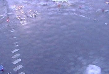
As predicted it's icy underfoot today. Your sidewalk, driveway and parking lots have a thin coating of glaze ice today. In short anything untreated could be slick. The freezing rain advisory has been dropped for the Twin Cities, but today is a perfect study in how just a thin coating of freezing mist can ruin your day.
Be careful out there.
PM snow showers
Create a More Connected Minnesota
MPR News is your trusted resource for the news you need. With your support, MPR News brings accessible, courageous journalism and authentic conversation to everyone - free of paywalls and barriers. Your gift makes a difference.
The low pressure system slides east today. On the backside, a shot of snow showers reaches as far south as the Twin Cities this afternoon. Your lawn could get a thin coating of white today as the wrap-around snow slides in.

48 hours of winter
You'll feel the bracingly cold northwest wind kick in today. The Twin Cities bottoms out in the single digits by morning, with sub-zero temps across a good chunk of northern Minnesota Wednesday and Thursday morning.

Friday rebound
Our attempt at winter this week will be short-lived. A warm front sails north Friday across central Minnesota. To the north of the front, another shot of snow for northern Minnesota. the the south, milder south winds and red dashed lines on the weather map.

Temps Friday surge into the 40s in the Twin Cities, and push 50 degrees in southwest Minnesota.

Roller coaster next two weeks
Looking at the longer range maps, our temperature roller coaster continues the next two weeks. We stay close to 40 this weekend, and into the upper 30s next week. Then a briefly colder shot is followed by another potential thaw the weekend of Feb 18-19.

For a reality check, the average high this week is 27 and the average low is 10.
Early spring in 2017?
February will likely be the 18th straight warmer than average month in the Twin Cities. The early read on March is for persistence. NOAA's Climate Forecast System (CFS2) is cranking out warmer than average temps for March in the Upper Midwest and all of eastern North America.

Winter is fighting to hang on to life. At this rate, it could be an early spring in Minnesota.
Stay tuned.