Blizzard warning southern Minn., advisory southeast metro today
Heavy snow moved through southern Minnesota overnight, and some additional accumulations are expected today.
Strong winds will combine with the snow to cause very low visibilities and difficult travel conditions in southern Minnesota today. A blizzard warning remains in effect for southwestern and south-central Minnesota until midnight, and until 6 a.m. Saturday for southeastern Minnesota:
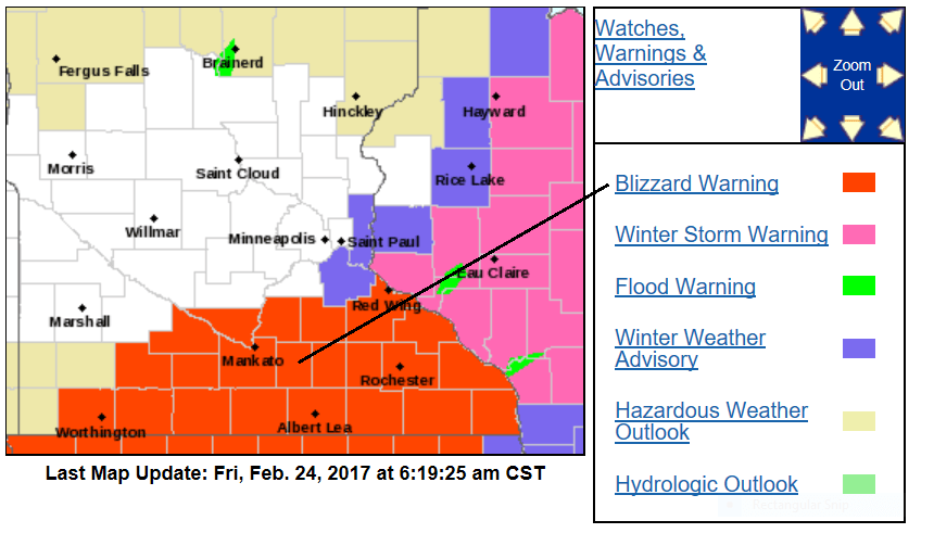
Some details on the blizzard warning:
Create a More Connected Minnesota
MPR News is your trusted resource for the news you need. With your support, MPR News brings accessible, courageous journalism and authentic conversation to everyone - free of paywalls and barriers. Your gift makes a difference.
URGENT - WINTER WEATHER MESSAGE
National Weather Service Twin Cities/Chanhassen MN
407 AM CST Fri Feb 24 2017
...DIFFICULT TRAVEL CONDITIONS OVER SOUTH CENTRAL MINNESOTA AND
INTO PORTIONS OF WEST CENTRAL WISCONSIN...
.A Blizzard Warning is in effect for south central Minnesota,
including the Mankato area, the I-90 corridor, and I-35 corridor
from around Faribault southward. A Winter Storm Warning is in
effect for portions of west central Wisconsin east of a line from
Red Wing to Ladysmith. A Winter Weather Advisory is in effect for
Dakota and Washington county in east central Minnesota and in St
Croix and Barron county in west central Wisconsin.
Snowfall totals between 6 and 12 inches are expected in the
warning areas with up to 6 inches in the advisory area. A few
totals could exceed a foot near the Iowa border.
In addition, wind speeds are expected to increase to 25 and
30 mph, with gusts around 40 mph across south central Minnesota
today. This will lead to significant blowing and drifting snow
and whiteout conditions.
The Friday morning and afternoon commutes are expected to be
significantly impacted. Those traveling south into this band can
expect rapidly deteriorating travel conditions within a very
short distance. Weather conditions will slowly improve into the
evening across the area.
MNZ074>078-082>085-091>093-241815-
/O.EXT.KMPX.BZ.W.0001.000000T0000Z-170225T0600Z/
Brown-Nicollet-Le Sueur-Rice-Goodhue-Watonwan-Blue Earth-Waseca-
Steele-Martin-Faribault-Freeborn-
Including the cities of New Ulm, St Peter, Le Sueur, Faribault,
Red Wing, St James, Mankato, Waseca, Owatonna, Fairmont,
Blue Earth, and Albert Lea
407 AM CST Fri Feb 24 2017
...BLIZZARD WARNING NOW IN EFFECT UNTIL MIDNIGHT CST TONIGHT...
* TIMING...Moderate to heavy snow will continue into at least this
morning...tapering during the afternoon. The heavier
accumulations will occur along the I90 corridor to near Red Wing.
* SNOW ACCUMULATIONS...6 to 12 inches are expected, with the
heaviest totals along the Iowa border.
* WINDS/VISIBILITY...North 25 to 30 mph with gusts to 40 mph
resulting in considerable blowing snow and possible whiteout
conditions.
PRECAUTIONARY/PREPAREDNESS ACTIONS...
A Blizzard Warning means severe winter weather conditions are
expected or occurring. Falling and blowing snow with strong winds
and poor visibilities are likely. This will lead to whiteout
conditions...making travel extremely dangerous. Do not travel. If
you must travel...have a winter survival kit with you. If you get
stranded...stay with your vehicle.
Lighter snow amounts have occurred over the southeast portion of the metro area, and periods of snow are expected today, so a winter weather advisory for snow and blowing snow is in effect until 6 p.m. for Dakota county and Washington county:

Details of the winter weather advisory, from the NWS:
MNZ063-070-241815-
/O.CON.KMPX.WW.Y.0008.000000T0000Z-170225T0000Z/
Washington-Dakota-
Including the cities of Stillwater and Hastings
407 AM CST Fri Feb 24 2017
...WINTER WEATHER ADVISORY REMAINS IN EFFECT UNTIL 6 PM CST THIS
EVENING...
* TIMING...Snow will spread mainly across the southern portions
of the county today.
* SNOW ACCUMULATIONS...2 to 6 inches, with the heaviest amounts
in the southern portions of the county.
* WINDS...North 15 to 25 mph with gusts to 35 mph may result in
areas of blowing and drifting snow.
PRECAUTIONARY/PREPAREDNESS ACTIONS...
A Winter Weather Advisory for snow means that periods of snow
will cause primarily travel difficulties. Be prepared for snow
covered roads and limited visibilities...and use caution while
driving.
The remainder of the metro area has a chance of occasional light snow or flurries today.
A winter storm warning for heavy snow and blowing snow is in effect until 6 a.m. Saturday for parts of west-central and southwestern Wisconsin.
Details of the winter storm warning:
WIZ016-024>028-241815-
/O.CON.KMPX.WS.W.0002.000000T0000Z-170225T1200Z/
Rusk-Pierce-Dunn-Pepin-Chippewa-Eau Claire-
Including the cities of Ladysmith, River Falls, Prescott,
Menomonie, Durand, Chippewa Falls, and Eau Claire
407 AM CST Fri Feb 24 2017
...WINTER STORM WARNING REMAINS IN EFFECT UNTIL 6 AM CST
SATURDAY...
* TIMING...Moderate to heavy snow will continue through the
day...with the heavier accumulation this morning around Eau
Claire.
* SNOW ACCUMULATIONS...6 to 12 inches are expected, with the
highest totals from near Red Wing and Eau Claire.
* WINDS...North 15 to 25 mph with gusts to 35 mph resulting in
areas of blowing and drifting snow.
PRECAUTIONARY/PREPAREDNESS ACTIONS...
A Winter Storm Warning for heavy snow means severe winter weather
conditions are expected or occurring. Significant amounts of snow
are forecast that will make travel dangerous. Only travel in an
emergency. If you must travel...keep an extra flashlight...
food...and water in your vehicle in case of an emergency.
Low moves away
The National Oceanic and Atmospheric Administration’s Global Forecast System model shows that the low pressure system that is causing today's snow and strong winds will move toward Chicago this afternoon:

The snow over southern Minnesota will taper from west to east during the day today, but strong winds will stay with us into tonight.
Updates
Minnesota Public Radio will keep you updated on the winter storm as it continues to develop.
Updated weather information will also be posted on the MPR news live weather blog.
You can also check with the Twin Cities office, La Crosse, WI office and Sioux Falls, SD office of the National Weather Service for weather updates. The NWS sites have clickable maps for the forecast at your specific location.
The Minnesota Department of Transportation will have current road conditions.